Get Data
Summary:
This data set consists of a 1:15 million scale map of forest stand carbon (C) for the land area of Russia (Stone et al. 2000). The objective was to create a first approximation of the forest stand C reserves of Russia. Data include continuous estimates of forest stand C in units of metric tons/ha of C and categorized data depicting ranges of forest stand C. The resulting maps show forest stand C by region in a spatially explicit form. It is the first map of its type for Russia of which we are aware. The mapped C represents 96% of the total of 26.1 Pg forest tree stand C described by Alexeyev and Birdsey (1994) and Alexeyev et al. (1995). Of the remaining 4%, nearly half was due to bushes, which were assumed not to be mapped in the 1973 forest cover map.
The source data for the forest stand C map were acquired by map digitization from the Atlas of Forests for the Soviet Union (State Committee on Forests 1973) and spatial application and arithmetic manipulation of C storage data from Alexeyev and Birdsey (1998).
For related information visit the Woods Hole Research Center (WHRC) web site: http://www.whrc.org/russia/our_work/current_projects/terrestrial_carbon_storage.htm
The data are provided in several formats including binary raster data in Idrisi format, ASCIIGRID raster data in ASCII format (easily imported into ArcInfo), vector data in ArcView shapefile format, and a graphic map in JPEG format (see Figure 1). Please read all documentation before using these files.
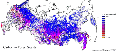
Figure 1. Forest Stand Carbon Map for the Land Area of Russia
Data Citation:
Cite this data set as follows:
Stone, T. A., P. Schlesinger, and V. A. Alexeyev. 2003. RLC Forest Stand Carbon Map of Russia. Data set. Available on-line [http://www.daac.ornl.gov] from Oak Ridge National Laboratory Distributed Active Archive Center, Oak Ridge, Tennessee, U.S.A. doi:10.3334/ORNLDAAC/696.
Table of Contents:
- 1 Data Set Overview
- 2 Data Characteristics
- 3 Applications and Derivation
- 4 Quality Assessment
- 5 Acquisition Materials and Methods
- 6 Data Description and Access
- 7 References
- 8 Glossary and Acronyms
- 9 Document Information
1. Data Set Overview:
Data Set Contents:
A Spatially Explicit Map of Forest Stand Carbon for Russia
Related Data Sets:
See other Russian Land Cover data sets.
Title of Investigation:
Measuring Changes to Russian Forest Over the Last 25 Years
Investigator(s) Name and E-mail:
Name Stone, T. A. tstone@whrc.org Schlesinger, P. pschles@whrc.org Alexeyev, V. A. alexeyev@rcom.mail.ru
Technical Contact(s) Name, Telephone, and E-mail:
Name Phone Schlesinger, P. pschles@whrc.org (508)540-9900
Future Modifications and Plans:
Not available.
2. Data Characteristics:
Study Area:
Spatial Coverage:
Min. X: -4737113
Max. X: 3474887
Min. Y: -1595781
Max. Y: 2952219
In meters from 104.5 degrees E, 56.5 degrees N
Spatial Resolution:
1000 meters (15 kilometers original data)
Projection:
Geographic
Grid Description:
Cols: 8212
Rows: 4548
Resolution: 1000
Temporal Coverage:
Not applicable
Parameter or Variable:
Table for: fcarbon.img
Variable Description Units Instrument Range Forest Stand Carbon Forest stand C for the land area of Russia metric tons/ha Atlas of Forests of the USSR (1973) 0 - 266
Forest Stand Carbon footnote: The source data were acquired by (a) map digitization from the Atlas of Forests for the Soviet Union (State Committee on Forests 1973) and (b) spatial application and arithmetic manipulation of C storage data from Alexeyev and Birdsey (1998).
Table for: fcarbcl.img
Variable Description Units Instrument Range Forest Stand Carbon Forest stand C in 10 metric ton/ha classes for the land area of Russia metric tons/ha Atlas of Forests of the USSR (1973) 11 Categories
Forest Stand Carbon footnote: Forest stand C in 10 metric ton/ha classes.
Category 0 : No Carbon Mapped
Category 1 : 1 - < 10
Category 2 : 10 - < 20
Category 3 : 20 - < 30
Category 4 : 30 - < 40
Category 5 : 40 - < 50
Category 6 : 50 - < 60
Category 7 : 60 - < 70
Category 8 : 70 - < 80
Category 9 : 80 - < 90
Category 10 : 90 - < 100
Category 11 : 100 and > 100
Table for: fcarbon.dat.gz
| Variable | Description | Units | Instrument | Range |
|---|---|---|---|---|
| Forest Stand Carbon | Forest stand C for the land area of Russia | metric tons/ha | Atlas of Forests of the USSR (1973) | 0 - 266 |
Forest Stand Carbon footnote: The source data were acquired by (a) map digitization from the Atlas of Forests for the Soviet Union (State Committee on Forests 1973) and (b) spatial application and arithmetic manipulation of C storage data from Alexeyev and Birdsey (1998).
Table for: fcarbcl.dat.gz
| Variable | Description | Units | Instrument | Range |
|---|---|---|---|---|
| Forest Stand Carbon | Forest stand C in 10 metric ton/ha classes for the land area of Russia | metric tons/ha | Atlas of Forests of the USSR (1973) | 11 Categories |
Forest Stand Carbon footnote: Forest stand C in 10 metric ton/ha classes.
category 0 : No Carbon Mapped
category 1 : 1 - < 10
category 2 : 10 - < 20
category 3 : 20 - < 30
category 4 : 30 - < 40
category 5 : 40 - < 50
category 6 : 50 - < 60
category 7 : 60 - < 70
category 8 : 70 - < 80
category 9 : 80 - < 90
category 10 : 90 - < 100
category 11 : 100 and > 100
Table for: fcarbonv.zip
Contains both continuous and categorized vector map versions of data files.
Data Organization
Please read all documentation before using these files: http://daac.ornl.gov/daacdata/russian_land_cover/forest_carbon/comp/fcarbon_readme.txt and http://daac.ornl.gov/daacdata/russian_land_cover/forest_carbon/comp/fcarbon_projection.txt.
Granule Name or Description:
fcarbon.img
Data Format:
A binary raster image depicting forest stand C in Idrisi format. Note: must be converted to an *rst file when using version 3.2 of Idrisi. Use the Idrisi File Conversion (16/32) utility available in the file pulldown menu to convert to the new format. Also note that the Idrisi v. 2 image documentation file, fcarbon.doc, MUST be present for the binary data to be read by Idrisi.
Sample Data Record:
Not applicable
Granule Name or Description:
fcarbcl.img
Data Format:
A binary raster image depicting ranges of forest stand C in Idrisi format. This map differs from fcarbon* in that the C estimates have been divided into classes based upon value ranges (it is categorical data). Note: must be converted to an *rst file when using version 3.2 of Idrisi. Use the Idrisi File Conversion (16/32) utility available in the file pulldown menu to convert to the new format. Also note that the Idrisi v. 2 image documentation file, fcarbcl.doc, MUST be present for the binary data to be read by Idrisi.
Sample Data Record:
Not applicable
Granule Name or Description:
fcarbon.dat.gz
Data Format:
Compressed ASCIIGRID version of the binary raster data (fcarbon.img). This data file was created by converting the Idrisi binary file (fcarbon.img) using Idrisi export utilities. The ASCII file was compressed using the gzip utility available in UNIX. Note: it was necessary to first convert the *.img file to a *rst file and the *doc file to a *rdc file to match the new file format and naming convention of raster data supported by Idrisi 3.2.
Sample Data Record:
Not applicable
Granule Name or Description:
fcarbcl.dat.gz
Data Format:
Compressed ASCIIGRID version of the binary raster data fcarbcl.img). This data file was created by converting the Idrisi binary file (fcarbcl.img) using Idrisi export utilities. The ASCII file was compressed using the gzip utility available in UNIX. Note: it was necessary to first convert the *.img file to a *rst file and the *doc file to a *rdc file to match the new file format and naming convention of raster data supported by Idrisi 3.2.
Sample Data Record:
Not applicable
Granule Name or Description:
fcarbonv.zip
Data Format:
A vector map versions of data files in ArcView shapefile format (compressed). Zipfile includes fcarbon.shp (and components), fcarbcl.shp (and components), and unmapped.shp (and components).
Sample Data Record:
Not applicable
3. Application and Derivation:
Typical Application of Data:
The data are necessary to understand the spatial distribution of vegetative C for forest management and to help ascertain its role in the global C cycle. If the spatial distribution of C is known, it improves the accuracy of measuring C flux from land use change and help in determining the emissions of gases and particulates from biomass burning. Also, knowing the distribution of C aids in defining respiration values for ecosystem models, provides a baseline for changes in C stocks, and allows for validation for ecological process models and dynamic global vegetation models.
Theory of Measurements:
Not available
Derivation Techniques and Algorithms
Formulae:
Not available
Processing Steps:
We constructed an area-weighted map of forest stand C using data from Alexeyev and Birdsey (1998) and a forest cover map of the Soviet Union digitized from the 1973 Forest Atlas of the USSR (State Committee on Forests 1973). The 1973 map (published at 1:15,000,000 scale) comprises twenty-two different cover types: Pine, Spruce, Fir, Spruce/Fir, Larch, Kedra (Siberian and Korean Pine), Juniper, Creeping Cedar, Oak, Beech/Hornbeam, Stone Birch, Sand/Haloxylon, Birch, Aspen, Nonforest, Water, Tilia, other woody and sparse categories. The 1973 map was digitized here using Rootspro software and imported into a geographic information system (GIS).
Forested polygons from the digitized 1973 forest map were assigned C values according to the percentage of their area in different tree species. The C values for forests (in million of metric tons, MT, of C) were taken from Table 19 of Alexeyev and Birdsey (1998). These values represent the sum of total growing stock of various forest age classes (young, middle-aged, maturing, mature, and over-mature). These values were listed by administrative or political district (i.e., republic, oblast, and kray) and by forest type.
Carbon was assigned to each of the 71 administrative districts of Russia using the formula:
Area-weighted C=
(Area of forest polygon/Area of forest species) x Tot. MT C per species
Processing Changes:
The data presented on this CD-ROM (in both raster and vector formats) have been remapped from the original scale (of about 15 kilometers) in Geographic projection to 1000 meters resolution in Lambert Azimuthal Equal Area projection
Projection Parameters:
projection: Lambert Azimuthal Equal Area
datum : Undefined
delta WGS84 : 0 0 0
ellipsoid : Sphere
radius of sphere: 6370997.0000
Longitude of Central Meridian : 104.5
Latitude of True Scale: 56.5
False Easting: 0.0
False Northing: 0.0
Pixel Dimension: 1000 metersThe file FSCCLASS has been reduced to 10 ton/ha classes, while the FSCTONS file represents actual data values. The UNMAPPED file shows those regions and classes of the 1973 forest map where C was not mapped (SEE NOTES: Limitations of the Data).
Special corrections/Adjustments:
Not applicable
Calculated Variables:
Not applicable
Graphs and Plots Used in Analysis:
Not applicable
4. Quality Assessment:
Data Usage Guidance:
Errors and Limitations:
Error Sources:
We found some disagreement in sity-eight of seventy-one administrative districts between the forest tree species described in the 1973 map and those listed by Alexeyev and Birdsey (1998). These disagreements accounted for 4.2% of a published total of 26.1 x 10⁹ metric tons C in tree stands and shrubs. The most likely causes for the disagreement were as follows:
(1) the different scales of the forest map we digitized (1:15 million scale) and the administrative district boundary file data (1:8 million),
(2) the (unknown) scale of the original data used to create the published values of C, and
(3) the differences between the map classifications that were used.
However, these differences accounted for less than 1% of the total C mapped.
Limitations of the Data:
The forest stand C mapped by this effort represents approximately 96% of the total of 26,103 Tg (26.1 Pg) forest tree stand C described by Alexeyev and Birdsey (1998) and Alexeyev et al. (1995). Of the remaining 4%, nearly half is due to bushes, which were assumed not to be mapped in the 1973 forest cover map.
Known Problems with the Data:
The primary drawback to this method is that within individual administrative regions we needed to assume that forest density remains constant while we know that, generally, forest density declines as one moves up slope or farther north. For instance, the larch forests of northern Krasnoyarsk Kray in central Siberia contain trees that can be hundreds of years old, small in diameter, and very sparsely distributed (Bondarev 1995). But our application of C to the map assumes, in this first approximation, that the larch forests in the north are the same as larch forests growing 1,500 km to the south. Thus, the map is most generalized in the largest administrative districts and more accurate in the smaller administrative districts.
Quality Assessment Activities:
Not available
Other Relevant Information about the Study:
Not available
5. Acquisition Materials and Methods:
Source or Platform Collection Environment:
Not available
Source or Platform Program Management:
Not available
Source or Platform Mission Objectives:
Coverage Information:
Not available
Attitude Characteristics:
Not available
Data Collection System:
Not available
Communication Links:
Not available
List of Sensors or Instruments:
Analysis
Ground Segment Information:
Data Acquisition and Processing:
Not available
Latitude Crossing Times:
Not available
Sensor or Instrument Descriptions
Key Variables:
Not available
Principles of Operation:
Not available
Sensor or Instrument Measurement Geometry:
Not available
Manufacturer of Sensor or Instrument:
Not available
Calibration:
Specifications:
Not applicable
Tolerance:
Not applicable
Frequency of Calibration:
Not applicable
Other Calibration Information:
Not applicable
Data Acquisition Methods:
Observations
Data Notes:
Not applicable
6. Data Description and Access:
Data Access:
This data set is available from the Oak Ridge National Laboratory (ORNL) Distributed Active Archive Center (DAAC).
Data Archive Center:
Contact for Data Center Access Information:
E-mail: uso@daac.ornl.gov
Telephone: +1 (865) 241-3952
FAX: +1 (865) 574-4665
Product Availability:
Data can be accessed electronically on the ORNL DAAC's anonymous HTTP site or from the DAAC's search and order system. Data files are also available by request from uso@daac.ornl.gov.
Reading the Media:
Not applicable
Software and Analyses Tools:
Idrisi
7. References:
The references for the source data are:
Stone, T.A, P. Schlesinger, and V. A. Alexeyev. 2000. A Spatially Explicit Map of Forest Stand Carbon for Russia: A First Approximation. In: Disturbance in Boreal Forest Ecosystems: Human Impacts and Natural Processes, USDA Gen. Tech Report NC-209. Intl. Boreal Forest Research Association, 1997, Duluth, Symposium. Proceedings. pp.351-356.
Alexeyev, V.A., and R. A. Birdsay. 1998. Carbon Storage in Forests and Peatlands of Russia. USDA Forest Service. General Technical Report NE-244.
State Committee on Forests. 1973. Atlas of Forests for the Soviet Union, Main Geodetic and Cartographic Organization for the Ministries of the USSR, Moscow, 222 pp.
Other references cited here include:
Alexeyev, V., R. Birdsey, V. Stakanov, and I. Korotkov. 1995. Carbon in Vegetation of Russian Forests: Methods to Estimate Storage and Geographic Distribution. Water, Air and Soil and Pollution 82:271-282.
Bondarev A. I. 1995. Structure and regulations for inventory of forest-tundra stands in northeastern part of Krasnoyarsk Kray. Ph.D. Thesis, Krasnoyarsk. Technological University. 19 p. (in Russian).
8. Glossary and Acronyms:
Glossary
Not applicable
Acronyms
| Acronym | Definition |
| ASCII | American Standard Code for Information Interchange |
| AVHRR | Advanced Very High Resolution Radiometer |
| C | Carbon |
| GIS | Geographic Information System |
| JPEG | Joint Photographic Experts Group |
| WHRC | Woods Hole Research Center |
9. Document Information:
2003/11/29
Document Review Date:
2003/11/29
Document Curator:
webmaster@www.daac.ornl.gov