Get Data
Summary:
This data set reports the results of a vegetation survey along transects across the transition zones between the three major forest types in the seasonally dry forest of the southwestern Amazon Basin in the municipality of Juruena, Mato Grosso in 2004. The major forest types are differentiated by tree species composition, biomass, soil type, and landscape position: (1) campinarana; high stem density and low biomass on sandstone outcrops, (2) palm forest; low-lying seasonally inundated areas dominated by palms and, (3) terra firme; low stem density and high biomass. Along these 10 x 100 m transects, all trees, palms, and lianas >= 10 cm DBH in 10 x 10 m plots and, in nested 2 x 10 m subplots, all trees, palms and lianas >=1 cm DBH were measured, identified and georeferenced. Plot locations and survey data are reported in two comma separated files.
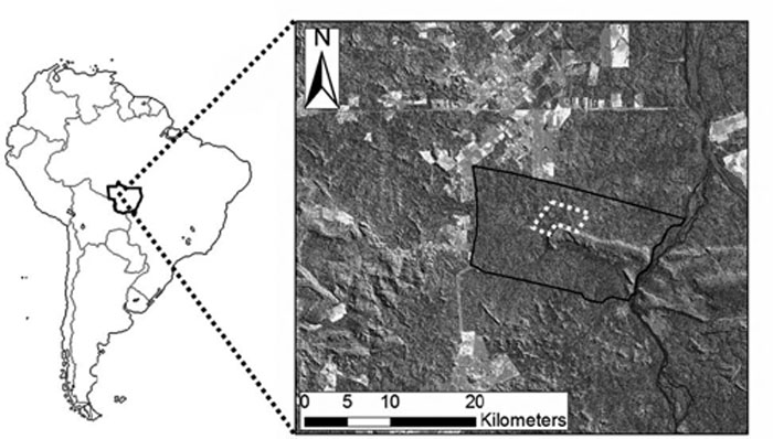
Figure 1. Study location in Juruena, Mato Grosso, Brazil. The 1400 ha study area outlined in dashed white line is situated within the 25,000 ha Fazenda Roshmar logging concession outlined in black on the LANDSAT image. The Juruena River is seen to the east of the study area. From Feldpausch et al., 2005.
Data Citation:
Cite this data set as follows:
Jirka S., T.R. Feldpausch, and S.J. Riha. 2010. LBA-ECO ND-11 Ecotone Vegetation Survey and Biomass, NW Mato Grosso, Brazil: 2004. Data set. Available on-line [http://daac.ornl.gov] from Oak Ridge National Laboratory Distributed Active Archive Center, Oak Ridge, Tennessee, U.S.A.doi: 10.3334/ORNLDAAC/964
Implementation of the LBA Data and Publication Policy by Data Users:
The LBA Data and Publication Policy [http://daac.ornl.gov/LBA/lba_data_policy.html] is in effect for a period of five (5) years from the date of archiving and should be followed by data users who have obtained LBA data sets from the ORNL DAAC. Users who download LBA data in the five years after data have been archived must contact the investigators who collected the data, per provisions 6 and 7 in the Policy.
This data set was archived in March of 2010. Users who download the data between March 2010 and February 2015 must comply with the LBA Data and Publication Policy.
Data users should use the Investigator contact information in this document to communicate with the data provider. Alternatively, the LBA Web Site [http://lba.inpa.gov.br/lba/] in Brazil will have current contact information.
Data users should use the Data Set Citation and other applicable references provided in this document to acknowledge use of the data.
Table of Contents:
- 1 Data Set Overview
- 2 Data Characteristics
- 3 Applications and Derivation
- 4 Quality Assessment
- 5 Acquisition Materials and Methods
- 6 Data Access
- 7 References
1. Data Set Overview:
Project: LBA (Large-Scale Biosphere-Atmosphere Experiment in the Amazon)
Activity: LBA-ECO
LBA Science Component: Nutrient Dynamics
Team ID: ND-11 (Lehmann / Passos / Couto)
The investigators were Lehmann, Johannes; Couto, Eduardo Guimaraes; Passos, Carlos Alberto Moraes; Abdo, Mara Silvia Aguiar; Botelho, Pericles de Aquino; Chig, Leo Adriano; Dias de Oliviera, Rodolfo; Feldpausch, Ted R.; Fernandes, Erick C.M.; Fhr, Silvana Ines; Gallardo Ordinola, Jorge Luis Enrique; Gandini, Elenara; Goncalves, Jose Francisco Carvalho; Jirka, Stefan; Johnson, Mark Stephen; Luizao, Flavio Jesus; Luizao, Regina C. C.; McDonald, Andrew J.; Morais, Ronaldo Ribeiro de; Noquelli, Maria Jose Miranda de Souza; Novaes Filho, Joao Paulo; Pauletto, Daniela; Riha, Susan J.; Rodrigues, Luiz Carlos Mattos; Santos, Ulysses Moreira; Sato, Shinjiro; Selva, Evandro Carlos; Silva, Carlos Eduardo Moura; Silva, Rubenildo; Silveira, Iracino Bomfim; Tomazi, Michely and Wittman, Hannah K. . You may contact Jirka, Stefan (stefanjirka@gmail.com)
LBA Data Set Inventory ID:ND11_Veg_Biomass_MT
Elucidating the factors that contribute to spatial dynamics in forest composition and structure can help inform forest management protocol, improve biomass estimates and explain controls on biocomplexity. In this study we analyzed the soil and landscape controls affecting forest attributes in the seasonally dry southwestern Amazon, Fazenda Roshmar logging concession in the municipality of Juruena, Mato Grosso. Three major forest types differentiated by tree species composition, biomass, soil type, and landscape position were identified: 1) campinarana; high stem density and low biomass on sandstone outcrops, 2) palm forest; low-lying seasonally inundated areas dominated by palms and, 3) terra firme; low stem density and high biomass. Using Landsat imagery and ground surveys, transition zones between eco-types were identified and six 10 x 100 m transects were established along transitions. Each vegetation type is represented by approximately two transects. Along these transects, all trees, palms and lianas >= 10 cm DBH in 10 x 10 m plots and, in nested 2 x 10 m subplots, all trees, palms and lianas >=1 cm DBH were measured, identified and georeferenced.
Related Data Sets:
- LBA-ECO ND-11 Pre-harvest Forest Tree and Liana Biomass, NW Mato Grosso, Brazil: 2003
- LBA-ECO ND-11 Regeneration in Undisturbed and Logged Forests, NW Mato Grosso, Brazil
- LBA-ECO ND-11 Forest Damage Following Reduced Impact Logging, NW Mato Grosso, Brazil
2. Data Characteristics:
Data were collected in a one time survey conducted in June and July 2004 at the Fazenda Roshmar logging concession in the municipality of Juruena, in the state of Mato Grosso. Vegetation survey data are reported in the comma separated ASCII file: ND11_Vegetation_Class_Transects_MT_2004.csv
Along each transect, GPS coordinates for 3-5 points were recorded for purposes of georeferencing the 10 x 10 m plots. These coordinates are reported in the comma separated ASCII file: ND11_Vegetation_Class_Transects_GIS_points.csv
Data File: ND11_Vegetation_Class_Transects_MT_2004.csv
| Column Number | Column Name | Units/format | Variable Description |
|---|---|---|---|
| 1 | Date | YYYY/MM/DD | Sampling date |
| 2 | Year | YYYY | Year sampled |
| 3 | Month | MM | Month sampled |
| 4 | Day | DD | Day sampled |
| 5 | ID | Identification number for each individual plant | |
| 6 | Transect | Transect number; transects are 10 x 100 m except for transect 7 which is 10 x 50 m | |
| 7 | Transect_type | Qualitative assessment of dominant of 3 vegetation types; pa=palm, tf=tierra firme, ca=campinarana | |
| 8 | Plot | Each 10 x 10 m plot along the transect was assigned a number in sequential order | |
| 9 | Subplot | Each plot was divided into two subplots: 1= is the first 2 x 10 m subplot and all stems >=1 cm DBH were measured; 2= the remaining 8 x 10 m subplot and all stems >=10 cm DBH were measured in this subplot. | |
| 10 | Section | Identifies both the plot and the subplot in the format plot.subplot | |
| 11 | X | m | Distance in meters (m) along the x (east-west) axis of the transect |
| 12 | Y | m | Distance in meters (m) along the y (north-south) axis of the transect |
| 13 | Health | Qualitative assessment of the individuals status a=alive, d=dead | |
| 14 | Life_form | Life form; t=tree, l=liana, p=palm, sp=stemless palm | |
| 15 | Common_name | Common name in Portuguese | |
| 16 | Scientific_name | Scientific name, genus and species, when available | |
| 17 | Family | Scientific family, when available | |
| 18 | DBH | cm | Diameter at breast height (cm); for lianas, 1.3 m from ultimate rooting point of all vines greater than 2 m height |
| 19 | Leaf_count | Number of full grown leaves for stemless palms ( DBH not measured for these individuals) | |
| 20 | Position | Position; s=standing, l=leaning, p=prone | |
| 21 | Branching_height | m | For trees, height to first major branch in meters (m). For palms, height to first leaf in meters (m). |
| 22 | Total_height | m | For trees, height to top of crown in meters (m). For palms, height to base of top leaf in meters (m). |
| 23 | Bifurcation_index | Bifurcation index; Total_height/Branching_height | |
| 24 | Canopy_position | Position of tree or palm relative to surrounding canopy; u=understory, d=dominant, e=emergent | |
| 25 | Dominant | For individuals with multiple stems that have a DBH greater than 1cm this is the id of the dominant individual | |
| 26 | Notes | Observations on individuals | |
| 27 | Transect_notes | Observations for the transect | |
| 28 | Basal_area | m2 | Basal area of the individual in meters squared (m2) calculated from the DBH |
| Missing data is represented by -9999 | |||
Example data record:
| Date,Year,Month,Day,ID,Transect,Transect_type,Plot,Subplot,Section,X,Y,Health,Life_form,Common_name, Scientific_name,Family,DBH,Leaf_count,Position,Branching_height,Total_height,Bifurcation_index,Canopy_position, Dominant,Notes,Transect_notes,Basal_area 2004/06/08,2004,6,8,1,2,pa,1,1,1.1,1.5,0.2,a,p,acai,Euterpe oleracea (Mart.),Arecaceae,3.2,-9999,s,2.4,3.3,0.727,u, -9999,None,None,0.0008 2004/06/08,2004,6,8,2,2,pa,1,1,1.1,9.5,0.5,a,t,canela,Ocotea sp.,Lauraceae,1.9,-9999,s,-9999,3,-9999,u,-9999,None,None,0.0003 2004/06/08,2004,6,8,3,2,pa,1,1,1.1,7.5,0.5,a,p,pataua,Oenocarpus bataua,Arecaceae,24.2,-9999,s,10.6,14.1,0.752,d,-9999,changed to dominant Canopy_position,None,0.046 ... 2004/07/17,2004,7,17,1303,7,pa,5,2,5.2,1.6,48,a,p,acai,Euterpe oleracea (Mart.),Arecaceae,14.5,-9999,s,-9999,17.7,-9999,d, -9999,None,None,0.0165 2004/07/17,2004,7,17,1304,7,pa,5,2,5.2,0.4,47.5,a,p,acai,Euterpe oleracea (Mart.),Arecaceae,15,-9999,s,-9999,18.7,-9999,d, -9999,None,None,0.0177 2004/07/17,2004,7,17,1305,7,pa,5,2,5.2,2.4,42.2,a,t,caixeta,Simarouba amara Aubl.,Simaroubaceae,71.3,-9999,s,-9999,35,-9999,e, -9999,None,None,0.3991 |
Data file: ND11_Vegetation_Class_Transects_GPS_Points.csv
| Column Number | Column Name | Units/format | Variable Description |
|---|---|---|---|
| 1 | ID_point | Unique identifier for each point | |
| 2 | Transect | Transect number | |
| 3 | X | m | Distance in meters (m) from transect origin along the east-west axis |
| 4 | Y | m | Distance in meters (m) from transect origin along the north-south axis |
| 5 | Easting | UTM | Point location in UTM coordinates, Zone 22S |
| 6 | Northing | UTM | Point location in UTM coordinates, Zone 22S |
| 7 | Elevation | masl | Elevation at sampling point in meters above sea level (masl) |
| 8 | Year | YYYY | Year (YYYY) sampled |
| 9 | Month | MM | Month (MM) sampled |
| 10 | Day | DD | Day (DD) sampled |
| 11 | Date | YYYY/MM/DD | Date sampled |
| 12 | Time | HH:MM | Time (HH:MM) sampled with GPS in local time (GMT - 5) based on the 24 hour clock |
Example data record:
| ID_point,Transect,X,Y,Easting,Northing,Elevation,Year,Month,Day,Date,Time P2M50E,2,0,50,336650,8842002,237.1,2004,6,7,2004/06/07,10:45 P2M80E,2,0,80,336637,8841977,218.3,2004,6,7,2004/06/07,10:57 P2M90E,2,0,90,336634,8841969,231.3,2004,6,10,2004/06/10,10:08 ... P6M0E,6,10,0,335187,8842167,243.6,2004,6,18,2004/06/18,11:57 P7M20S,7,10,50,336658,8842038,234.7,2004,7,7,2004/07/07,15:37 P7M0S,7,10,0,336636,8842062,221.7,2004,6,25,2004/06/25,11:57 |
Site boundaries: (All
latitude and longitude given in decimal degrees )
| Site (Region) | Westernmost Longitude | Easternmost Longitude | Northernmost Latitude | Southernmost Latitude | Geodetic Datum | |
|---|---|---|---|---|---|---|
| Mato Grosso - Juruena (Mato Grosso) | -58.75969 | -58.75969 | -10.42492 | -10.42492 | World Geodetic System, 1984 (WGS-84) |
Time period:
- The data set covers the period 2004/06/05 to 2004/07/20.
- Temporal Resolution: one time survey of vegetation
Platform/Sensor/Parameters measured include:
- VEGETATION SURVEY / HUMAN OBSERVER / FOREST COMPOSITION/VEGETATION STRUCTURE
- VEGETATION SURVEY / HUMAN OBSERVER / CANOPY CHARACTERISTICS
- VEGETATION SURVEY / HUMAN OBSERVER / VEGETATION SPECIES
- FIELD INVESTIGATION / STEEL MEASURING TAPE / PLANT CHARACTERISTICS
3. Data Application and Derivation:
Most data sets on biomass in tropical forests ignore life forms other than trees and frequently ignore trees with diameters less than 10 cm. Our information on the amount and distribution of biomass in these systems is thus systematically biased because it includes other life forms and small diameter trees. The data reported here can be used to analyze spatial distribution of plant species and plant life form as well as the distribution of biomass between trees, palms and vines in a tropical forest.
4. Quality Assessment:
There is some known error associated with the GPS waypoints on the order of 5-15 meters. Similarly the diameters reported have an associated error of 0.2 cm.
5. Data Acquisition Materials and Methods:
Three major forest types differentiated by tree species composition, biomass, soil type and landscape position were identified: 1) campinarana; high stem density and low biomass on sandstone outcrops, 2) palm forest; low-lying seasonally inundated areas dominated by palms and, 3) terra firme; low stem density and high biomass. Using Landsat imagery and ground surveys, transition zones between eco-types were identified and six 10 x 100 m transects were established along transitions. Each vegetation type is represented by approximately two 10 x 100 m transects. All trees, palms, and lianas >=10 cm DBH and, in nested 2 x 10 m plots, all trees, palms and lianas >=1 cm DBH were measured, identified and georeferenced. Table from Jirka et al. (2007).
| Transect | Dimension | Type | Position | Description |
|---|---|---|---|---|
| 2 | 10 x 100 m | Modal | Lowland | Palm-dominated forest located in a low-lying convergence zone |
| 3 | 10 x 100 m | Transition | Lowland | Transition from upland to palm-dominated scrub forest |
| 4 | 10 x 100 m | Transition | Upland | Transition from Oenocarpus bataua palm-dominated forest to campinarana |
| 5 | 10 x 100 m | Transition | Upland | Transition from upland to campinarana dominated by monospecific Attalea spec. palm stand |
| 6 | 10 x 100 m | Modal | Upland | Campinarana near edge of upland forest transition |
| 7 | 10 x 50 m | Modal | Upland | Upland forest near edge of palm-dominated transect 2 |
![]()
Schematic of the transects and plots within the study area. Note that this data set refers to "plots and subplots" rather than "subplots and sub sections".
6. Data Access:
This data is available through the Oak Ridge National Laboratory (ORNL) Distributed Active Archive Center (DAAC).
Data Archive Center:
Contact for Data Center Access Information:
E-mail: uso@daac.ornl.gov
Telephone: +1 (865) 241-3952
7. References:
Feldpausch TR, Jirka S, Passos CAM, et al. 2005. When big trees fall: Damage and carbon export by reduced impact logging in southern Amazonia. FOREST ECOLOGY AND MANAGEMENT 219: 2-3. 199-215.
Jirka,
S., McDonald, A.J., Johnson, M.S., Feldpausch, T.R., Couto, E.G., Riha,
S.J., 2007. Relationships between soil hydrology and forest structure
and composition inthe southern Brazilian Amazon. Journal of Vegetation
Science 18, 183–194. doi:10.1111/j.1654-1103.2007.tb02529.x
Related Publications
- Jirka, S. 2006. Plant-environment associations and forest structure in the southern Amazon basin. Thesis. Cornell University.