Summary:
This data set provides a time series of Landsat Multispectral Scanner (MSS), Thematic Mapper (TM), and Enhanced Thematic Mapper Plus (ETM+) scenes for five (Path/Row) areas in Rondonia, Brazil. The scenes are from the period June 1975 through June 2000, but all areas do not have scenes for all the years.
The areas and Landsat Path/Rows included are as follows: Ariquemes (P232,R67), Ji-Parana (P231, R67), Luiza (P231, R68), Cacoal (P230, R68), and Porto Velho (P232, R66). TM images are available for all five areas. Because of a paucity of digital Landsat MSS imagery from the 1970s, only two scenes could be included, a 1975 scene from Ariquemes and a 1978 scene from Ji-Parana.
Each of the Landsat scenes has been coregistered to a Path/Row-specific georectified PRODES Landsat file obtained from the Brazilian Government's National Institute for Space Research (INPE) program. For each scene, the coregistration is accurate to within (plus or minus)1 pixel (30-m Landsat resolution) in most places.
The five INPE PRODES Landsat scenes used in the georectification process are included with this data set.
There are five compressed files (tar.gz format) with this data set. When expanded, each compressed file (which corresponds to one of the five areas) contains a directory for each scene with GeoTIFF files for individual Landsat bands, a text file of tie points, and another text file of slope and intercept values for converting radiance to reflectance. There are two dates for Landsat MSS scenes, 45 dates for TM scenes, and six dates for ETM+ scenes.
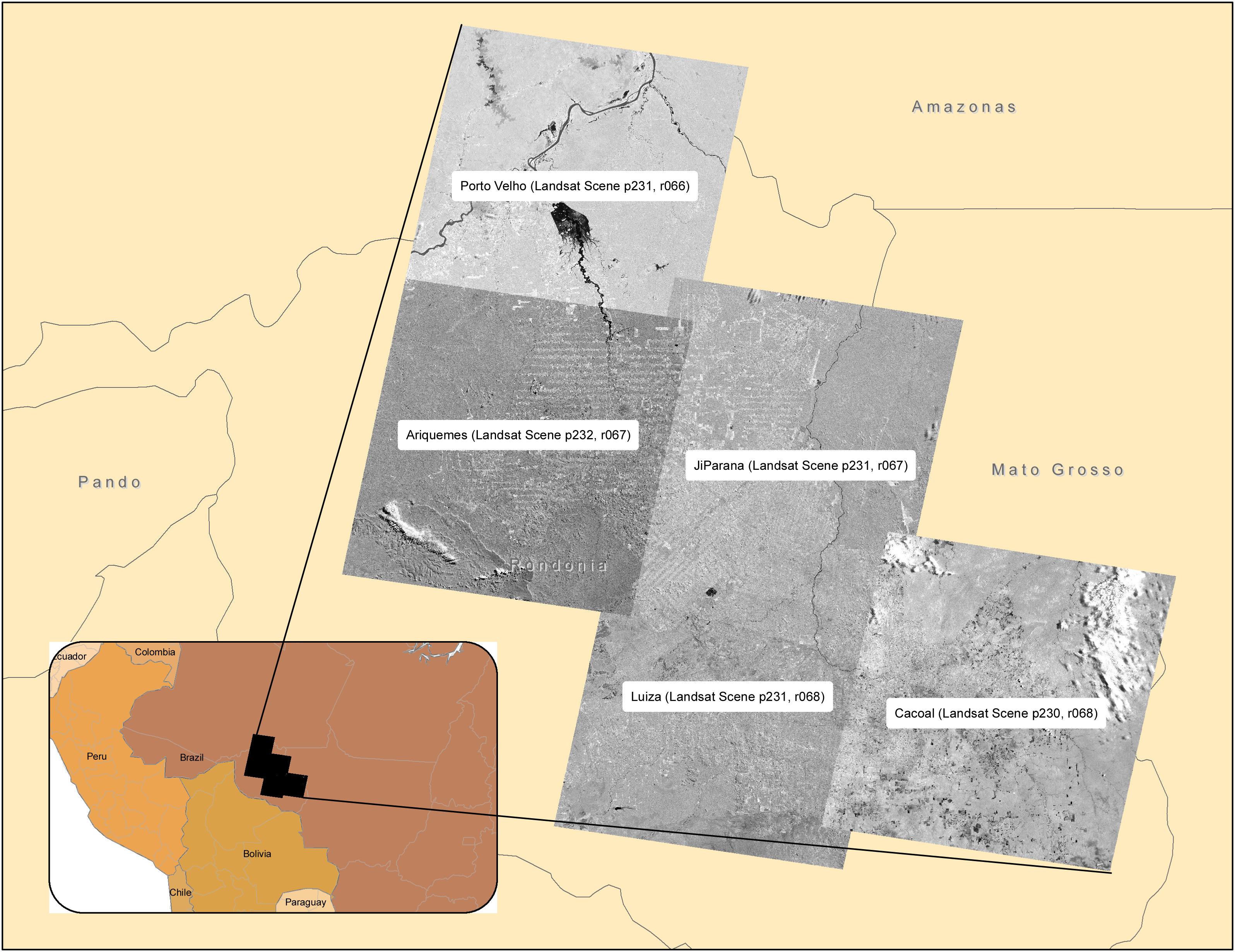
Figure 1. The five Brazilian sites and corresponding Landsat scenes in this data set.
Data Citation:
Cite this data set as follows:
Roberts, D.A., I. Numata, K.W. Holmes, G.T. Batista, T. Krug, A.L. Monteiro, B. Powell, and O.A. Chadwick. 2013. LBA-ECO ND-01 Georegistered Landsat Imagery for Rondonia, Brazil: 1975-2000. Data set. Available on-line [http://daac.ornl.gov] from Oak Ridge National Laboratory Distributed Active Archive Center, Oak Ridge, Tennessee, USA. http://dx.doi.org/10.3334/ORNLDAAC/1197
Implementation of the LBA Data and Publication Policy by Data Users:
The LBA Data and Publication Policy [http://daac.ornl.gov/LBA/lba_data_policy.html] is in effect for a period of five (5) years from the date of archiving and should be followed by data users who have obtained LBA data sets from the ORNL DAAC. Users who download LBA data in the five years after data have been archived must contact the investigators who collected the data, per provisions 6 and 7 in the Policy.
This data set was archived in November of 2013. Users who download the data between November 2013 and October 2018 must comply with the LBA Data and Publication Policy.
Data users should use the Investigator contact information in this document to communicate with the data provider.
Data users should use the Data Set Citation and other applicable references provided in this document to acknowledge use of the data.
Table of Contents:
- 1 Data Set Overview
- 2 Data Description
- 3 Applications and Derivation
- 4 Quality Assessment
- 5 Acquisition Materials and Methods
- 6 Data Access
- 7 References
1. Data Set Overview:
Project: LBA (Large-Scale Biosphere-Atmosphere Experiment in the Amazon)
Activity: LBA-ECO
LBA Science Component: Land Use and Land Cover
Team ID: ND-01 (Chadwick / Roberts / Batista)
TThe investigators were Chadwick, Oliver A.; Roberts, Dar A.; Batista, Getulio T.; Biggs, Trent W.; Gessler, Paul E.; Holmes, Karen W. and Tomasella, Javier. You may contact Roberts, Dar A. (dar@geog.ucsb.edu).
LBA Data Set Inventory ID: ND01_Registered_TM_MSS_Rondonia
This data set provides a time series of Landsat Multispectral Scanner (MSS), Thematic Mapper (TM), and Enhanced Thematic Mapper Plus (ETM+) scenes for five (Path/Row) areas in Rondonia, Brazil. The scenes are from the period June 1975 through June 2000, but all areas do not have scenes for all the years.
The areas and Landsat Path/Rows included are as follows: Ariquemes (P232,R67), Ji-Parana (P231, R67), Luiza (P231, R68), Cacoal (P230, R68), and Porto Velho (P232, R66). TM images are available for all five areas. Because of a paucity of digital Landsat MSS imagery from the 1970s, only two scenes could be included, a 1975 scene from Ariquemes and a 1978 scene from Ji-Parana.
Each of the Landsat scenes has been coregistered to a Path/Row-specific georectified PRODES Landsat file obtained from the Brazilian Government's National Institute for Space Research (INPE) program. For each scene, the coregistration is accurate to within (plus or minus) 1 pixel (30-m Landsat resolution) in most places.
The five INPE PRODES Landsat scenes used in the georectification process are included with this data set.
Related Data Sets:
- LBA-ECO ND-01 Fractional Land Cover Images, Rondonia, Brazil: 1984-2000 (Land cover classification maps for the five sites)
- LBA-ECO ND-01 Landsat 28.5-m Land Cover Time Series, Rondonia, Brazil: 1984-2010 (land cover time series derived from Landsat Images for Rondonia, Brazil)
2. Data Characteristics:
There are five compressed files (tar.gz format) with this data set. These files contain directories which correspond to the five Brazilian locations. The locations (with the corresponding Landsat path/row) are labelled as: ariquemes (P232, R67), cacoal (P230, R68), jiparana (P231, R67), luiza (P231, R68), and portovelho (P232, R66). Each Landsat area also includes the INPE PRODES Landsat scene used in the georectification process.
There were several acquisition dates for each Landsat scene covering the time period 1975 - 2000. Each date contains several files including GeoTIFFS (.tif), a metadata file for each Landsat band (.xml), a text file of tie points (.pts), and a text file of slope/intercept values (.go). A PRODES folder is included for each area which contains the INPE PRODES base image to which all other scenes for that location were registered.
Five compressed files:
ND01_Registered_TM_MSS/data/ariquemes.tar.gz
ND01_Registered_TM_MSS/data/cacoal.tar.gz
ND01_Registered_TM_MSS/data/jiparana.tar.gz
ND01_Registered_TM_MSS/data/luiza.tar.gz
ND01_Registered_TM_MSS/data/portovelho.tar.gz
File naming convention:
For each Landsat scene there were several acquisition dates, and the files are named with a two letter abbreviation of the site followed by the acqusition date and band number.
For each date, the following files are included:
*.tif -- geotif file for each registered Landsat single band image.
There are multiple files of individual Landsat bands per scene
designated within the filename by *.b1 - *.b7 respectively.
*.aux.xml -- GeoTIFF metadata file
*.pts -- a text file of tie points used to warp the raw image data to a registered PRODES data set
*.go -- a text file of slope and intercept values for the linear equation to convert radiance to reflectance
Example file names:
ar000628.b4.reg.tif: a tif file for the Ariquemes location (P232, R67) acquired on June 28, 2000.
ar000628.b5.reg.tif.aux.xml: GeoTIFF metadata file for the arquemes location acquired on June 28, 2000.
ar00to99p.pts: a text file of tie points used to warp the raw image data to a registered PRODES data set.
ar000628.go: a text file of slope and
intercept values for the linear equation to convert radiance to reflectance.
The following Landsat Scenes and ancillary data are available for each of the 5 locations:
Ariquemes: 16 acquisition dates for Landsat Path 232, Row 67
ar000628
ar75
ar840624
ar860801mss
ar880721
ar890724
ar900812
ar910612
ar920622
ar931007
ar940604
ar950725
ar960711
ar970628
ar980717
ar991016
PRODES/
Cacoal: Eight acquisition dates for Landsat Path 230, Row 68
ca880808
ca890912
ca920710
ca940809
ca960713
ca961017
ca980719
ca990815
PRODES/
JiParana: 11 acquisition dates for Landsat Path 231, Row 67
ji78
ji861013
ji880730
ji890802
ji900805
ji930728
ji960720
ji960922
ji970621
ji980608
ji990806
PRODES/
Luiza:10 acquisition dates for Landsat Path 231, Row 68
lu861013mss
lu861013
lu880730
lu890802
lu900805
lu920725
lu950803
lu960720
lu970723
lu990806
PRODES/
Portovelho: Eight acquisition dates for Landsat Path 232, Row 66
pv000628
pv860716
pv881001
pv920724
pv931007
pv960626
pv970628
pv980717
PRODES/
Spatial Data Properties
All GeoTIFF files for this dataset have the same basic Spatial Data Properties. The row/column and spatial extent differences are listed below for each of the 5 areas.
Spatial Representation Type: Raster
Pixel Depth: 8 bit
Compression Type: LZW
Number of Bands: 1
Band Information: Landsat Band
Raster Format: TIFF
Source Type: continuous
Pixel Type: unsigned integer
No Data Value: none
Ariquemes (Landsat Path 232, Row 67)
Number Columns: 7881
Column Resolution: 30 m
Number Rows: 7368
Row Resolution: 30 m
Extent in the items coordinate system
North: 8990040.915
South: 8769000.915
West: 309476.996
East: 545906.996
Cell geometry: area
Point in pixel: center
Cacoal (Landsat Path 230, Row 68)
Number Columns: 7914
Column Resolution: 30 m
Number Rows: 7388
Row Resolution: 30 m
Extent in the items coordinate system
North: 8830168.000
South: 8608528.000
West: 613266.000
East: 850686.000
Cell geometry: area
Point in pixel: center
Jiparana (Landsat Path 231, Row 67)
Number Columns: 7877
Column Resolution: 30 m
Number Rows: 7373
Row Resolution: 30 m
Extent in the items coordinate system
North: 8990876.700
South: 8769686.700
West: 479838.600
East: 716148.600
Cell geometry: area
Point in pixel: center
Cell geometry: area
Point in pixel: center
Luiza (Landsat Path 231, Row 68)
Number Columns: 7818
Column Resolution: 30 m
Number Rows: 7365
Row Resolution: 30 m
Extent in the items coordinate system
North: 8830071.600
South: 8609121.600
West: 446225.000
East: 680765.000
Cell geometry: area
Point in pixel: center
Portovelho (Landsat Path 232, Row 66)
Number Columns: 7874
Column Resolution: 30 m
Number Rows: 7357
Row Resolution: 30 m
Extent in the items coordinate system
North: 9150358.000
South: 8929648.000
West: 344227.000
East: 580447.000
Cell geometry: area
Point in pixel: center
Spatial Reference Properties
The spatial reference information is the same for each Landsat scene.
Type: Projected
Geographic Coordinate Reference: GCS_SAD69
Projection: UTM_Zone_20_Southern_Hemisphere
Open Geospatial Consortium (OGC) Well Known Text (WKT)
PROJCS["UTM_Zone_20_Southern_Hemisphere",
GEOGCS["GCS_SAD69",
DATUM["D_South_American_1969",
SPHEROID["GRS_1967",6378160.0,298.2471674269971]],
PRIMEM["Greenwich",0.0],
UNIT["Degree",0.0174532925199433]],
PROJECTION["Transverse_Mercator"],
PARAMETER["false_easting",500000.0],
PARAMETER["false_northing",10000000.0],
PARAMETER["central_meridian",-63.0],
PARAMETER["scale_factor",0.9996],
PARAMETER["latitude_of_origin",0.0],
UNIT["Meter",1.0]]
Table of Landsat MSS and TM scene dates for the five sites:
| Year | Ariquemes | Ji Parana | Luiza | Cacoal | Porto Velho | Type: MSS or TM |
|---|---|---|---|---|---|---|
| 1975 | 19750619 | MSS* | ||||
| 1978 | 197808x | MSS** | ||||
| 1984 | 19840624 | TM | ||||
| 1986 | 19860801 | 19861013 | 19861013 19861013MSS |
19860716 | TM | |
| 1988 | 19880721 | 19880730 | 19880730 | 19880808 | 19881001 | TM |
| 1989 | 19890724 | 19890802 | 19890802 | 19890912 | TM | |
| 1990 | 19900812 | 19900805 | 19900805 | TM | ||
| 1991 | 19910621 | TM | ||||
| 1992 | 19920622 | 19920725 | 19920710 | 19920724 | TM | |
| 1993 | 19931007 | 19930728 | 19931007 | TM | ||
| 1994 | 19940604 | 19940809 | TM | |||
| 1995 | 19950725 | 19950803 | TM | |||
| 1996 | 19960711 | 19960922 19960722 |
19960720 | 19960713 19961013 |
19960626 | TM |
| 1997 | 19970628 | 19970621 | 19970723 | 19970628 | TM | |
| 1998 | 19980717 | 19970608 | 19980719 | 19980717 | TM | |
| 1999 | 19991016 | 19990806 | 19990806 | 19990815 | ETM | |
| 2000 | 20000628 | 20000628 | ETM |
Notes:
WRS-1,P249, R67
WRS-1,P248, R67
Notes regarding specific locations / scenes:
Ariquemes, Rondonia, Registered TM:
- Temporal Coverage: 1984-2000
- Begin: 19840624 - End: 20000628
- Platform: Landsat-5
Special notes:
- 1999 scene was severely cloud contaminated.
- Collection includes Landsat ETM for 2000
Ariquemes, Rondonia, Registered MSS:
- Temporal Coverage: 1975-06-19
- Platform: There is some uncertainty whether these Landsat images were Landsat-1 or Landsat-2
Special notes: none.
JiParana, Rondonia, Registered TM:
Temporal Coverage: 1986-1999
- Begin: 19861013 - End: 19990806
Platform: Landsat-5
Special notes:
- Lower portions of TM3 in 1993 were corrupted. Lower portion of TM3 was estimated
by developing a relationship between TM3 and all other bands for the upper half of the image.
- Includes Landsat ETM for 1999.
JiParana, Rondonia, Registered MSS:
Temporal Coverage: 1978-08-01
Platform: Landsat-2
Special notes:
- Exact day within August 1978 unknown; August 1 selected arbitrarily.
Cacoal, Rondonia, Registered TM:
Temporal Coverage: 1988-1999
- Begin: 19880808 - End: 19990815
Platform: Landsat-5
Special notes: none.
Luiza, Rondonia, Registered TM:
Temporal Coverage: 1986-1999
- Begin: 19861013 - End: 19990806
Platform: Landsat-5
Special notes: none.
Portovelho, Rondonia, Registered TM:
Temporal Coverage: 1986-2000
- Begin: 19860716 - End: 20000628
Platform: Landsat-5
Special notes:
- Collection includes Landsat ETM for 2000.
Landsat data were originally obtained from Woods Hole Research Center, Woods Hole, Massachusetts.
Site boundaries: (All latitude and longitude given in decimal degrees)
| Site (Region) | Westernmost Longitude | Easternmost Longitude | Northernmost Latitude | Southernmost Latitude | Geodetic Datum |
|---|---|---|---|---|---|
| Rondonia - Ariquemes (Rondonia) | -64.64056 | -62.69722 | -9.18083 | -11.07528 | South-American Datum, 1969 (SAD-69) |
| Rondonia - Cacoal (Rondonia) | -61.88907 | -59.85667 | -10.65794 | -12.49684 | South-American Datum, 1969 (SAD-69) |
| Rondonia - Ji Parana (Rondonia) | -63.06833 | -61.18167 | -9.36861 | -10.93583 | South-American Datum, 1969 (SAD-69) |
| Rondonia - Luiza (Rondonia) | -63.40667 | -61.48278 | -10.6975 | -12.43111 | South-American Datum, 1969 (SAD-69) |
| Rondonia - PortoVelho (Rondonia) | -64.28306 | -62.44778 | -7.8275 | -9.51889 | South-American Datum, 1969 (SAD-69) |
Time period:
- The data set covers the period 1975/06/19 to 2000/06/28.
- Temporal Resolution: Multiple scenes are available at every site at erratic intervals. See table provided for dates available for each site.
Platform/Sensor/Parameters measured include:
- LANDSAT-5 (LAND REMOTE-SENSING SATELLITE-5) / LANDSAT TM (LANDSAT THEMATIC MAPPER) / VISIBLE IMAGERY
- LANDSAT-5 (LAND REMOTE-SENSING SATELLITE-5) / LANDSAT ETM+ / VISIBLE IMAGERY
- LANDSAT-5 (LAND REMOTE-SENSING SATELLITE-5) / LANDSAT TM (LANDSAT THEMATIC MAPPER) / INFRARED IMAGERY
- LANDSAT-2 (LAND REMOTE-SENSING SATELLITE-2) / MSS (MULTISPECTRAL SCANNER) / VISIBLE IMAGERY
- LANDSAT-2 (LAND REMOTE-SENSING SATELLITE-2) / MSS (MULTISPECTRAL SCANNER) / INFRARED IMAGERY
3. Data Application and Derivation:
Typical application of the data: These images may be used cartographically, as base data upon which other spatial data layers are displayed. Additionally, the data may be used to derive LULC classifications that may be used to calculate deforestation rates or pattern metrics, as well as to produce change detections.
4. Quality Assessment:
Horizontal Accuracy: MSS Images that have been geo-rectified all have a horizontal accuracy of plus or minus one pixel. TM and ETM Images that have been geo-rectified all have a horizontal accuracy of plus or minus one pixel
5. Data Acquisition Materials and Methods:
Two Landsat MSS scenes, 45 TM scenes, and six ETM+ scenes were assembled into a comprehensive time series for five areas:
Ariquemes (P232, R67), Ji-Parana (P231, R67), Luiza (P231, R68), Cacoal (P230, R68), and Porto Velho (P232, R66). Because of a paucity of digital Landsat MSS from the 1970s, only two early scenes could be included, a 1975 scene from Ariquemes and a 1978 scene from Ji-Parana.
The best temporal coverage was obtained for Ariquemes, which, in addition to a 1975 scene, included fifteen TM scenes, one from 1984, and annual coverage from 1988 to 1999.
All Landsat data were coregistered to 1998 or 1999 georectified digital PRODES data supplied by the Instituto Nacional de Pesquisas Espaciais [INPE, 2000]. PRODES is an INPE project which utilizes Landsat data and digital analysis to monitor tropical forest deforestation. The Digital PRODES data were considered by INPE collaborators to have the highest quality spatial accuracy and thus were chosen for a base map.
Landsat data were georectified using between 30 and 40 tie points and rubber sheet stretching. All images were resampled using nearest neighbor resampling.
Landsat MSS data were originally obtained from Woods Hole Research Center, Woods Hole, Massachusetts. Landsat TM data were obtained from various sources, including INPE.
6. Data Access:
This data set is available through the Oak Ridge National Laboratory (ORNL) Distributed Active Archive Center (DAAC).
Data Archive Center:
E-mail: uso@daac.ornl.gov
Telephone: +1 (865) 241-3952
7. References:
INPE, 2000. Monitoramento da floresta Amazonica Brasileira por satelite 1998-1999, 22 pp., Inst. Nac. de Pesqui. Espaciais, Sao Jose Dos Campos SP, Brazil.
Related Publications
- Holmes, K.W., D.A. Roberts, S. Sweeney, I. Numata, E. Matricardi, T.W. Biggs, G. Batista, and O.A. Chadwick. (2004) Soil databases and the problem of establishing regional biogeochemical trends. Global Change Biology 10(5):796-814.
- Roberts, D.A., I. Numata, K. Holmes, G. Batista, T. Krug, A. Monteiro, B. Powell, and O.A. Chadwick. 2002. Large area mapping of land-cover change in Rondonia using multitemporal spectral mixture analysis and decision tree classifiers. Journal of Geophysical Research-Atmospheres 107(D20): Article-8073.
- Souza, C.M.J., D.A. Roberts, and A.L. Monteiro. 2005. Multitemporal Analysis of Degraded Forests in the Southern Brazilian Amazon. Earth Interactions 9(19):1-25.