Summary:
This data set provides annual spatial patterns of cropland, natural pasture, and planted pasture land uses across Amazonia for the period 1940/1950-1995. Two series of 5-minute grid cell historical maps were generated starting from land use classification products for 1995. Annual data are the fraction of natural pasture, planted pasture, and cropland in each 5-min grid cell.
The annual maps are provided in two NetCDF (.nc) format file at 5-minute resolution. The AMZ-C.nc file covers the Brazilian portion of Amazon and Tocantins Rivers basins, and is based on the 1995 land use classification of Cardille et al. (2002), generated through the fusion of remote sensing (AVHRR) and agricultural census data. The second file, AMZ-R.nc, covers the entire Legal Amazon region and adjacent areas and is based on the 1995 land use classification by Ramankutty et al. (2008). The land use classification was generated by the fusion of satellite imagery (MODIS and VEGETATION-SPOT) and data from the agricultural census. A historical land-use reconstruction algorithm was used to generate the annual spatial patterns (based on work from Ramunkutty and Foley, 1999).
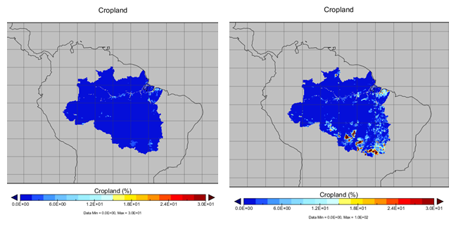
Figure 1. Cropland fractional cover for years 1940 (left) and 1995 (right).
Data Citation:
Cite this data set as follows:
Leite, C. C. and Costa, M. H. 2013. LBA-ECO LC31 Historical Land-Use in the Amazon: 1940-1995. Data set. Available on-line [http://daac.ornl.gov] from Oak Ridge National Laboratory Distributed Active Archive Center, Oak Ridge, Tennessee, U.S.A. http://dx.doi.org/10.3334/ORNLDAAC/1170
Implementation of the LBA Data and Publication Policy by Data Users:
The LBA Data and Publication Policy [http://daac.ornl.gov/LBA/lba_data_policy.html] is in effect for a period of five (5) years from the date of archiving and should be followed by data users who have obtained LBA data sets from the ORNL DAAC. Users who download LBA data in the five years after data have been archived must contact the investigators who collected the data, per provisions 6 and 7 in the Policy.
This data set was archived in June 2013. Users who download the data between June 2013 and May 2018 must comply with the LBA Data and Publication Policy.
Data users should use the investigator contact information in this document to communicate with the data provider.
Data users should use the Data Set Citation and other applicable references provided in this document to acknowledge use of the data.
Table of Contents:
- 1 Data Set Overview
- 2 Data Characteristics
- 3 Applications and Derivation
- 4 Quality Assessment
- 5 Acquisition Materials and Methods
- 6 Data Access
- 7 References
1. Data Set Overview:
Project: LBA (Large-Scale Biosphere-Atmosphere Experiment in the Amazon)
Activity: LBA-ECO
LBA Science Component: Land Use and Land Cover
Team ID: LC-31 (Foley / Costa)
The investigators were Costa, Marcos; Foley, Jonathan A.; Coe, Michael T; Gibbs, Holly; Howard, Erica Akiko; Leite, Christiane Cavalcante; Lima, Francisca Zenaide de; Senna, Monica Carneiro Alves and Zaks, David. You may contact Leite, Christiane Cavalcante (ccleite@gmail.com).
LBA Data Set Inventory ID: LC31_AMZ_HISTORICAL_LU
This data set provides annual spatial patterns of cropland, natural pasture, and planted pasture land uses across Amazonia for the period 1940/1950-1995. Two series of 5-minute grid cell historical maps were generated starting from land use classification products for 1995. Annual data are the fraction of natural pasture, planted pasture, and cropland in each 5-min grid cell.
The annual maps are provided in two NetCDF (.nc) format file at 5-minute resolution. The AMZ-C.nc file covers the Brazilian portion of Amazon and Tocantins Rivers basins, and is based on the 1995 land use classification of Cardille et al. (2002), generated through the fusion of remote sensing (AVHRR) and agricultural census data. The second file, AMZ-R.nc, covers the entire Legal Amazon region and adjacent areas and is based on the 1995 land use classification by Ramankutty et al. (2008). The land use classification was generated by the fusion of satellite imagery (MODIS and VEGETATION-SPOT) and data from the agricultural census. A historical land-use reconstruction algorithm was used to generate the annual spatial patterns (based on work from Ramunkutty and Foley, 1999).
Related Data Set:
Cardille, J.A., J.A. Foley, and M.H. Costa. 2008. LBA-ECO LC-04 Satellite/Census-Based 5-Minute Land Use Data, Amazonia: 1980 and 1995. Data set. Available on-line [http://daac.ornl.gov] from Oak Ridge National Laboratory Distributed Active Archive Center, Oak Ridge, Tennessee, U.S.A.doi: 10.3334/ORNLDAAC/906.
This is the 1995 land use classification of Cardille et al. (2002).
2. Data Characteristics:
Data are reported in two NetCDF files: AMZ-C.nc and AMZ-R.nc.
Each file contains the yearly fraction in each 5-min grid cell of natural pasture, planted pasture, and cropland starting, respectively, in 1950, 1950, and 1940 and all ending in 1995. Totaled combinations of these land-use types are also provided.
1) File AMZ-C.nc contains the Brazilian portion of Amazon and Tocantins Rivers basins.
2) File AMZ-R.nc covers the entire Legal Amazon region and adjacent areas.
Site boundaries: (All latitude and longitude given in decimal degrees)
| Site (Region) | Westernmost Longitude | Easternmost Longitude | Northernmost Latitude | Southernmost Latitude | Geodetic Datum |
|---|---|---|---|---|---|
| Amazonia (Brazilian portion of the Amazonas and Tocantins Rivers Basins) | -74.35 | -45.64 | 5.36 | -19.56 | South-American Datum, 1969 (SAD-69) |
| Amazonia (Legal Amazonia) | -74.35 | -45.59 | 5.41 | -19.56 | South-American Datum, 1969 (SAD-69) |
Time period:
- The data set covers the period 1940/01/01 to 1995/12/31.
- Temporal Resolution: annual
Platform/Sensor/Parameters measured include:
- SATELLITES / AVHRR (ADVANCED VERY HIGH RESOLUTION RADIOMETER) / LAND USE CLASSES
- SATELLITES / MODIS (MODERATE-RESOLUTION IMAGING SPECTRORADIOMETER) / AGRICULTURAL LANDS
- SPOT-4 (SYSTEME PROBATOIRE POUR L'OBSERVATION DE LA TERRE-4) / SPOT MULTISPECTRAL / LAND USE CLASSES
3. Data Application and Derivation:
This land use historical data can be used as input to climate and hydrology models to help understand the causes of hydroclimatic changes in Amazonia, as well as in the investigation of the impacts of the historical changes in land cover and land use in the water resources and carbon balance in Amazon.
4. Quality Assessment:
Pixel-level data is considerably uncertain, although regional patterns are well validated against Landsat imagery.
Remote sensing satellites can only observe land cover, i.e., the top of the vegetative canopy, and have little information on what happens below the canopy. The ground-based land use data may include different information from that captured by remote-sensing. For example, the cropland census data include permanent crops such as tree crops. It is not clear whether the remote sensing observations consider tree crops as tree cover or whether they classified them as cropland (Ramankutty et al., 2008).
Census data may not have made a distinction between grazing on grasslands, forests, and bare ground (Ramankutty et al., 2008).
5. Data Acquisition Materials and Methods:
AMZ-C data: AMZ-C data were derived from municipal level data, and a land use classification product for 1995 developed by Cardille et al. (2002)., developed through the fusion of agricultural census data and images derived from the AVHRR sensor. The data were used as an initial condition in a simple model of historical reconstruction of land use that used historical agricultural census data as input.
AMZ_R data: AMZ_R data were derived from municipal level data, and a land use classification product for 1995 developed by Ramankutty et al. (2008), developed through the fusion of agricultural census data, and images derived from the MODIS and VEGETATION-SPOT sensors.
A historical land-use reconstruction algorithm was used to generate the annual spatial patterns (based on work from Ramunkutty and Foley, 1999).
6. Data Access:
This data is available through the Oak Ridge National Laboratory (ORNL) Distributed Active Archive Center (DAAC).
Data Archive Center:
Contact for Data Center Access Information:
E-mail: uso@daac.ornl.gov
Telephone: +1 (865) 241-3952
7. References:
Cardille, J. A., J. A. Foley, and M. H. Costa (2002). Characterizing patterns of agricultural land use in Amazonia by merging satellite classifications and census data, Global Biogeochem. Cycles, 16(3), 1045, doi:10.1029/2000GB001386.
Ramankutty, N., A. T. Evan, C. Monfreda, and J. A. Foley (2008). Farming the planet: 1. Geographic distribution of global agricultural lands in the year 2000, Global Biogeochem. Cycles, 22, GB1003, doi:10.1029/2007GB002952.
Ramankutty, N., and J. A. Foley (1999), Estimating historical changes in global land cover: Croplands from 1700 to 1992, Global Biogeochem.Cycles, 13, 997– 1027.