Get Data
Summary:
This data set contains proportional estimates for the vegetative cover types of tree cover, herbaceous vegetation, and bare ground over South America for the period 2000-2001. These products were derived from all seven bands of the Moderate-resolution Imaging Spectroradiometer (MODIS) sensor onboard NASA's Terra satellite. A set of 500-m MOD09A1 Surface Reflectance 8-day minimum blue reflectance composites were used as input data. To reduce the presence of cloud shadows, the data were converted to 40-day composites using a second darkest albedo (sum of blue, green, and red bands), and the Vegetation Continuous Fields (VCF) algorithmn was utilized (Hansen et al., 2002). The VCF shows how much of a land cover such as "forest" or "grassland" exists anywhere on the land surface. The VCF product may depict areas of heterogeneous land cover better than traditional discrete classification schemes which shows where land cover types are concentrated.
There are three images provided in GeoTIFF format.
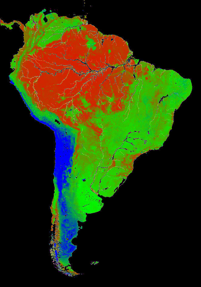
Figure 1. Percent land cover map of South America in three components: tree canopy cover (red), herbaceous and shrub cover (green), and bare ground (blue).
Data Citation:
Cite this data set as follows:
Hansen, M., R. DeFries, J.R. Townshend, M. Carroll, C. Dimiceli and R. Sohlberg. 2012. LBA-ECO LC-22 Vegetation Cover Types from MODIS, 500-m, South America: 2000-2001. Data set. Available on-line [http://daac.ornl.gov] from Oak Ridge National Laboratory Distributed Active Archive Center, Oak Ridge, Tennessee, U.S.A. http://dx.doi.org/10.3334/ORNLDAAC/1112
Intellectual Property Rights: University of Maryland; Department of Geography; use is free to all if citation is indicated as source. UMD holds ultimate copyright.
Implementation of the LBA Data and Publication Policy by Data Users:
The LBA Data and Publication Policy [http://daac.ornl.gov/LBA/lba_data_policy.html] is in effect for a period of five (5) years from the date of archiving and should be followed by data users who have obtained LBA data sets from the ORNL DAAC. Users who download LBA data in the five years after data have been archived must contact the investigators who collected the data, per provisions 6 and 7 in the Policy.
This data set was archived in August of 2012. Users who download the data between August 2012 and July 2017 must comply with the LBA Data and Publication Policy.
Data users should use the Investigator contact information in this document to communicate with the data provider. Alternatively, the LBA website [http://lba.inpa.gov.br/lba/] in Brazil will have current contact information.
Data users should use the Data Set Citation and other applicable references provided in this document to acknowledge use of the data.
Table of Contents:
- 1 Data Set Overview
- 2 Data Characteristics
- 3 Applications and Derivation
- 4 Quality Assessment
- 5 Acquisition Materials and Methods
- 6 Data Access
- 7 References
1. Data Set Overview:
Project: LBA (Large-Scale Biosphere-Atmosphere Experiment in the Amazon)
Activity: LBA-ECO
LBA Science Component:Land Use-Land Change
Activity: MODIS Land Science Team
Team ID: LC-22 (DeFries / Shimabukuro)
The investigators were Townshend, John R.; DeFries-Bajpai, Ruth; Sohlberg, Rob; Hansen, Matthew C.; Dimiceli, Charlene; Carroll, Mark; Semeiks, Bethany and Eastman, Jill. You may contact DeFries-Bajpai, Ruth (rdefries@geog.umd.edu).
LBA Data Set Inventory ID: LC22_MODIS_Tree_Cover
This data set contains proportional estimates for the vegetative cover types of tree cover, herbaceous vegetation, and bare ground over South America for the period 2000-2001. These products were derived from all seven bands of the Moderate-resolution Imaging Spectroradiometer (MODIS) sensor onboard NASA's Terra satellite. A set of 500-m MOD09A1 Surface Reflectance 8-day minimum blue reflectance composites were used as input data. To reduce the presence of cloud shadows, the data were converted to 40-day composites using a second darkest albedo (sum of blue, green, and red bands), and the Vegetation Continuous Fields (VCF) algorithmn was utilized (Hansen et al., 2002). The VCF shows how much of a land cover such as "forest" or "grassland" exists anywhere on the land surface. The VCF product may depict areas of heterogeneous land cover better than traditional discrete classification schemes which shows where land cover types are concentrated.
Related data set:
- Hansen, M.C., R.S. DeFries, J.R.G. Townshend, M. Carroll, C. Dimiceli, R.A. Sohlberg, and S.S. Saatchi. 2011. LBA-ECO LC-15 Vegetation Cover Types from MODIS, 1-km, Amazon Basin: 2000-2001. Data set. Available on-line [http://daac.ornl.gov] from Oak Ridge National Laboratory Distributed Active Archive Center, Oak Ridge, Tennessee, U.S.A. http://dx.doi.org/10.3334/ORNLDAAC/1035 (Similarly derived products differing in resolution and spatial extent.)
2. Data Characteristics:
The are three image files with this data set in GeoTIFF format. The images
represent percent tree cover, percent herbaceous ground cover and percent
bare ground cover over South America.
This product is an annual representation of percent tree cover for the
period from Nov. 2000 to Nov. 2001 and will be generated annually from one
year's worth of data.
The three data files in this data set
include:
Goodes.SA.2001.Bare.tif.gz
Goodes.SA.2001.Herb.tif.gz
Goodes.SA.2001.Tree.tif.gz
The images include the following classifications:
| Value | Description |
|---|---|
| 0-100 | Percent cover |
| 203 | Interrupted space |
| 253 | Water |
| 251 | Bad data |
Image file characteristics:
- Resolution: 500 meters
- Projection: Goode's Homolosine
- Datum: Sphere, rad 6370997 m
Site boundaries: (All latitude and longitude given in decimal degrees)
| Site (Region) | Westernmost Longitude | Easternmost Longitude | Northernmost Latitude | Southernmost Latitude | Geodetic Datum |
|---|---|---|---|---|---|
| South America (South America) | -82 | -34 | 16 | -63 | Goode's Homolosine Sphere |
Time period
- The data set covers the period 2000/11/01 to 2001/11/30.
- Temporal Resolution: This product was generated from monthly composites of 500 meter resolution MODIS data. The MOD09A1 Surface Reflectance 8-day composites were used as inputs to the 40-day composites.
Platform/Sensor/Parameters measured include:
- COMPUTER MODEL / MODIS (MODERATE-RESOLUTION IMAGING SPECTRORADIOMETER) / LAND COVER
- TERRA (MORNING EQUATORIAL CROSSING TIME SATELLITE) / MODIS (MODERATE-RESOLUTION IMAGING SPECTRORADIOMETER) / LAND COVER
3. Data Application and Derivation:
Percent tree cover per 500-m MODIS pixel was estimated using a supervised regression tree algorithm. Data derived from the MODIS visible bands contribute the most to discriminating tree cover. The results show that MODIS data yield greater spatial detail in the characterization of tree cover compared to past efforts using AVHRR data. This finer-scale depiction should allow for using successive tree cover maps in change detection studies at the global scale.
4. Quality Assessment:
This product is a representation of percent tree cover for the period from Nov. 2000 to Nov. 2001. Initial validation efforts show a reasonable relationship between the MODIS-estimated tree cover and tree cover from validation sites.
5. Data Acquisition Materials and Methods:
Proportional estimates of vegetation cover were developed using vegetation phenology metrics from MODIS and a global database of training sites as training data for a regression tree algorithm. The model estimates the aerial proportion of vegetation in each 500 m grid cell according to: 1) life form (proportion of woody vegetation, herbaceous vegetation, or bare ground), 2) leaf type (proportion of woody vegetation that is needleleaf or broadleaf), and 3) leaf longevity (proportion of woody vegetation that is evergreen or deciduous).
This product was generated from monthly composites of 500 meter resolution MODIS data. The MOD09A1 Surface Reflectance 8-day composites were used as inputs to the 40-day composites. Compositing was based on the second darkest albedo to remove clouds and cloud shadow. The seven MODIS land bands were used as inputs: blue (459–479 nm), green (545–565 nm), red (620–670 nm), near infrared (841–876 nm), and midinfrared (1230–1250, 1628–1652, 2105–2155 nm) (Hansen et al., 2003).
6. Data Access:
This data is available through the Oak Ridge National Laboratory (ORNL) Distributed Active Archive Center (DAAC).
Data Archive Center:
Contact for Data Center Access Information:
E-mail: uso@daac.ornl.gov
Telephone: +1 (865) 241-3952
7. References:
Hansen, M.C., R.S. DeFries, J.R.G. Townshend, R. Sohlberg, C. Dimiceli, and M. Carroll. 2002. Towards an operational MODIS continuous field of percent tree cover algorithm: examples using AVHRR and MODIS data. Remote Sensing of Environment 83(1-2):303-319.
Hansen, M.C., R.S. DeFries, J.R.G. Townshend, M. Carroll, C. Dimiceli, and R.A. Sohlberg. 2003. Global Percent Tree Cover at a Spatial Resolution of 500 Meters: First Results of the MODIS Vegetation Continuous Fields Algorithm. Earth Interactions 7(10):1-15.
Related Publications
- Hansen, M.C., R.S. DeFries, J.R.G. Townshend, L. Marufu, and R. Sohlberg. 2002. Development of a MODIS tree cover validation data set for Western Province, Zambia. Remote Sensing of Environment 83(1-2):320-335. [LBA-ECO Pub ID # 570]