Summary:
This data set includes bidirectional reflectance (BDR) spectra and water-quality data of floodplain lakes of the Solimoes and Negro Rivers in the central Amazon basin, Amazonas, Brazil. Samples and measurements were collected during July 2000 to August 2000. Bidirectional reflectance factors were recorded, at 3 nm intervals from 400 to 900 nm, concurrently with in situ measurements of water temperature and Secchi depth, and collection of samples for analysis of optically active components including total suspended solids, chlorophyll, and dissolved organic carbon (DOC).
The lakes sampled were in the low-lying varzea of the Solimoes River ("varzea" is the local name for the floodplain formed by the overflow of white-water rivers) and igapo ("igapo" is the local name for the floodplain formed by the overflow of black-water rivers) of the Negro River.
There are two comma-delimited data files with this data set.
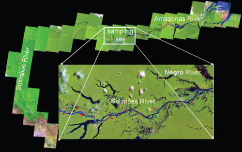
Figure 1. Study area within the Solimoes-Amazonas floodplain. Samples were collected from lake and river channels (red dots) (Novo et al., 2004).
Data Citation:
Cite this data set as follows:
Novo E.M.L.M., W. Pereira Filho and J.M. Melack. 2013. LBA-ECO LC-07 Reflectance Spectra and Water Quality of Amazon Basin Floodplain Lakes. Data set. Available on-line [http://daac.ornl.gov] from Oak Ridge National Laboratory Distributed Active Archive Center, Oak Ridge, Tennessee, USA. http://dx.doi.org/10.3334/ORNLDAAC/1144
Implementation of the LBA Data and Publication Policy by Data Users:
The LBA Data and Publication Policy [http://daac.ornl.gov/LBA/lba_data_policy.html] is in effect for a period of five (5) years from the date of archiving and should be followed by data users who have obtained LBA data sets from the ORNL DAAC. Users who download LBA data in the five years after data have been archived must contact the investigators who collected the data, per provisions 6 and 7 in the Policy.
This data set was archived in February of 2013. Users who download the data between February 2013 and January 2018 must comply with the LBA Data and Publication Policy.
Data users should use the Investigator contact information in this document to communicate with the data provider. Alternatively, the LBA website [http://lba.inpa.gov.br/lba/] in Brazil will have current contact information.
Table of Contents:
- 1 Data Set Overview
- 2 Data Characteristics
- 3 Applications and Derivation
- 4 Quality Assessment
- 5 Acquisition Materials and Methods
- 6 Data Access
- 7 References
1. Data Set Overview:
Project: LBA (Large-Scale Biosphere-Atmosphere Experiment in the Amazon)
Activity: LBA-ECO
LBA Science Component: Land Use and Land Cover
Team ID: LC-07 (Melack / Novo / Forsberg)
The investigators were Forsberg, Bruce R; Melack, John M.; Novo, Evlyn; Affonso, Adriana Gomes; Albuquerque, Paulo C Gurgel; Alcantara, Enner Herenio; Alsdorf, Douglas; Arruda, Warey de Costa ; Barbosa, Claudio ; Belger, Lauren ; Carvalho, Joao Carlos; Castellari, Sueli Pissarra; Correa, Denival Silva; Correia, Antonio; Costa, Maycira; da Costa Freitas, Corina ; Dutra, Luciano Vieira; Elmiro, Marcos Timbo; Filho, Waterloo Pereira; Franca, Andreia Maria Silva; Freitas, Ramon Morais ; Frickmann, Fernando Cruz; Gama, Fabio Furlan; Gastil-Buhl, Mary ; Goncalves, Fabio Guimaraes; Hess, Laura Lorraine; Jardim-Lima, Dayson Jose; Kemenes, Alexandre ; Kilham, Nina ; Kramer, Marc Gerald; Lima, Ivan Bergier Tavares de; Londe, Luciana de Resende; Marshall, Bruce Gavin; Mertes, Leal; Mura, Jose Claudio; Rudorff, Conrado de Moraes; Sant'Anna, Sidnei J.S.; Santos, Claudia Cristina dos; Santos, Joao Roberto dos; Shimabukuro, Yosio Edemir; Silva, Claudio Roberto; Silva, Thiago Sanna Freire; Titoneli, Fernanda and Vasconcelos, Cintia Honorio. You may contact Novo, Evlyn (evlyn@ltid.inpe.br).
LBA Data Set Inventory ID: LC07_Spectroradiometry
This data set includes bidirectional reflectance (BDR) and water quality data of floodplain lakes of the Solimoes and Negro Rivers in the central Amazon basin, Amazonas, Brazil. Samples and measurements were collected during July 2000. Bidirectional reflectance spectra, at 3 nm intervals from 400 to 900 nm, were recorded concurrently with in situ measurements of water temperature and Secchi depth, and collection of samples for analysis of optically active components including total suspended solids, chlorophyll, and dissolved organic carbon (DOC).
The lakes sampled were in the low lying varzea of the Solimoes River (varzea is the local name for floodplain formed by the overflow of white water rivers) and igapo (igapo is the local name for floodplain formed by the overflow of black water rivers) of the Negro River.
Related Data Sets
- LBA-ECO LC-07 Water Quality, CO2, Chlorophyll, Lago Curuai, Para, Brazil: 2003-2004 (Lake water quality and chlorophyll data from Lago Curuai, Para, Brazil)
- LBA-ECO LC-07 Amazon Floodplain Lake Chlorophyll from MODIS, Para, Brazil: 2002-2003 (Chloropyll concentration study of the Amazon River floodplain region)
2. Data Characteristics:
Data are presented in two ASCII comma separated files:
File #1:Water_quality_data_2000.csv
File #2: Radiometry_BRF
File #1: Water_quality_data_2000.csv
| Column | Heading | Units/format | Description |
|---|---|---|---|
| 1 | Lake_ID | Lake identification by name or number | |
| 2 | Date | YYYYMMDD | Sampling date |
| 3 | Time | HH:MM | Time of sample collection in local time |
| 4 | Latitude | decimal degrees | Sample site geographic coordinates: latitude in decimal degrees |
| 5 | Longitude | decimal degrees | Sample site geographic coordinates: longitude in decimal degrees |
| 6 | Sample_ID | Sample identification for project | |
| 7 | Secchi depth | m | Secchi depth reported in meters (m) |
| 8 | T_water | degrees C | Temperature of the water in degrees centigrade |
| 9 | TSS | mg/L | Concentration of total suspended solids reported in milligrams per liter (mg/L) |
| 10 | Chl | mg/m3 | Chlorophyll concentration in milligrams per meter cubed (mg/m3) |
| 11 | DOC | mg/L | Dissolved organic carbon concentration reported in milligrams per liter (mg/L) |
| missing data are represented by -9999 | |||
Example data records:
|
Lake_ID,Date,Time,Latitude,Longitude,Sample_ID,Secchi depth ,T_water,TSS,Chl,DOC 12,20000707,10:30,-3.81806,-62.34778,EVE-1,0.5,27.9,10.40,0.92,4.294 12,20000707,10:30,-3.81806,-62.34778,EVE-1,0.5,27.9,10.40,0.92,4.294 12,20000707,11:12,-3.82,-62.35333,EVE-3,0.38,29.2,25.42,1.379,4.476 ... 11,20000715,12:50,-3.88917,-63.875,EVE-22,1.2,27.4,16.84,5.977,5.318 11,20000715,12:58,-3.88556,-63.87639,EVE-23,1.15,27.2,17.17,5.977,3.774 11,20000715,13:08,-3.85472,-63.87639,EVE-24,0.5,27.6,17.4,4.598,3.41 ... Negro,20000802,10:43,-3.01306,-60.56639,EVE-66,1.45,30.9,17.17,0.92,10.1 Negro,20000802,10:58,-2.99528,-60.54778,EVE-67,1.5,32,9.23,0.92,10.5 Negro,20000802,1:21,-2.95833,-60.52639,EVE-68,1.5,31.6,6.39,1.839,8.934 |
File #2: File name: Radiometry_BRF.csv
| Column | Heading | Units/format | Description |
|---|---|---|---|
| 1 | Lake_ID | Lake identification by name or number | |
| 2 | Date | YYYYMMDD | Sampling date |
| 3 | Time | HH:MM | Sampling time in local time |
| 4 | Latitude | decimal degrees | Latitude of sampling location in decimal degrees |
| 5 | Longitude | decimal degrees | Longitude of sampling location in decimal degrees |
| 6 | Sample_ID | Sample identification for project | |
| 7 through 178 | wavelength in nanometers | Bidirectional reflectance factor for individual wavelengths identified in the column header | |
| missing data are represented by -9999 | |||
Example data records (examples of data values for the first 13 columns only) :
|
Lake_ID,Date,Time,Latitude,Longitude,Sample_ID,399.5,402.1,404.7,407.3,409.9,412.5,415.1,.... 12,20000707,10:30,-3.81806,-62.34778,am01,0.023397,0.023117,0.023211,0.023837,0.02387,0.023666,... 12,20000707,10:55,-3.81861,-62.35222,m02,0.019931,0.019389,0.019987,0.019864,0.019807,0.019954,0.020172,... ... 5,20000718,10:25,-3.90278,-63.42806,am37,0.013845,0.014092,0.014065,0.013975,0.013573,0.013477,0.013064,... 5,20000718,10:50,-3.8725,-63.44583,am38,0.028476,0.027977,0.028501,0.02823,0.028627,0.028799,0.028807,0.028924,... ... Negro,20000802,10:58,-2.99528,-60.54778,am67,0.010632,0.010665,0.010577,0.010429,0.01032,0.010095,0.009933,0.00989,... Negro,20000802,1:21,-2.95833,-60.52639,am68,0.011364,0.011127,0.011259,0.011283,0.011062,0.010989,0.010735,0.010587,0,... |
Site boundaries: (All latitude and longitude given in decimal degrees)
| Site (Region) | Westernmost Longitude | Easternmost Longitude | Northernmost Latitude | Southernmost Latitude | Geodetic Datum |
|---|---|---|---|---|---|
|
Amazon River west of Manaus (Amazonas (Manaus)) |
-63.90139 | -60.5264 | -2.95833 | -3.98111 | World Geodetic System, 1984 (WGS-84) |
Time period:
- The data set covers the period 2000/07/07 to 2000/08/02
- Temporal Resolution: all data were collected during one month long expedition
Platform/Sensor/Parameters measured include:
- LABORATORY / SPECTROPHOTOMETER / CHLOROPHYLL
- FIELD INVESTIGATION / SECCHI DISKS / TURBIDITY
- FIELD INVESTIGATION / SPECTRORADIOMETER / REFLECTANCE
- FIELD INVESTIGATION / TEMPERATURE PROBE / WATER TEMPERATURE
3. Data Application and Derivation:
These data could be used to determine if a predictive relationship between reflectance factors and chlorophyll concentrations exists for waters with high concentrations of total suspended solids or high concentrations of DOC.
4. Quality Assessment:
Water chemistry: Accuracy for chlorophyll-a lab analysis was 0.1 mg/m3. Accuracy for determination of total suspended solids and inorganic suspended solids was 0.005 mg/L. Organic suspended solids concentration was calculated as the difference between total suspended solids and inorganic suspended solids. Field and lab manipulations may change dissolved inorganic carbon (DIC) concentration of water samples slightly.
Specifications of parameters were measured with a routinely calibrated Horiba U-10 water quality meter.
Temperature: Thermister, resolution: 0.1 degree C, repeatability: plus or minus 0.3 degrees C, temperature compensation: N/A
Radiometric and wavelength calibration are described at url: http://snr.unl.edu/agmet/instrument-se590-main.asp
In addition to the nominal accuracy constraints of Spectron SE-590 and the calibration of the barium sulphate (BaSO4) plate, variable field conditions affect water reflectance measurements in ways that are difficult to determine. Despite the procedures described in the methods section, which were adopted to minimize interferences, unknown inaccuracies of water reflectance measurements derive mainly from the following changes of conditions at the time of sampling: roughness of water surface, cloud-cover movements, and geometry of acquisition (hand-held operation of the sensor from a boat vessel subject to movements from wave action). In general, these sources of inaccuracies produce an additive reflectance effect in the 400 to 900 nm wavelength range of interest. Rudorff et al. (2007) compared spectral reflectance of Amazon water bodies measured in the field using a Spectron SE-590 and an orbital EO-1 Hyperion image.
5. Data Acquisition Materials and Methods:
Study sites:
Our study was conducted in the central Amazon basin in the low lying varzea of the Solimoes River and the igapo of the Negro River. White water is characteristic of the Solimoes main stem and some of the floodplain lakes connected to the river. They are rich in dissolved and suspended materials drained from the Andes. The black water is the dominant water in the Negro River, and it is characterized by a low concentration of suspended and dissolved components, except for a high concentration of DOC.
Field spectroradiometry involves the study of the relationship between the spectral characteristics and their chemical and biophysical attributes. During July 2000 the Amazon floodplain aquatic systems were sampled to build a spectral library composed of 61 complete sets of in situ reflectance, water samples for chemical analyses, and in situ water measurements.
Sampling Methods
The main axis of the lake was determined and divided into equidistant segments and the sampling stations were set in places free from bottom effects.Water samples were collected at three depths with a Van Dorn bottle and combined before being used for determination of dissolved and suspended components. The following variables were determined from water samples: total suspended solids (mg per L) according to Wetzel and Likens (1991), chlorophyll concentration (mg/m3) according to Nush (1980), and DOC (mg per L) according to APHA (1998).
Temperature was obtained in situ with a Horiba U-10 water quality meter.
Secchi depth was measured with a white 20 cm Secchi disk.
Bidirectional Reflectance Factor (BRF) Measurements
At every sampling station, the BRF was measured from a boat using a portable spectrometer (Spectron SE-590). The sensor collected data in the 400 to 900 nm range at spectral intervals of 3 nm and with a 15-degree field-of-view lens attached. A polarized lens was attached to the sensor to correct for sky reflection from the water surface. A barium sulphate (BaSO4) plate of known reflectance was used as reference.
The water leaving radiance (Lw) was measured keeping the sun-sensor azimuth at 90 degrees and aiming at the water surface at a 45-degrees zenith angle to reduce sky radiance and the surface reflectance (Steffen et al., 1993). The radiance of the reference panel to a laboratory reflectance standard (Lr) was measured at the same geometry. Each of the sampled spectra was the average of four readings.
6. Data Access:
This data is available through the Oak Ridge National Laboratory (ORNL) Distributed Active Archive Center (DAAC).
Data Archive Center:
Contact for Data Center Access Information:
E-mail: uso@daac.ornl.gov
Telephone: +1 (865) 241-3952
References
APHA, 1998, Standard Methods for the Examination of Water and Wastewater, 20 edn (Washington, DC: American Public Health Association).
Novo E.M.L.M., W. Pereira Filho and J.M. Melack. 2004. Assessing the utility of spectral band operators to reduce the influence of total suspended solids on the relationship between chlorophyll concentration and the bidirectional reflectance factor in Amazon waters. Int. J. Remote Sensing, 25,(22), 5105-5116. doi:10.1080/01431160410001709048
Nush, E.A., 1980, Comparison of different methods for chlorophyll and phaeopigment determination. Archiv fur Hydrobiologie, 14, 14-39.
Rudorff, C.M., Novo, E.M.L.M., Galvao, L.S., and Pereira Filho, W. 2007. Analise derivativa de dados hiperespectrais medidos em nivel de campo e orbital para caracterizar a composicao de aguas opticamente complexas na Amazonia. Acta Amazonica, 37(2), 269-280. doi:10.1590/S0044-59672007000200014
Steffen, C., Costa, M.P.F., and Gama, F.F., 1993, Spectral reflectance of Tucuru reservoir waters in the Brazilian Amazon. Proceedings of SPIE, 1937, 103-111.
Wetzel, R.G., and Likens, G.E., 1991, Limnological Analyses (New York: Springer- Verlag).