Get Data
Summary:
This data set includes high-resolution geocoded mosaics derived from the Validation Overflight for Amazon Mosaics (VOAM) aerial video surveys as part of the Large-Scale Biosphere-Atmosphere (LBA) Experiment in the Amazon. The VOAM flights were carried out in the wet-season (June) 1999 in the Brazilian Amazon to provide ground verification for mapping of wetland cover in the Amazon Basin conducted by the Global Rain Forest Mapping (GRFM) Project JERS-1 (Japanese Earth Remote Sensing Satellite). Digital camcorder systems were installed in a Bandeirante survey plane operated by Brazil's National Institute for Space Research. The VOAM99 surveys circumscribed the Brazilian Amazon, documenting ground conditions at resolutions on the order of 1-m resolution for wetlands, forests, savannas, and human-impacted areas. Geocoded mosaics were generated by processing the aerial videography into GeoTIFF format, maximizing its usefulness for environmental monitoring applications. Other applications of the VOAM99 videography include acquisition of ground control points for image geolocation, forest biomass estimation, and rapid assessment of fire damage. Geocoded digital videography provides a cost-effective means of compiling a high-resolution validation data set for land cover mapping in remote, cloud-covered regions.
There are 314 geographic mosaics (*.tif) in this data set. In addition, 313 video clips (*.mp4) taken from the aircraft along with 315 thumbnail images (*.JPG) are provided in compressed (*.zip) format as a companion file.
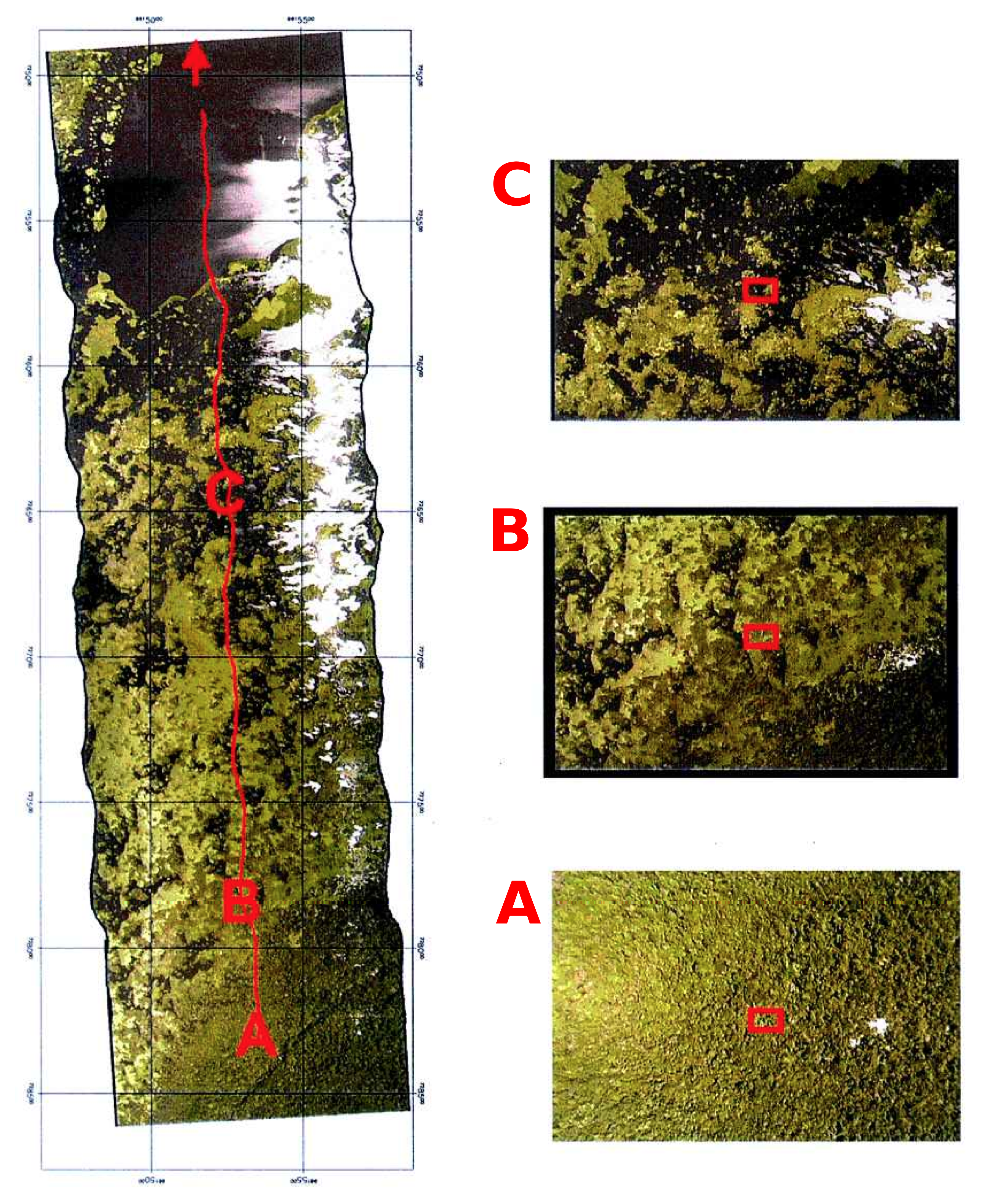
Figure 1. Example mosaicked VOAM99 strip from Amazon floodplain near Lago Cabaliana, 11 June 1999, showing aircraft flight path in red. Transition from forest on levee (A), through woodland savanna with floating macrophyte (B), to sparse woodland savanna with floating macrophyte (C), to open lake water. Adapted from Fig. 11 in Hess et al. (2002).
Data Citation:
Cite this data set as follows:
Hess, L.L., J.M. Melack, E.M.L.M. Novo, C.C.F. Barbosa, and M. Gastil-Buhl. 2015. LBA-ECO LC-07 Validation Overflight for Amazon Mosaics, Raster, 1999. Data set. Available on-line [http://daac.ornl.gov] from Oak Ridge National Laboratory Distributed Active Archive Center, Oak Ridge, Tennessee, USA. http://dx.doi.org/10.3334/ORNLDAAC/1274
Implementation of the LBA Data and Publication Policy by Data Users:
The LBA Data and Publication Policy [http://daac.ornl.gov/LBA/lba_data_policy.html] is in effect for a period of five (5) years from the date of archiving and should be followed by data users who have obtained LBA data sets from the ORNL DAAC. Users who download LBA data in the five years after data have been archived must contact the investigators who collected the data, per provisions 6 and 7 in the Policy.
This data set was archived in March 2015. Users who download the data between March 2015 and February 2020 must comply with the LBA Data and Publication Policy.
Data users should use the Investigator contact information in this document to communicate with the data provider. Alternatively, the LBA Web Site [http://lba.inpa.gov.br/lba/] in Brazil will have current contact information.
Data users should use the Data Set Citation and other applicable references provided in this document to acknowledge use of the data.
Table of Contents:
- 1 Data Set Overview
- 2 Data Description
- 3 Applications and Derivation
- 4 Quality Assessment
- 5 Acquisition Materials and Methods
- 6 Data Access
- 7 References
Project: LBA (Large-Scale Biosphere-Atmosphere Experiment in the Amazon)
Activity: LBA-ECO
LBA Science Component: Land Use and Land Cover
Team ID: LC-07 (Melack / Novo / Forsberg)
The investigators were Melack, John M.; Novo, Evlyn Marcia Leao de Moraes; Hess, Laura; Mertes, Leal, (deceased); Slaymaker, Dana Munro; Gastil-Buhl, Mary; Valeriano, Dalton De Morisson; Krug, Thelma; Hayward, C; Holt, J.; Steffen, C. and Holmes, C. You may contact Gastil-Buhl, Mary (mary@icess.ucsb.edu) and Affonso, Adriana (affonso@ltid.inpe.br).
LBA Data Set Inventory ID: LC07_Airborne_Rasters
This data set includes high-resolution geocoded mosaics derived from the Validation Overflight for Amazon Mosaics (VOAM) aerial video surveys as part of the Large-Scale Biosphere-Atmosphere (LBA) Experiment in the Amazon. The VOAM flights were carried out in the wet-season (June) 1999 in the Brazilian Amazon to provide ground verification for mapping of wetland cover in the Amazon Basin conducted by the Global Rain Forest Mapping (GRFM) Project JERS-1 (Japanese Earth Remote Sensing Satellite). Digital camcorder systems were installed in a Bandeirante survey plane operated by Brazil's National Institute for Space Research. The VOAM99 surveys circumscribed the Brazilian Amazon, documenting ground conditions at resolutions on the order of 1-m resolution for wetlands, forests, savannas, and human-impacted areas. Geocoded mosaics were generated by processing the aerial videography into GeoTIFF format, maximizing its usefulness for environmental monitoring applications. Other applications of the VOAM99 videography include acquisition of ground control points for image geolocation, forest biomass estimation, and rapid assessment of fire damage. Geocoded digital videography provides a cost-effective means of compiling a high-resolution validation data set for land cover mapping in remote, cloud-covered regions.
Related Data Sets:
- LBA-ECO LC-07 Validation Overflight for Amazon Mosaics, Video, 1999
- LBA-ECO LC-07 Monthly Mean Flooded Wetlands Habitat, Central Amazon Basin: 1979-1996
- LBA-ECO LC-07 JERS-1 SAR Wetlands Masks and Land Cover, Amazon Basin: 1995-1996
2. Data Characteristics:
The data consist of 314 geographic mosaics (*.tif). The mosaics were derived from wide-angle digital videos.
GeoTIFF Files:
The files use standard names specifying the date (yymmdd), start time, and end time. Note that some start and end times include eight digits, representing fractions of a second (hh:mm:ss.ss). Dates and times are given in UTC time.
File Naming convention:
Date_StartTime_EndTime.tif.
Example File names:
19990606_193633_193648.tif
19990606_19290227_19291326.tif
19990606_19314725_19322229.tif
19990607_144930_145000.tif
Site boundaries: (All latitude and longitude given in decimal degrees)
| Site (Region) | Westernmost Longitude | Easternmost Longitude | Northernmost Latitude | Southernmost Latitude | Datum |
|---|---|---|---|---|---|
| Amazon Basin, Brazil | -68 | -44 | 4 | -14.5042 | WGS-84 |
Spatial Resolution: Resolution of the VOAM99 raster data is approximately 1-m per pixel.
Time period: The data set covers the period 1999-06-06 to 1999-06-19.
Temporal Resolution: Multiple flights per day.
Companion Files
There are 313 video files (*.mp4) along with 315 thumbnail images (*.JPG) provided in compressed (INPE_mp4-and-JPG_clips.zip) format as a companion file. File names for the unzipped companion files follow the same convention as the GeoTIFF files. The Brazilian National Institute for Space Research (INPE) website describing this project was also captured and is provided as a companion file in compressed format (INPE_videography_website.zip).
Platform/Sensor/Parameters measured include:
- AIRCRAFT / VIDEO CAMERA / SAVANNAS
- AIRCRAFT / VIDEO CAMERA / FORESTS
- AIRCRAFT / VIDEO CAMERA / WETLANDS
3. Data Application and Derivation:
The VOAM99 data set was used to validate other LBA-ECO LC-07 data products, including: Monthly Mean Flooded Wetlands Habitat and JERS-1 SAR Wetlands Masks and Land Cover (listed under Related Datasets). This data was also used by other LBA-ECO projects, including LC-20 and LC-32. The VOAM99 data can be used to generate ground control points of known geographic location in remote, unmapped, regions. In addition, it also serves as a high-resolution historical baseline for studies of land cover change in the Amazon basin in the early 21st century (see Roberts et al 2002).
4. Quality Assessment:
Geolocation accuracy and altitude measurement accuracy are discussed in Hess et al. (2002) sections 4.3 and 4.4. The absolute geolocation accuracy of VOAM99 data is affected by errors from several sources, including: aircraft GPS location, and frame center location. For the real-time, differentially corrected GPS signal received once per second during the VOAM99 survey, expected probabilities of horizontal error are 67-73% that location error will be less than 0.5 m, 95-97% that it will be less than 1.0 m, and 99% that it will be less than 1.5 m.
5. Data Acquisition Materials and Methods:
The VOAM99 survey was conducted in June 1999 over the Legal Brazilian Amazon by Brazil’s National Institute for Space Research (INPE) and University of California, Santa Barbara. The flight lines were designed to provide coverage of intensive study sites for the LBA-ECO projects including: human-impacted areas (secondary forests, selectively logged forests, and pastures) and major floodplains of whitewater rivers including the central Solimões, Amazon, lower Purus, and lower Japurá and blackwater rivers including the lower Negro (including Anavilhanas archipelago), lower Jaú, the Balbina Reservoir, interfluvial blackwater wetlands in the Jaú basin, and the Tefé, and Mamirauá blocked-valley lakes.
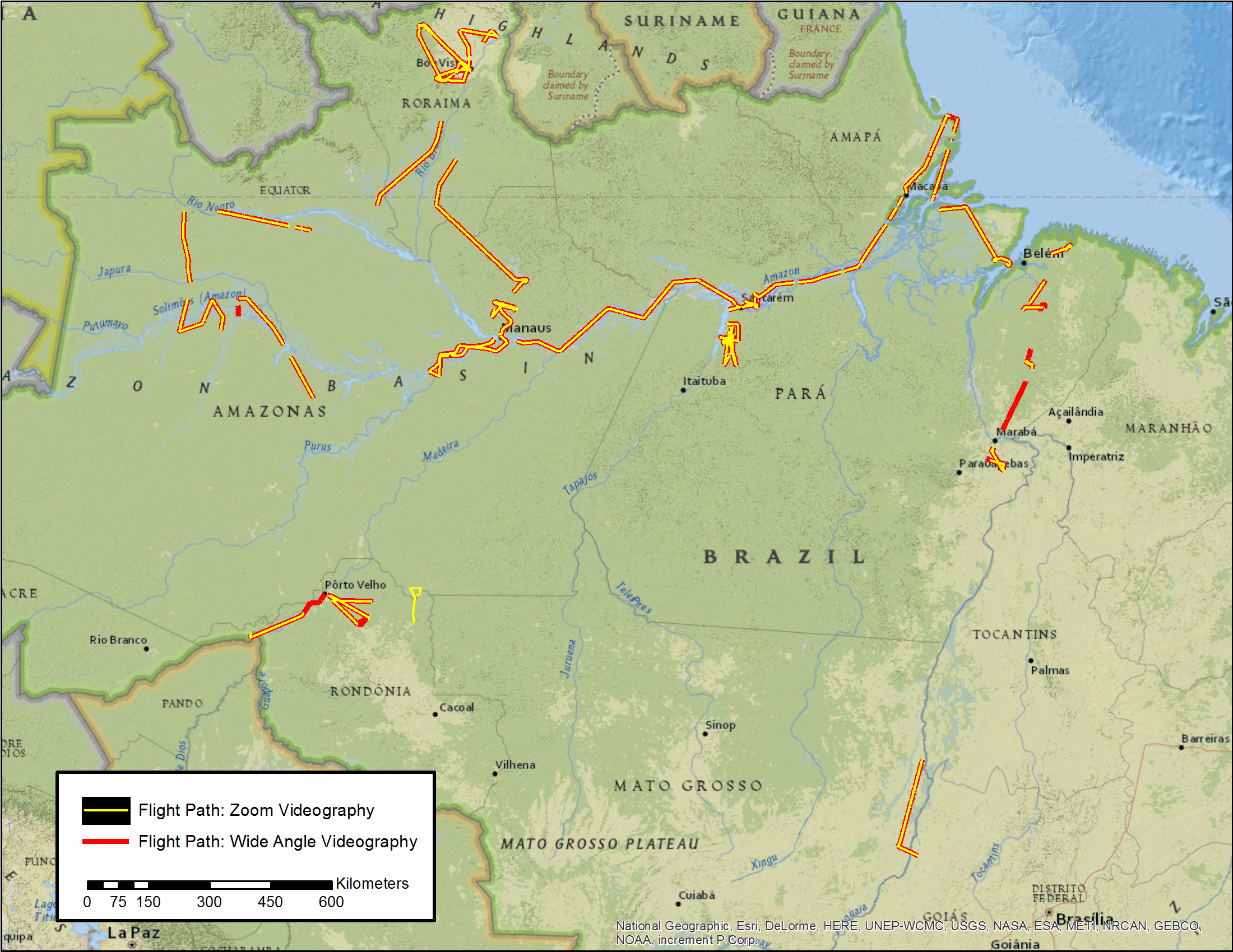
Figure 2. Overview of flight paths from the June 1999 VOAM aerial video surveys.
Aerial surveys were conducted in Brazil’s National Institute for Space Research (INPE) Bandeirante aerial survey plane, which had a camera mount custom-built in which both cameras were vertically-oriented and operated in tandem (Fig. 3)
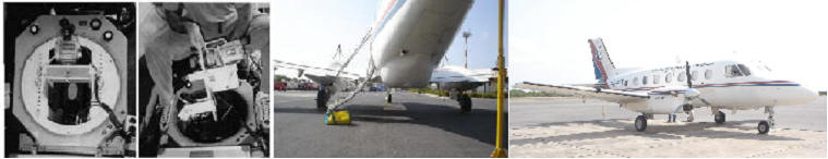
Figure 3. Digital video acquisition system for the VOAM99 survey.
The 1999 survey was conducted using a video acquisition system developed by the departments of Natural Resource Conservation and Computer Science of the University of Massachusetts (UMass) Amherst. The system included two vertically oriented digital camcorders (one in wide-angle mode and one in zoom mode), a laser range finder (904 nm wavelength) which measured aircraft height above ground or canopy, an Attitude and Heading Reference System (AHRS) which measured aircraft tip and tilt, a system GPS which received a real-time, differentially corrected GPS signal from the Omnistar commercial GPS satellite network and a Horita GPS3 Timecode Generator which converted the GPS signal to SMPTE format and encoded on the audio tracks of the digital videotapes. GPS information encoded on the video audio track was extracted by mosaicking software that automatically generated geocoded digital mosaics from the wide-angle video clips.
Flying height for the VOAM99 survey ranged from 100 to 900-m, with a median of 350 m. For segments where laser data was required, flying height was selected to maximize swath width while remaining within the range of the laser instrument and below the cloud ceiling. At the median flying height, swath width of the wide-angle video was about 550 m, with pixel dimensions of about 0.75 m. Resolution of the VOAM99 mosaic data was in general equivalent to pixel dimension, with the exception of occasional loss of focus over smooth water surfaces.
For a detailed description of Materials and Methods used see Hess et al. (2002) or or the INPE VOAM99 website (INPE_videography_website.zip).
6. Data Access:
These data are available through the Oak Ridge National Laboratory (ORNL) Distributed Active Archive Center (DAAC).
Data Archive Center:
Contact for Data Center Access Information:
E-mail: uso@daac.ornl.gov
Telephone: +1 (865) 241-3952
7. References:
Hess, L.L., E.M.L.M. Novo, D.M. Slaymaker, J. Holt, C. Steffen, D.M. Valeriano, L.A.K. Mertes, T. Krug, J.M. Melack, M. Gastil, C. Holmes, and C. Hayward. 2002. Geocoded digital videography for validation of land cover mapping in the Amazon basin. International Journal of Remote Sensing 23:1527-1555. DOI: 10.1080/01431160110092687
Roberts, D.A., I. Numata, K. Holmes, G. Batista, T. Krug, A. Monteiro, B. Powell, and O.A. Chadwick. 2002. Large area mapping of land-cover change in Rondonia using multitemporal spectral mixture analysis and decision tree classifiers. Journal of Geophysical Research 107:8073. DOI:10.1029/2001JD000374
Related publications:
Alsdorf, D.E., J.M. Melack, T. Dunne, L.A.K. Mertes, L.L. Hess, and L.C. Smith. 2000. Interferometric radar measurements of water level changes on the Amazon floodplain. Nature, 404:174-177. Available online at: http://www.obt.inpe.br/videografia/publications_arquivos/Alsdorf_et_al_2000.pdf DOI:10.1038/35004560
Hess L.L., J.M. Melack, E.M.L.M. Novo, C.C.F. Barbosa, and M. Gastil. 2003. Dual-season mapping of wetland inundation and vegetation for the central Amazon basin. Remote Sensing of Environment 87:404-428. http://dx.doi.org/10.1016/j.rse.2003.04.001 DOI: 10.1016/j.rse.2003.04.001
Shimabukuro, Y.E., E.M.L.M. Novo, L.K. Mertes. 2002. Amazon River mainstem floodplain mosaic. International Journal of Remote Sensing, 23:57-69. Available online at: http://www.obt.inpe.br/videografia/publications_arquivos/Shimabukuro_et_al_2002.pdf DOI: 0.1080/01431160010029165