Get Data
Summary:
This data set reports continuous high-resolution frequency-domain reflectometry measurements of soil moisture to 10 m depth and precipitation data near each of the two towers located at the km 83 tower site (logged forest site) in the Tapajos National Forest in the state of Para, Brazil. Measurements were made during 2002 and 2003. Soil moisture and precipitation data are provided in two comma-delimited ASCII files.
The first tower was installed in an intact forest area at this site in June 2000 (the 'intact' tower) and instrumented for eddy flux and micrometeorological measurements and operated 15 months prior to any logging in the area (Goulden et al., 2004; Miller et al., 2004; Rocha et al., 2004). In September 2001, the area adjacent to the tower was selectively logged (Bruno et al., 2006).
The second tower (the ‘gap’ tower) was installed and operating in June 2002, 400 m east of the intact tower. The gap tower was installed in the middle of a 50 m x 50 m log landing.
Soil moisture measurements were made in 10 m deep vertical pits (1 x 1 m2) approximately 20 m from the micrometeorological tower sites in undisturbed forest patches. Reflectometers were inserted horizontally into shaft walls at 0.15, 0.30, 0.60, 1, 2, 3, 4, 6, 8, and 10 meters beneath the surface. These data were used to determine how soil moisture varies on diel, seasonal and multi-year timescales and to better understand the quantitative and mechanistic relationships between soil moisture and forest evapotranspiration.
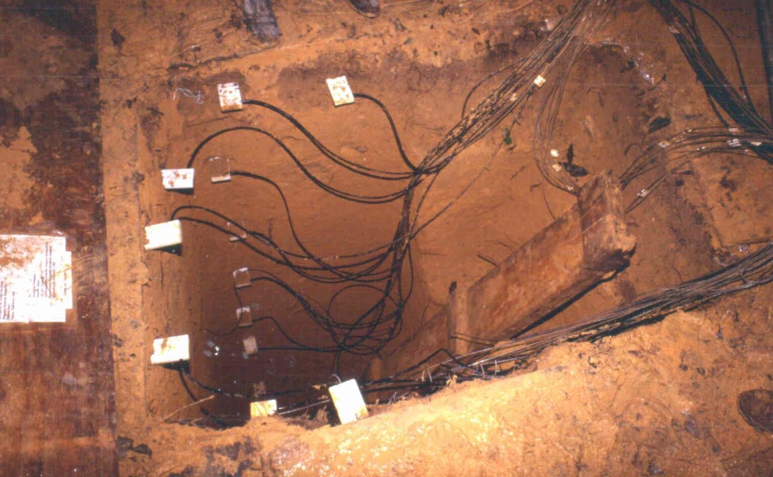
Figure 1. Soil moisture measurements were made in 10 m deep vertical pit (1 x 1 m2) approximately 20 m from the micrometeorological tower sites in undisturbed forest patches. Reflectometers were inserted horizontally into shaft walls at 0.15, 0.30, 0.60, 1, 2, 3, 4, 6, 8, and 10 meters beneath the surface.
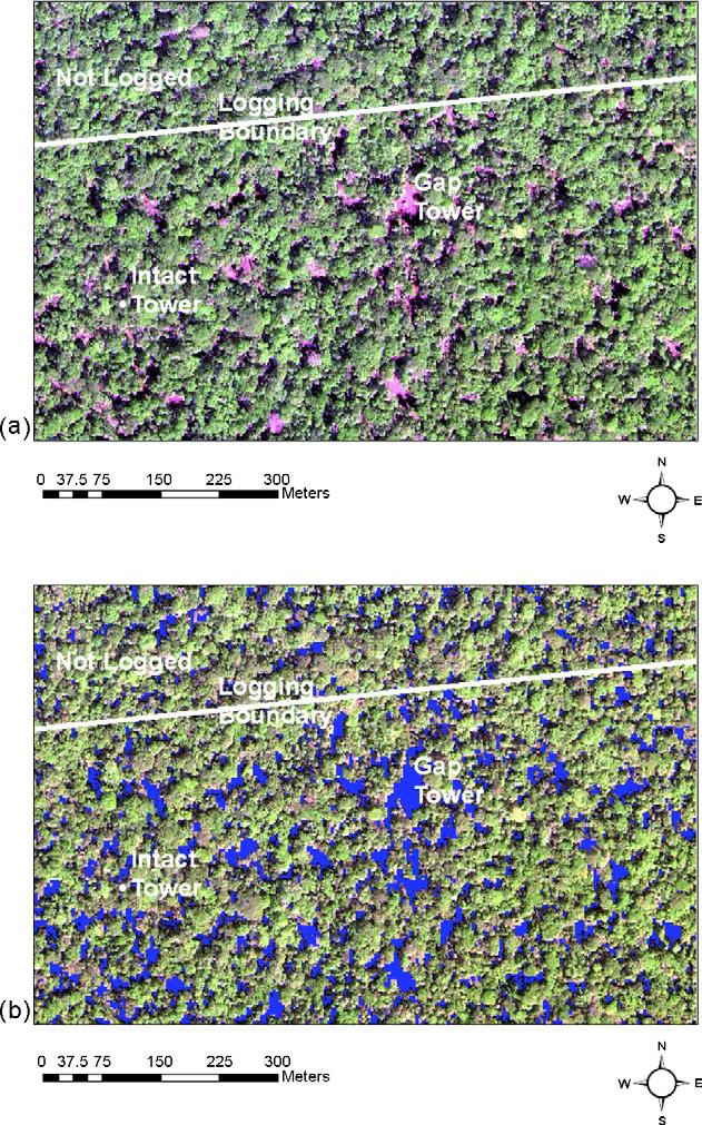
Figure 2. (a) False color IKONOS image for November 14, 2001 at 14:15 Universal Time showing the locations of the intact forest tower, the logging gap tower, and the approximate boundary between selectively logged areas to the south and unlogged forest to the north. Red corresponds to the IKONOS red band; Green is the near IR band; Blue is the blue band. Vegetation shows up as green due to the reflectance of foliage in the near IR; bare soil, litter and slash show up as pink, shadows are dark. The sun was to the southeast during the image (Sun Azimuth: 133.48, Sun Elevation: 67.28), and the northwestern sides of gaps are mostly pink (illuminated soil) and the southeastern sides of gaps are mostly dark shadow); (b) Same as (a), except gaps, which were identified as areas with a Normalized Difference Vegetation Index (NDVI) of less than 0.4 are shown as blue. From Miller et al., 2007.
Data Citation:
Cite this data set as follows:
Goulden, M.L. S.D. Miller and H.R. da Rocha. 2010. LBA-ECO CD-04 Soil Moisture Data, km 83 Tower Site, Tapajos National Forest, Brazil. Data set. Available on-line [http://daac.ornl.gov] from Oak Ridge National Laboratory Distributed Active Archive Center, Oak Ridge, Tennessee, U.S.A. doi:10.3334/ORNLDAAC/979
Implementation of the LBA Data and Publication Policy by Data Users:
The LBA Data and Publication Policy [http://daac.ornl.gov/LBA/lba_data_policy.html] is in effect for a period of five (5) years from the date of archiving and should be followed by data users who have obtained LBA data sets from the ORNL DAAC. Users who download LBA data in the five years after data have been archived must contact the investigators who collected the data, per provisions 6 and 7 in the Policy.
This data set was archived in July of 2010. Users who download the data between July 2010 and June 2015 must comply with the LBA Data and Publication Policy.
Data users should use the Investigator contact information in this document to communicate with the data provider. Alternatively, the LBA Web Site [http://lbaeco-archive.ornl.gov/] in Brazil will have current contact information.
Data users should use the Data Set Citation and other applicable references provided in this document to acknowledge use of the data.
Table of Contents:
- 1 Data Set Overview
- 2 Data Characteristics
- 3 Applications and Derivation
- 4 Quality Assessment
- 5 Acquisition Materials and Methods
- 6 Data Access
- 7 References
1. Data Set Overview:
Project: LBA (Large-Scale Biosphere-Atmosphere Experiment in the Amazon)
Activity: LBA-ECO
LBA Science Component: Carbon Dynamics
Team ID:CD-04 (Goulden / Rocha)
The investigators were Goulden, Prof. Michael L.; Miller, Dr. Scott Dennis; Rocha, Prof. Humberto Ribeiro da; Freitas, Helber Custodio de and Rogerio Bruno . You may contact Miller, Dr. Scott D. (smiller@albany.edu) ; Rogerio Bruno (rogerio@model.iag.usp.br) and Humberto da Rocha (humberto@model.iag.usp.br)
LBA Data Set Inventory ID: CD04_Soil_Moisture_Km83
This data set reports continuous
high-resolution frequency-domain reflectometry measurements of
soil moisture to 10 m depth and precipitation data near each of the two towers located at the
km 83
tower site (logged forest site) in the Tapajos National Forest in the state of
Para, Brazil. Measurements were made during 2002 and 2003. Soil
moisture and precipitation data are provided in two
comma-delimited
ASCII files. We used these data to determine how soil moisture
varies on diel, seasonal, and multi-year timescales and to better understand the
quantitative and mechanistic relationships between soil moisture and
forest evapotranspiration.
Related Data Sets
- LBA-ECO CD-04 CO2 Profiles, km 83 Tower Site, Tapajos National Forest (Carbon dioxide profile measurements from a nearby 65 m tower at the intact forest site with an overlapping time period)
- LBA-ECO CD-04 Meteorological and Flux Data, km 83 Tower Site, Tapajos National Forest (Carbon dioxide flux data from the nearby 65 m tower at the intact forest site with an overlapping time period)
2. Data Characteristics:
Data are provided in two comma-delimited ASCII files.
CD04_TNF_KM83_Soil_Moisture.csv contains soil moisture data (March 2002 - December 2003) and rainfall (January 2002 through December 2003) measurements from the km 83 site intact tower location.
CD04_TNF_KM83_Gap_Soil_Moisture.csv contains soil moisture data and rainfall measurements (February 2002 - December 2003) from the km 83 site gap tower location.
File name: CD04_TNF_KM83_Soil_Moisture.csv
| Column number | Column heading | Units/format | Description |
|---|---|---|---|
| 1 | Date | yyyy/mm/dd | Sample date |
| 2 | Hour | HH:MM | Time at the start of the sampling period 24 hour clock: time in local time which is GMT -4 hours |
| 3 | Exp_Day | Decimal day since Jan 1 2000 ( 1= midnight January 1 2000) | |
| 4 | Rainfall | mm | Total rainfall in millimeters (mm) recorded over the 30-minute sampling period |
| 5 | VWC_15cm | m3/m3 | Volumetric water content at 15 cm depth |
| 6 | VWC_30cm | m3/m3 | Volumetric water content at 30 cm depth |
| 7 | VWC_60cm | m3/m3 | Volumetric water content at 60 cm depth |
| 8 | VWC_100cm | m3/m3 | Volumetric water content at 100 cm depth |
| 9 | VWC_200cm | m3/m3 | Volumetric water content at 200 cm depth |
| 10 | VWC_300cm | m3/m3 | Volumetric water content at 300 cm depth |
| 11 | VWC_400cm | m3/m3 | Volumetric water content at 400 cm depth |
| 12 | VWC_600cm | m3/m3 | Volumetric water content at 600 cm depth |
| 13 | VWC_800cm | m3/m3 | Volumetric water content at 800 cm depth |
| 14 | VWC_1000cm | m3/m3 | Volumetric water content at 1000 cm depth |
| missing data are represented by -999 | |||
Example data records:
Date,Hour,Exp_Day,Rainfall,VWC_15cm,VWC_30cm,VWC_60cm,VWC_100cm,VWC_200cm,VWC_300cm, VWC_400cm,VWC_600cm,VWC_800cm,VWC_1000cm, 2001/12/31, 00:00,731,0.0000,-999,-999,-999,-999,-999,-999,-999,-999,-999,-999, 2001/12/31, 00:30,731.020813,-999,-999,-999,-999,-999,-999,-999,-999,-999,-999,-999, ... 2003/05/25, 03:00,1241.125,0.0000,0.5039,0.4986,0.4895,0.4890,0.4882,0.4789,0.4867,0.5118,0.5070,0.5301, 2003/05/25, 03:30,1241.145874,0.0000,0.5040,0.4987,0.4894,0.4890,0.4881,0.4789,0.4867,0.5118,0.5071,0.5300, 2003/05/25, 04:00,1241.166626,0.0000,0.5040,0.4986,0.4894,0.4890,0.4881,0.4789,0.4867,0.5118,0.5071,0.5299, ... 2003/12/17, 23:00,1447.958374,0.0000,0.4855,0.4771,0.4609,0.4548,0.4604,0.4666,0.4572,0.4692,-999,0.5014, 2003/12/17, 23:30,1447.979126,0.0000,0.4855,0.4771,0.4608,0.4549,0.4604,0.4667,0.4567,0.4692,-999,0.5015, |
CD04_TNF_KM83_Gap_Soil_Moisture.csv
| Column number | Column heading | Units/format | Description |
|---|---|---|---|
| 1 | Date | yyyy/mm/dd | Sample date |
| 2 | Hour | HH:MM | Time at the start of the sampling period 24 hour clock: time in local time which is GMT -4 hours |
| 3 | Exp_Day | Decimal day since Jan 1 2000 ( 1= midnight January 1 2000) | |
| 4 | Rainfall | mm | Total rainfall in millimeters (mm) recorded over the 60-minute sampling period |
| 5 | VWC_15cm | m3/m3 | Volumetric water content at 15 cm depth |
| 6 | VWC_30cm | m3/m3 | Volumetric water content at 30 cm depth |
| 7 | VWC_60cm | m3/m3 | Volumetric water content at 60 cm depth |
| 8 | VWC_100cm | m3/m3 | Volumetric water content at 100 cm depth |
| 9 | VWC_200cm | m3/m3 | Volumetric water content at 200 cm depth |
| 10 | VWC_300cm | m3/m3 | Volumetric water content at 300 cm depth |
| 11 | VWC_400cm | m3/m3 | Volumetric water content at 400 cm depth |
| 12 | VWC_600cm | m3/m3 | Volumetric water content at 600 cm depth |
| 13 | VWC_800cm | m3/m3 | Volumetric water content at 800 cm depth |
| 14 | VWC_1000cm | m3/m3 | Volumetric water content at 1000 cm depth |
| missing data are represented by -999 | |||
Example data records:
| Date,Hour,Exp_Day,Rainfall,VWC_15cm,VWC_30cm,VWC_60cm,VWC_100cm,VWC_200cm,VWC_300cm, VWC_400cm,VWC_600cm,VWC_800cm,VWC_1000cm, 2002/02/28,17:00,790.708374,0.0000,0.5613,0.5376,0.5006,0.5340,0.5436,0.4864,0.5276,0.5595,0.5672,0.5559, 2002/02/28,18:00,790.75,0.0000,0.5606,0.5369,0.5004,0.5345,0.5426,0.4856,0.5259,0.5602,0.5674,0.5558, ... 2002/11/12,10:00,1047.416626,0.0000,0.5500,0.5406,0.5029,0.5268,0.5406,0.4895,0.4833,0.5583,0.5699,0.5636, 2002/11/12,11:00,1047.458252,0.0000,0.5499,0.5404,0.5027,0.5266,0.5406,0.4894,0.4833,0.5583,0.5699,0.5635, 2002/11/12,12:00,1047.5,0.0000,0.5497,0.5403,0.5025,0.5265,0.5405,0.4894,0.4834,0.5583,0.5699,0.5636, ... 2003/12/16,19:00,1446.791626,-999,-999,-999,-999,-999,-999,-999,-999,-999,-999,-999, 2003/12/16,20:00,1446.833252,-999,-999,-999,-999,-999,-999,-999,-999,-999,-999,-999, |
Site boundaries: (All latitude and longitude given in degrees and fractions)
| Site (Region) | Westernmost Longitude | Easternmost Longitude | Northernmost Latitude | Southernmost Latitude | Geodetic Datum |
|---|---|---|---|---|---|
| Para Western (Santarem) - km 83 Logged Forest Tower (Para Western (Santarem)) | -54.9707 | -54.9707 | -3.017 | -3.017 | World Geodetic System, 1984 (WGS-84) |
Time period:
- The data set covers the period 2001/12/31 to 2003/12/17.
- Temporal Resolution: 30-Minute and 60-Minute
Platform/Sensor/Parameters measured include:
- TOWER / RAIN GAUGE / PRECIPITATION AMOUNT
- FIELD INVESTIGATION / TDR (TIME DOMAIN REFLECTOMETRY PROBE) / SOIL MOISTURE/WATER CONTENT
3. Data Application and Derivation:
Effects of predicted climate changes in tropical regions are poorly understood. Scenarios for alterations of the Amazonian vegetation in the coming decades point to a possible shift to a new equilibrium with 'savanaisation' in some regions (Oyama and Nobre 2003), or in more extreme cases the possible collapse of forest faced with a drier climate (Cox et al. 2000). These scenarios are based on mechanistic models of ecosystem function and land-atmosphere exchange that contain many assumptions about the relationships between drought, soil water, plant uptake and plant physiology (e.g. Sellers et al. 1996). These scenarios of the future of the Amazon region can be improved by accurate measures of the forest response to drought. The data we report can be used to test, validate and calibrate models of the Amazonian land-atmosphere exchange.
4. Quality Assessment:
These data have been carefully reviewed and there are no known problems. We caution the data user that we sampled single profiles at each location and that spatial heterogeneity may confound the quantitative relationships between soil measurements and the entire forest's hydrological budget.
Site specific calibrations for the CS615-G probes were developed using 10 cm x 10 cm x 40 cm soil blocks collected at 6 cm (2 samples) and 76 cm (1 sample) depth (Bruno et al. 2006). Calibration data were collected continuously comparing the sensor signal with the soil water content determined by gravimetry throughout a drying cycle. Calibration curves were fit using a sigmoidal function that constrained the asymptotic lower (dry soil) and upper (saturation) limits. The use of a site specific calibration resulted in calculated water contents that were as much as 40 percent greater than those that would have been calculated from a generic cubic polynomial for clayey soil (Campbell Scientific 1996).
5. Data Acquisition Materials and Methods:
This study was conducted at the LBA km 83 research site (logged forest site) in the Tapajos National Forest in the state of Para (Bruno et al., 2006). The site was located on flat, upland terrain. The soil at the site was a yellow distrophic latosol (a clay Oxisol). The vegetation was dense, tropical, humid forest with a canopy height of 35-40 m.
The first tower was installed in an intact forest area at this site in June 2000 (the 'intact' tower) and instrumented for eddy flux and micrometerological measurements and operating 15 months prior to any logging in the area In September 2001 the area along the tower fetch was selectively logged with 2-3 trees per hectare removed. Soil moisture measurements were made in a soil pit approximately 20 m southeast of the micrometerological tower site in an undisturbed patch within the selectively logged area. The second tower (the ‘gap’ tower) was installed and operating in June 2002, 400 m east of the intact tower. The gap tower was installed in the middle of a 50 m x 50 m log landing. Soil moisture measurements were made in a 10 m deep vertical pits (1 x 1 m2) approximately 20 m from the micrometerological tower sites in undisturbed forest patches. Reflectometers were inserted horizontally into shaft walls at 0.15, 0.30, 0.60, 1, 2, 3, 4, 6, 8, and 10 meters beneath the surface.
Soil water content
Soil water content was estimated using transit time (Tau) measured with
water content reflectometers (CS615-G, Campbell Scientific, Logan ,
Utah USA) installed in a 10 m deep vertical pit (1 x 1 m2).
Reflectometers were inserted horizontally into shaft walls at 0.15,
0.30, 0.60, 1, 2, 3, 4, 6, 8, and 10 meters beneath the surface. Two
sensors were installed at each depth and the volumetric water content
at each depth was averaged, except at the 8 meter depth where only one
sensor was installed. The CS615-G is a bistable mutlivibrator connected
to two stainless steel rods (30 cm long, 3.2 mm diameter and 32 mm
spaced). The output signal (period tau) ranges from 0.7 to 1.6 ms and
varies with the medium dielectric constant and therefore the soil
moisture. The soil moisture data were recorded at 0.5 Hz throughout the
study. The intact tower data are reported on a 30-minute basis and the gap tower data are reported on a 60-minute basis.
Rainfall
Rainfall (mm) was
measured at 64 meters on the towers and totaled over the 30 or
60-minute sampling period (TE525 Texas Electronics, Dallas, Texas,
USA).
During the 3 year sampling period on the intact forest tower,
between January 2001 and December 2003, gaps
in rain data occurred in May 2002, November 2002, and May 2003. The
intact tower data are reported on a 30-minute basis and the gap tower
data are reported on a 60-minute basis.
6. Data Access:
This data is available through the Oak Ridge National Laboratory (ORNL) Distributed Active Archive Center (DAAC).
Data Archive Center:
Contact for Data Center Access Information:
E-mail: uso@daac.ornl.gov
Telephone: +1 (865) 241-3952
7. References:
Brun, RD 2004. Variabilidade observada da umidade do solo em Floresta Tropical e Cerrado. Master's Thesis. Institute of Astronomy, Geophysics and Atmospheric Sciences (IAG), University of Sao Paulo, Sao Paulo Brazil.
Bruno, R.D., H.R. da Rocha, H.C. de Freitas, M.L. Goulden, and S.D. Miller. 2006. Soil moisture dynamics in an eastern Amazonian tropical forest. Hydrological Processes 20(12):2477-2489. doi:10.1002/hyp.6211
da Rocha, H.R., M.L. Goulden, S.D. Miller, M.C. Menton, L.D.V.O. Pinto, H.C. de Freitas, and A.M.E.S. Figueira. 2004. Seasonality of water and heat fluxes over a tropical forest in eastern Amazonia. Ecological Applications 14(4):S22. doi:10.1890/02-6001
Campbell Scientific 1996. CS615 Water Content Reflectometer- Instruction Manual. Version 8221-07, Revised 10/1996. Campbell Scientific Inc. Utah USA.
Cox PM, Betts RA, Jones CD, Spall SA, and Totterdell IJ. 2000. Acceleration of global warming due to carbon-cycle feedbacks in a coupled climate model. Nature 408: 184-187. doi:10.1038/35041539
Oyama MD and Nobre CA. 2003. A new climate-vegetation equilibrium state for tropical South America. Geophysical Research Letters doi:10.1029/2003GL018600
Sellers PJ, Randall DA, Collatz GJ, et al. 1996. A revised land surface parameterization (SiB2) for atmospheric GCMs. Part I: Model formulation. Journal of Climate 9: 676-705. doi:10.1175/1520-0442(1996)009<0676:ARLSPF>2.0.CO;2
Related Publications
- Bruno, R.D., H.R. da Rocha, H.C. de Freitas, M.L. Goulden, and S.D. Miller. 2006. Soil moisture dynamics in an eastern Amazonian tropical forest. Hydrological Processes 20(12):2477-2489. doi:10.1002/hyp.6211
- da Rocha, H.R., M.L. Goulden, S.D. Miller, M.C. Menton, L.D.V.O. Pinto, H.C. de Freitas, and A.M.E.S. Figueira. 2004. Seasonality of water and heat fluxes over a tropical forest in eastern Amazonia. Ecological Applications 14(4):S22. doi:10.1890/02-6001