Documentation Revision Date: 2016-09-16
Data Set Version: V1
Summary
This data set includes five data files in comma-separated values (*.csv) format.
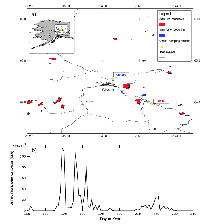
Figure 1: (a) Map of the aerosol sampling stations in Alaska, (b) daily sum of fire radiative power from MODIS active fires in 2013 Alaska (Mouteva et al 2015).
Citation
Mouteva, G.O., C.I. Czimczik, S.M. Fahrni, E.B. Wiggins, B.M. Rogers, S. Veraverbeke, X. Xu, G.M. Santos, J. Henderson, C.E. Miller, and J.T. Randerson. 2016. CARVE: Fire-Related Aerosol and Soil Elemental and Isotopic Composition, Alaska, 2013. ORNL DAAC, Oak Ridge, Tennessee, USA. http://dx.doi.org/10.3334/ORNLDAAC/1340
Table of Contents
- Data Set Overview
- Data Characteristics
- Application and Derivation
- Quality Assessment
- Data Acquisition, Materials, and Methods
- Data Access
- References
Data Set Overview
This data set provides results of aerosol sampling for black carbon, organic carbon, total carbon, and nitrogen and their isotopic composition from boreal fire emissions in Alaska in summer 2013. The delta14C end member of fire aerosol was derived and linked to soil elemental and isotopic composition. Soil and aerosol measurements were used to estimate average depth of burn in Alaska during the summer of 2013. These data were collected as part of NASA’s Carbon in Arctic Reservoirs Vulnerability Experiment (CARVE).
Project: Carbon in Arctic Reservoirs Vulnerability Experiment (CARVE)
CARVE is collecting detailed measurements of important greenhouse gases on local to regional scales in the Alaskan Arctic and demonstrating new remote sensing and improved modeling capabilities to quantify Arctic carbon fluxes and carbon cycle-climate processes. Ultimately, CARVE will provide an integrated set of data that will provide unprecedented experimental insights into Arctic carbon cycling.
Related Publication:
Mouteva, G. O., et al. (2015), Black carbon aerosol dynamics and isotopic composition in Alaska linked with boreal fire emissions and depth of burn in organic soils, Global Biogeochem. Cycles, 29, http://dx.doi.org/10.1002/2015GB005247
Related Data Sets:
Veraverbeke, S., B.M. Rogers, and J.T. Randerson. 2015. CARVE: Alaskan Fire Emissions Database (AKFED), 2001-2013. ORNL DAAC, Oak Ridge, Tennessee, USA. http://dx.doi.org/10.3334/ORNLDAAC/1282
Data Characteristics
Spatial Coverage: Interior Alaska, USA
Spatial Resolution: Point locations
Temporal Coverage: 20130627 to 20130810
Temporal Resolution: Variable
Study Area: (Latitude and longitude given in decimal degrees)
|
Site (Region) |
Westernmost Longitude |
Easternmost Longitude |
Northernmost Latitude |
Southernmost Latitude |
|
Interior Alaska, US |
-168 |
-140 |
70.5 |
61.5 |
Table 1. Data files
|
File Name |
Description |
|
aerosol_C_N_composition.csv |
Carbon and nitrogen composition and isotopic data from summer 2013 aerosol sampling |
|
fire_derived_14C_endmember.csv |
Isotopic analysis of total carbon in aerosols |
|
BC_modeled_emissions.csv |
Black carbon emissions modeled by combining the Alaska Fire Emissions Database with the coupled WRF-STILT model of Henderson et al (2015) |
|
soil_core_C_N_composition.csv |
Carbon and nitrogen composition and isotopic data from soil cores taken by Rogers et al. (2014) |
|
soil_depth_integrated_C_N_composition.csv |
Depth-integrated soil core composition and carbon loss due to fires |
Table 2. Data fields in aerosol_C_N_composition.csv. Missing data are coded as -999.
|
Field name |
Units |
Description |
|
Sampling begin date |
yyyymmdd |
Date aerosol sampling began |
|
Sampling end date |
yyyymmdd |
Date aerosol sampling ended |
|
Station |
Aerosol sampling location |
|
|
Sample description |
Description of fire conditions during sample collection |
|
|
Day of year |
Day |
Sampling period in day of year 2013 |
|
BC |
Micrograms per cubic meter of air |
Black carbon aerosols |
|
BC_14C |
Per mil |
BC radiocarbon measurement raw data |
|
BC_14C_fire |
Per mil |
BC radiocarbon measurement after background subtraction via isotope mass balance |
|
TC |
Micrograms per cubic meter of air |
Total carbon aerosol |
|
TC_14C |
Per mil |
TC radiocarbon measurement raw data |
|
TC_14C_fire |
Per mil |
TC radiocarbon measurement after background subtraction via isotope mass balance |
|
OC |
Micrograms per cubic meter of air |
Organic carbon aerosol |
|
OC_14C |
Per mil |
OC radiocarbon measurement raw data |
|
OC_14C_fire |
Per mil |
OC radiocarbon measurement after background subtraction via isotope mass balance |
|
delta13C |
Per mil |
Stable carbon isotope |
|
Nitrogen |
Micrograms per cubic meter of air |
Nitrogen content |
|
delta15N |
Per mil |
Nitrogen stable isotope raw data |
|
delta15N_fire |
Per mil |
Nitrogen stable isotope measurement after background subtraction via isotope mass balance. Background measurements are listed as ‘bkg’. |
|
Carbon:Nitrogen |
n/a |
Total carbon to nitrogen ratio raw data |
|
C:N_fire |
n/a |
Total carbon to nitrogen ratio after separately subtracting carbon background and nitrogen background and calculating new background corrected ratio. Background measurements are listed as ‘bkg’. |
Table 3. Data fields in fire_derived_14C_endmember.csv. Missing data are coded to -999.
|
Field name |
Units |
Description |
|
Method and Station |
n/a |
Method of background subtraction and sampling station. |
|
BC_14C_fire |
Per mil |
Fire-derived 14C of BC. Average of all fire samples at corresponding station and for applied method |
|
BC_fire_Stdev |
Per mil |
Standard deviation of all fire 14C BC samples at corresponding station and for applied method |
|
TC_14C_fire |
Per mil |
Fire-derived 14C of TC. Average of all fire samples at corresponding station and for applied method |
|
TC_fire_Stdev |
Per mil |
Standard deviation of all fire 14C TC samples at corresponding station and for applied method |
|
OC_14C_fire |
Per mil |
Fire-derived 14C of OC. Average of all fire samples at corresponding station and for applied method |
|
OC_fire_Stdev |
Per mil |
Standard deviation of all fire 14C OC samples at corresponding station and for applied method |
*Note: The last row in fire_derived_14C_endmember.csv contains values averaged over both stations and both methods.
Table 4. Data fields in BC_modeled_emissions.csv. Missing data are coded to -999.
|
Field name |
Units |
Description |
|
Day of Year |
Fractional day |
Fractional Julian day of 2013 at a 6-h time step |
|
BC Caribou |
Micrograms per cubic meter of air |
Modeled BC concentrations at Caribou sampling station |
|
BC Delta |
Micrograms per cubic meter of air |
Modeled BC concentrations at Delta sampling station |
Table 5. Data fields in soil_core_C_N_composition.csv. Missing data are coded to -999.
|
Field name |
Units |
Description |
|
Identifier |
n/a |
Soil core collection location identifier from Rogers et al., 2014 |
|
Core |
n/a |
Soil core description. A-F denotes different cores within each collection area from Rogers et al., 2014. |
|
Soil_Horizon |
n/a |
Soil horizon description: LD - top live layer; F - fibric; M - mesic & humic; H - mineral soil with possibly some humic |
|
Upper_depth |
cm below surface |
Upper depth of soil layer |
|
Lower_depth |
cm below surface |
Lower depth of soil layer |
|
Weight |
g |
Weight of soil horizon samples |
|
Volume |
cm3 |
Volume of soil horizon sample |
|
Bulk_Density |
g/cm3 |
Bulk density of soil horizon sample |
|
pct_C |
% |
Percent carbon content of soil horizon sample |
|
pct_N |
% |
Percent nitrogen content of soil horizon sample |
|
C/N |
n/a |
Carbon to nitrogen ratio of soil horizon sample |
|
mgC/g soil |
mg/g |
Calculated soil horizon carbon content per soil mass |
|
mgN/g soil |
mg/g |
Calculated soil horizon nitrogen content per soil mass |
|
mgC/cm3 soil |
mg/cm3 |
Calculated soil horizon carbon content per soil volume |
|
mgN/cm3 soil |
mg/cm3 |
Calculated soil horizon nitrogen content per soil volume |
|
d15N |
Per mil |
Nitrogen stable isotope content of soil horizon |
|
13C |
Per mil |
Carbon stable isotope content of soil horizon, measured via gas bench |
|
14C |
Per mil |
Radiocarbon content of soil horizon, measured by AMS |
|
14C_err |
Per mil |
Radiocarbon measurement uncertainty, measured by AMS |
Table 6. Data fields in soil_depth_integrated_C_N_composition.csv. Missing data are coded to -999.
|
Field name |
Units |
Description |
|
Depth |
cm |
Soil depth, measured from top of soil. We used 0.5 cm intervals to integrate cumulative elemental and isotopic composition at depth. For depths >29 cm, values were calculated by assuming a linear relationship within the last few layers and propagating it to depth. |
|
14C |
Per mil |
Cumulative radiocarbon content of soil integrated with depth |
|
13C |
Per mil |
Cumulative stable carbon isotopic content of soil integrated with depth |
|
15N |
Per mil |
Cumulative stable nitrogen isotopic content of soil integrated with depth |
|
C_loss |
Kg C/ m2 |
Carbon loss per m2 integrated with depth |
*Note: At the bottom of the table, average values are provided for all black spruce land cover types (average of data from cores COO2, COO5, and COO6). A weighted average contribution from black spruce and white spruce/mixed aspen land cover types is also provided for each soil horizon. The weighting was 0.7 black spruce + 0.3 white spruce.
Companion files:
One companion file: PWRF-STILT_BC_Model.pdf is provided. This file describes the integration of the AKFED and WFR-STILT models to produce black carbon estimates from Alaskan fires.
Application and Derivation
Black carbon (BC) aerosol emitted by boreal fires has the potential to accelerate losses of snow and ice in many areas of the Arctic, yet the importance of this source relative to fossil fuel BC emissions from lower latitudes remains uncertain. These measurements of fire-emitted BC and aerosol composition constrain the end-member of boreal forest fire contributions to aerosol deposition in the Arctic and may ultimately reduce uncertainties related to the impact of a changing boreal fire regime on the climate system.
Quality Assessment
Measurement uncertainty and standard deviation in the observations are reported in the data files.
Data Acquisition, Materials, and Methods
Aerosol Samples
Aerosol samples were collected at two locations in interior Alaska during the summer of 2013 (27 June to 10 August). One site was located at Caribou Poker Creek Long-Term Ecological Research Station (“Caribou”; 65.13°N, 147.45°W) and the other at Delta Junction Agricultural and Forestry Experimental Site (“Delta”; 63.97°N, 145.40°W).
High-volume total suspended particulate samplers (HIVOL-AMCLD, Thermo Environmental Instruments, Franklin, MA, USA) with PM2.5 impactor plates (TE-230-QZ, Tisch Environmental, Cleves, OH, USA) were used. Black carbon content of each PM2.5 aerosol sample was isolated from the organic carbon fraction and the 14C content was measured via accelerator mass spectrometry (AMS). Aerosol samples were also analyzed for their total carbon and nitrogen (N) content and stable isotope ratios.
Soil Cores
To help relate carbonaceous aerosol measurements to soil emissions, a set of four soil cores were collected in August of 2012 in unburned (control) areas near the Gilles Creek fire perimeter (COO2: 64.33°N, 145.88°W; COO4: 64.31°N, 145.94°W; COO5: 64.32°N, 145.89°W; COO6: 64.36°N, 145.58°W), described by Rogers et al. (2014), were analyzed. The four soil cores representing control sites of typical land cover types outside the Gilles Creek 2010 fire. The cores were separated into three soil horizons and analyzed for their total carbon and nitrogen elemental composition, stable isotopes delta13C and delta15N, and delta14C. All of the measurements represent a vertical average for each soil horizon.
Depth integration was calculated for each soil core for every 1 cm depth interval. Depth-integrated measurements of delta14C, delta13C, carbon loss per m2, and delta15N were calculated as weighted average contribution of black spruce (70%) and mixed white spruce aspen (30%) forest of all soil cores. We used a linear regression in the mesic layer to extend the estimates deeper in the soil for the purpose of comparing with the aerosol measurements.
Modeled Black Carbon
Black carbon emissions from fires were modeled by combining the Alaska Fire Emissions Database (AKFED) model [Veraverbeke et al., 2015; available online here: http://dx.doi.org/10.3334/ORNLDAAC/1282] with the coupled Weather Research and Forecasting-Stochastic Time- Inverted Lagrangian Transport (WRF-STILT) model [Henderson et al., 2015]. Carbon emissions from AKFED were converted with an emission factor of 0.5 g BC per 1 kg biomass, based on Akagi et al. [2011], and integrated with the WRF-STILT model to estimate BC concentrations from fires at the Caribou and Delta aerosol sampling stations. See companion file PWRF-STILT_BC_Model.pdf for more details.
For more information on methodology, see Mouteva et al (2015).
Data Access
These data are available through the Oak Ridge National Laboratory (ORNL) Distributed Active Archive Center (DAAC).
CARVE: Fire-Related Aerosol and Soil Elemental and Isotopic Composition, Alaska, 2013
Contact for Data Center Access Information:
- E-mail: uso@daac.ornl.gov
- Telephone: +1 (865) 241-3952
References
Akagi, S. K., R. J. Yokelson, C. Wiedinmyer, M. J. Alvarado, J. S. Reid, T. Karl, J. D. Crounse, and P. O. Wennberg (2011), Emission factors for open and domestic biomass burning for use in atmospheric models, Atmos. Chem. Phys., 11, 4039–4072, http://dx.doi.org/10.5194/acp-11-4039-2011.
Henderson, J. M., et al. (2015), Atmospheric transport simulations in support of the Carbon in Arctic Reservoirs Vulnerability Experiment (CARVE), Atmos. Chem. Phys., 15(8), 4093–4116, http://dx.doi.org/10.5194/acp-15-4093-2015.
Mouteva, G. O., et al. (2015), Black carbon aerosol dynamics and isotopic composition in Alaska linked with boreal fire emissions and depth of burn in organic soils, Global Biogeochem. Cycles, 29, http://dx.doi.org/10.1002/2015GB005247.
Rogers, B. M., S. Veraverbeke, G. Azzari, C. I. Czimczik, S. R. Holden, G. O. Mouteva, F. Sedano, K. K. Treseder, and J. T. Randerson (2014), Quantifying fire-wide carbon emissions in interior Alaska using field measurements and Landsat imagery, J. Geophys. Res. Biogeosci., 119, 1608–1629, http://dx.doi.org/10.1002/2014JG002657.
Veraverbeke, S., B. M. Rogers, and J. T. Randerson (2015), Daily burned area and carbon emissions from boreal fires in Alaska, Biogeosciences,12, 3579–3601, http://dx.doi.org/10.5194/bg-12-3579-2015.