Documentation Revision Date: 2016-11-16
Data Set Version: V2
Summary
This data set consists of 20 files in ESRI shapefile format (*.shp).
KNOWN PROBLEMS
The original vector data were digitized from aerial photography that was not orthometrically corrected. Therefore, the location accuracy of the soil polygons may not be as accurate as one might expect. Sharp discontinuities may exist along map boundaries. These differences could be a result of coding and mapping variations between adjacent maps.
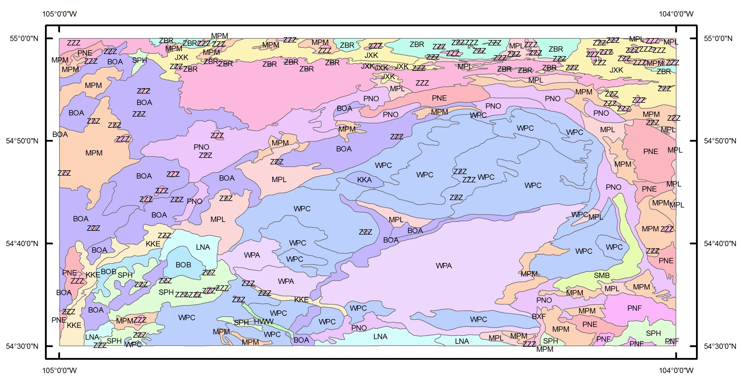
Figure 1. Primary soil units for skd057s.shp. 3-character soil codes are referenced in cansis.txt.
Citation
Knapp, D.E., and H. Rostad. 2016. BOREAS Agriculture Canada Central Saskatchewan Vector Soils Data, R1. ORNL DAAC, Oak Ridge, Tennessee, USA. https://doi.org/10.3334/ORNLDAAC/1346
Table of Contents
- Data Set Overview
- Data Characteristics
- Application and Derivation
- Quality Assessment
- Data Acquisition, Materials, and Methods
- Data Access
- References
- Data Set Revisions
Data Set Overview
This data set provides soil descriptions for forested areas in the BOREAS southern study area (SSA) in central Saskatchewan, Canada provided by Agriculture Canada. The data contain soil code, modifiers, extent, and soil names for the primary, secondary, and tertiary soil units within each polygon.
Boreal Ecosystem-Atmosphere Study: The Boreal Ecosystem-Atmosphere Study was a large-scale international interdisciplinary experiment in the boreal forests of central Canada. Its focus was improving our understanding of the exchanges of radiative energy, sensible heat, water, CO2 and trace gases between the boreal forest and the lower atmosphere. A primary objective of BOREAS was to collect the data needed to improve computer simulation models of the important processes controlling these exchanges so that scientists can anticipate the effects of global change, principally altered temperature and precipitation patterns, on the biome.
Project data set list for Boreal Ecosystem-Atmosphere Study.
Data Characteristics
Spatial Coverage: BOREAS Southern Study Area, in central Saskatchewan, Canada.
Spatial Resolution: Vector data are based on soils maps that were created at a scale of 1:125,000.
Temporal Coverage: The soils were originally mapped in the early 1980s, but the data have been periodically updated by Agriculture Canada based on new information through the date of publication (2001-02-06).
Temporal Resolution: One time representation
Study Area: (all latitudes and longitudes given in decimal degrees)
|
Site (Region) |
Westernmost Longitude |
Easternmost Longitude |
Northernmost Latitude |
Southernmost Latitude |
|
BOREAS SSA |
-110.4511 |
-99.8739 |
55.0614 |
52.8618 |
Data File Information
This data set contains 20 shapefiles and three companion files in comma-separated value format. Each shapefile is provided as a compressed (*.zip) file containing six files (*.shx, *.dbf, *.prj, *.sbn, *.sbx, and *.shp). Shapefile attributes are listed in Table 1. There are three companion files that provide soil descriptions that must be used in conjunction with the shapefiles.
Shapefiles
Spatial Data Properties
Geometry Type: Polygon
Projected Coordinate System: NAD_1927_UTM_Zone_(12, 13, or 14)N
Geographic Coordinate System: GCS_North_American_1927
Datum: D_North_American_1927
Prime Meridian: Greenwich
Angular Unit: Degree
Projection: Transverse_Mercator
false_easting: 500000.00000000
false_northing: 0.00000000
central_meridian: -105.00000000
scale_factor: 0.99960000
latitude_of_origin: 0.00000000
Linear Unit: Meter
Table 1. Descriptions of attributes included in the shapefiles
|
Attribute |
Description |
|
Shape |
Shapefile feature type (polygon) |
|
AREA |
Feature area (m^2) |
|
PERIMETER |
Feature perimeter (m) |
|
PROVINCE |
Province abbreviation |
|
HECTARES |
Feature area in hectares |
|
SOIL_CODE1 |
3-character code for the primary soil name |
|
SOIL_CODE2 |
3-character code for the secondary soil name |
|
SOIL_CODE3 |
3-character code for the tertiary soil name |
|
MODIFIER1 |
3-character code to show soil variations of the primary soil. The modifier applies to the soil name and the soil code. Together with the SOIL_CODE1, a unique record can be identified in the soil name and soil layer file that matches both the SOIL_CODE1 and MODIFIER1 of the polygon. |
|
MODIFIER2 |
3-character code to show soil variations of the secondary soil. The modifier applies to the soil name and the soil code |
|
MODIFIER3 |
3-character code to show soil variations of the tertiary soil. The modifier applies to the soil name and soil code |
|
EXTENT1 |
Percent of the map occupied by a specific soil |
|
EXTENT2 |
Percent of the map occupied by a specific soil |
|
EXTENT3 |
Percent of the map occupied by a specific soil |
Companion Files
The soil names (snf.csv) file and soil layer (skslf.csv) companion files are standard files that provide soil attributes for the province of Saskatchewan. The soil code for each polygon in the ESRI Shapefiles can be linked to the corresponding soil code attribute in the soil names file. The information in the soil names file can be linked to the soil layer file. The soil layer file provides information about the soil strata for a particular soil name. The attributes in the soil name and soil layer files are listed and described in Table 2 and Table 3, respectively. Codes in the soil names and soil layer files can be decoded using using the information contained in the soil codes (cansis.txt) file.
Table 2. The soil names companion file (snf.csv) contains the following information:
|
Column name |
Description |
|
UNKNOWN |
An unknown and undocumented attribute |
|
PROVINCE |
Province name |
|
SOILNAME |
Name of soil |
|
SOIL_CODE |
A 3-character soil code identifying a soil |
|
MODIFIER |
Soil type modifier |
|
LU |
Land use |
|
KIND |
Kind of soil |
|
WATERTBL |
Water table characteristics |
|
ROOTRESTRI |
Soil layer that restricts root growth |
|
REST_TYPE |
Type of root restricting layer |
|
DRAINAGE |
Soil drainage class |
|
MDEP1 |
Mode of deposition for primary soil |
|
MDEP2 |
Mode of deposition for secondary soil |
|
MDEP3 |
Mode of deposition for tertiary soil |
|
ORDER |
Soil order |
|
S_GROUP |
Soil subgroup |
|
G_GROUP |
Great group |
|
PROFILE |
Header from Detail II file |
|
DATE |
Date of last revision |
|
A-THICK |
A horizon thickness |
|
SOL-THICK |
Soil thickness |
|
SOL-CHEM |
Soil chemistry |
|
PM-MODIFY |
Parent material modification |
|
PM-COMPLEX |
Parent material complex |
|
PMDEP2 |
Mode of deposition of second parent material deposition where a soil name is a complex of materials |
|
PM-CHEM |
Parent material chemistry |
|
PMTEXCLASS |
Parent material textural class |
|
TEXMODIFY |
Texture modification |
|
FAMPARTSIZ |
Soil family particle size |
|
PHYSIOG |
Physiography |
Table 3. The soil layer companion file (skslf.csv) contains the following information:
|
Column name |
Description |
|
PROVINCE |
Province abbreviation |
|
SOIL_CODE |
3-character soil code, as in the soil name file (snf.csv). |
|
MODIFIER |
3-character modifier code, as in the soil name file (snf.csv). |
|
LU |
Land use code |
|
LAYER_NO |
Layer number for the soil |
|
HZN_LIT |
Horizon lithological discontinuity * |
|
HZN_MAS |
Master horizon (upper case) * |
|
HZN_SUF |
Horizon suffix (lower case) * |
|
HZN_MOD |
Horizon modifier * |
|
UDEPTH |
Upper horizon depth (cm) |
|
LDEPTH |
Lower horizon depth (cm) |
|
COFRAG |
Coarse fragments (% by volume) |
|
DOMSAND |
Dominant sand fraction: - (Not applicable), VC (Very coarse), C (Coarse), M (Medium), F (Fine), VF (Very fine) |
|
VFSAND |
Very fine sand (% by weight) |
|
TSAND |
Total sand (% by weight) |
|
TSILT |
Total silt (% by weight) |
|
TCLAY |
Total clay (% by weight) |
|
ORGCARB |
Organic carbon (% by weight) |
|
PHCA |
pH in calcium chloride |
|
PH2 |
pH as specified in project report |
|
BASES |
Base saturation (%) |
|
CEC |
Cation exchange capacity (meq/100g) |
|
KSAT |
Saturated hydraulic conductivity (cm/hour) |
|
KP0 |
Water retention at 0 kilopascals ** |
|
KP10 |
Water retention at 10 kilopascals ** |
|
KP33 |
Water retention at 33 kilopascals ** |
|
KP1500 |
Water retention at 1500 kilopascals ** |
|
BD |
Bulk density (g/cm3) |
|
EC |
Electrical conductivity (deciSiemens/meter) |
|
CACO32 |
Calcium carbonate equivalent (%) |
|
VONPOST |
Von Post estimate of decomposition |
|
WOOD |
Volume (%) of woody material |
|
DATE |
Date of last revision |
* Decode this information by referencing the Canadian System of Soil Classification (Soil Classification Working Group, 1998).
** Water retention units are % volume corrected for coarse fragment content.
Application and Derivation
These data might be used for hydrological modeling or some other ecosystem modeling activity.
Users of these data should be cautious about inferring information from this data set and extending those inferences over a larger area. The polygons from the original data set are large and may have small inclusions of various soil types that are not mapped in these data layers.
Quality Assessment
No quality assessment was performed beyond displaying the data set to make sure that it appeared to be a digital soils map covering an area of Saskatchewan.
The source in Canada from whom these data were received has strong caveats about the use of the data. These data represent broad generalizations about the soil characteristics of this area. Caution is to be used when inferring information from the data.
KNOWN PROBLEMS
The original vector data were digitized from aerial photography that was not orthometrically corrected. Therefore, the location accuracy of the soil polygons may not be as accurate as one might expect. Sharp discontinuities may exist along map boundaries. These differences could be a result of coding and mapping variations between adjacent maps.
Data Acquisition, Materials, and Methods
The original vector data were digitized from aerial photography by Agriculture Canada (Padbury and Shields, 1991).
USER NOTE: Data files were received in ARC/INFO EXPORT format (*.e00) and converted to ESRI Shapefile format (*.shp) for distribution with this data set.
Data Access
These data are available through the Oak Ridge National Laboratory (ORNL) Distributed Active Archive Center (DAAC).
BOREAS Agriculture Canada Central Saskatchewan Vector Soils Data, R1
Contact for Data Center Access Information:
- E-mail: uso@daac.ornl.gov
- Telephone: +1 (865) 241-3952
References
Padbury, G.A and J.A. Shields. 1991. Soil Landscapes of Canada-Saskatchewan Soil Landscapes Polygon Attribute Digital Data. CanSIS No. SK018200, version 90.11.30; CLBRR Archive, Agriculture Canada, Research Branch, Ottawa, Canada (CLBRR Contribution No. 91-108D).
Soil Classification Working Group. 1998. The Canadian System of Soil Classification, 3rd ed. Agriculture and Agri-Food Canada Publication 1646, 187 pp. ISBN 0-660-17404-9
Data Set Revisions
Data were previously distributed as:
Knapp, D., and Dr. H. Rostad. 1998. BOREAS/Agriculture Canada Central Saskatchewan Vector Soils Data. ORNL DAAC, Oak Ridge, Tennessee, USA. https://doi.org/10.3334/ORNLDAAC/409
Data files were converted to shapefile format (*.shp) for this distribution. No data values were changed.