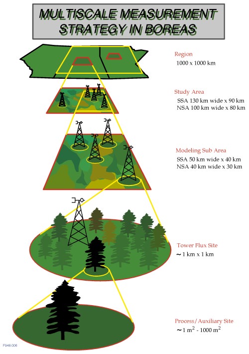
The principal objectives of BOREAS relate to two different spatial scales that must be reconciled within the experiment design. The primary focus of Objective 1 (Introduction) is best addressed by local scale (a few centimeters to a few kilometers) process studies which involve detailed coordinated in-situ observations; e.g., leaf and soil plot scale, CO2 and water flux measurements and tower-mounted eddy correlation. These local-scale studies must be connected to the larger-scale measurement and analysis tools associated with Objective 2 (Introduction) which is directed toward defining regional-scale (10 to 1000 kilometers) fluxes and states. In BOREAS, as in previous field experiments such as FIFE (Sellers et al.; 1992) and HAPEX-Sahel (Goutorbe et al.; 1994), the science team adopted a nested multiscale measurement strategy to integrate observations and process models over a defined range of spatial scales, see Figure 2. At the regional scale, satellite remote sensing, meteorological observations and modeling, and airborne flux measurements provide a large-scale picture of the important processes governing the exchanges of energy, water and carbon between the atmosphere and the land surface. Embedded within the region, data collected from the tower flux sites and process/auxiliary sites are used for point validation while studies carried out at intermediate scales (study area and modeling sub-area scales, see below) will be used to test different integration approaches.
The overall goals of the project emphasize the need to study the biome's biophysical, chemical and ecological functioning under different conditions. The governing climatological variables controlling these in the biome are temperature (associated with length of growing season, radiation budget, etc.) and moisture availability (associated with precipitation, snow hydrology and surface hydrological processes). Essentially, the northern ecotone (transitional boundary) of the forest is delineated by temperature (growing degree days) while the southern boundary is determined by moisture stress and fire frequency in central and western Canada, and by ecological competition with temperate deciduous forest to the east of the Great Lakes. Also, in most of Central Canada, agriculture has pushed up to the southern boundary of the forest. Most global change scenarios predict warming and drying in the mid-continent. A minimum of two intensive study areas is therefore desirable as these allow the observation of processes associated with the controlling factors (temperature in the north, moisture in the south) which are most likely to undergo significant change within the biome as a whole. Two study areas were selected in 1990 with final tower flux sites specified within them in 1992. The Northern Study Area (NSA) is located close to Thompson, Manitoba while the Southern Study Area (SSA), 600 km away to the southwest but almost directly 'downhill' in terms of temperature and precipitation isolines is located near Prince Albert, Saskatchewan, just north of the large agricultural region that lies to the south of the forest.
Each study area covers a domain big enough to allow the acquisition of useful airborne flux measurements and satellite observations but small enough to conserve a reasonable density of surface instrumentation. Almost all of the land surface climatology, nutrient cycling and tropospheric chemistry process studies (i.e. flux towers and other flux measurement efforts) and most of the remote sensing validation work is being conducted within these areas, see Figure 2. The distance between the two study areas is large enough to resolve the ecological gradient but small enough to permit the ferrying of research aircraft and specialized equipment.
