Documentation Revision Date: 2018-12-31
Data Set Version: 1
Summary
This data set includes three data files in *.csv format and one companion file.
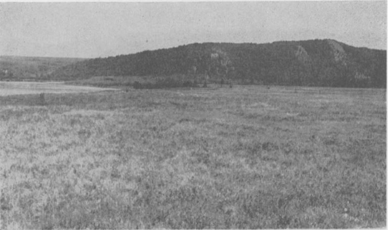
Figure 1. Nome River Valley about 10 miles NE of Nome, Alaska. Dwarf birch-heath-lichens type (medium-dark area to left), Adler type (very dark area on plain near center), Feltleaf willow type (light-colored area background), White spruce shrub type (along river at foot of hill), Alaska white birch-shrubs type (dense forest on hill), White spruce-Alaska white birch shrub type (open stands), Cottongrass-sedge dwarf heath shrub complex (distance at left)
Citation
Hanson, H.C. 2018. Arctic Vegetation Plots at Nome, Alaska, 1951. ORNL DAAC, Oak Ridge, Tennessee, USA. https://doi.org/10.3334/ORNLDAAC/1372
Table of Contents
- Data Set Overview
- Data Characteristics
- Application and Derivation
- Quality Assessment
- Data Acquisition, Materials, and Methods
- Data Access
- References
Data Set Overview
This data set provides environmental, soil, and vegetation data collected in July and August 1951 from 80 study plots in the Nome River Valley about 10 miles northeast of Nome, Alaska on the Seward Peninsula. Data includes the baseline plot information for vegetation, soils, and site factors for the study plots subjectively located in plant communities that were found to occur in 5 broad habitat types across the glaciated landscape. Specific attributes include: dominant vegetation species and cover, and soil characteristics, moisture, and organic matter. This product brings together for easy reference all the available information collected from the plots that has been used for the classification, mapping and analysis of geo-botanical factors in the Nome River Valley and across Alaska.
The Pre-ABoVE vegetation plot datasets were curated to create the Alaska Arctic Vegetation Archive (AVA-AK; Walker et al. 2016b, Walker 2013). The AVA-AK is a regional database that is part of the larger Arctic Vegetation Archive (Walker 2016a, Walker et al. 2013, Walker and Raynolds 2011). The database contains vegetation plots from homogeneous plant communities with tables of cover or cover-abundance scores for all species and accompanying environmental site data. Field data were collected using Braun-Blanquet, US National Vegetation Classification protocols, or comparable methods.
Project: Arctic-Boreal Vulnerability Experiment (ABoVE)
The Arctic-Boreal Vulnerability Experiment (ABoVE) is a NASA Terrestrial Ecology Program field campaign that will take place in Alaska and western Canada between 2016 and 2021. Climate change in the Arctic and Boreal region is unfolding faster than anywhere else on Earth. ABoVE seeks a better understanding of the vulnerability and resilience of ecosystems and society to this changing environment.
Acknowledgements:
These data files were edited by Donald A. Walker, Amy L. Breen and Lisa A. Druckenmiller at the University of Alaska Fairbanks' Alaska Geobotany Center and obtained via the Arctic Geoecological Atlas (http://arcticatlas.geobotany.org/), which provides access to existing Arctic vegetation plot and map data in support of the ABoVE campaign.
Data Characteristics
Spatial Coverage: Nome, Alaska
ABoVE Grid Location: Ah0v0Bh3v1
Spatial Resolution: Point samples
Temporal Coverage: 19510730 to 19510802
Temporal Resolution: Each plot was sampled once
Study Area: (All latitude and longitude given in decimal degrees)
|
Site |
Westernmost Longitude |
Easternmost Longitude |
Northernmost Latitude |
Southernmost Latitude |
|
Nome river valley, northeast of Nome, Alaska |
-165.264 |
-165.264 |
64.629 |
64.629 |
Data File Information
This data set includes three data files in .csv format and one companion file. File contents are described in Table 1.
Table 1. Data and companion files
| Data File Name | Description |
| Nome_Soil_Data.csv | Soil characterization data for Nome research plots |
| Nome_Environmental_Data.csv | Comprehensive set of environmental characterization data for Nome research plots including descriptive site factors. Most measurement data have been processed to provide values at a common 10 cm depth. This measurement comparability facilitates analysis of geo-botanical relationships across Alaska. |
| Nome_Species_Data.csv | Species cover data collected in 1951 for research plots near Nome, Alaska |
| Companion File Name | Description |
| Nome_Veg_Plots_Photos.pdf | Landscape, plot, and soil photos of the Nome vegetation plots |
Data Descriptions: The column names, their units, and descriptions for each of the .csv data files are listed below.
Table 2. Nome_Soil_Data.csv
| Column Name | Units | Description |
| PUBLISHED_PLOT_NUMBER | TABLE_NUMBER-PLOT_NUMBER | Roman numeral corresponding to the table number from Hanson (1953) and plot number where the soil was sampled. Each table provides data for a different site in the vicinity of Nome, Alaska. |
| DATE | YYYYMMDD | Sampling date |
| SOIL_DESCRIPTION | Description of soil observed at the plots | |
| SOIL_MOISTURE | Soil moisture content within the plots | |
| PH | pH of the soil within the plots |
Table 3. Nome_Environmental_Data.csv
| Column Name | Units | Description |
| TABLE_PLOT_NUMBER | TABLE_NUMBER-PLOT_NUMBER | Roman numeral corresponding to the table from Hanson (1953) and plot number where the soil was sampled. Each table provides data for a different site in the vicinity of Nome, Alaska. |
| DATE | YYYYMMDD | Sampling date |
| LOCATION | Location of the plots | |
| STAND_SIZE | Size of stands where plots were sampled | |
| SLOPE | DEGREES | Slope of the plots |
| ASPECT | Aspect of the slots | |
| ELEVATION | FEET | Elevation of the plots |
| SOIL_MOISTURE | Soil moisture content within the plots | |
| PH | pH of the soil within the plots | |
| COMMUNITY_TYPE_SUBTYPE | Vegetation community type | |
| COMMUNITY_DESCRIPTION | Description of vegetation community | |
| HAB_TYPE | Habitat type codes corresponding to type codes detailed in Hanson (1953), pages 113-114 | |
| SITE_MST | Site moisture: MST or DRY | |
| MOSS_COVER_CODE | * | Moss cover in the plot |
| LICHEN_COVER_CODE | * | Lichen cover in the plot |
| ROCK_COVER_WITH_CRUSTOSE_LICHENS_CODE | * | Rock cover with crustose lichens in the plot |
| BARE_GROUND_COVER_CODE | * | Bare ground cover in the plot |
| SOIL_DESCRIPTION | Soil description | |
| SPECIES_NAME_CHANGES | Changes to species names before entry to TURBOVEG |
* Cover codes are applied based on a modified Hult-Sernander species abundance scale where: 1 (covers less than 1/6 of the area or 4 percent), 2 (covers 1/16 to 1/8 or 9 percent), 3 (covers 1/8 to 1/4 or 18 percent), 4 (covers 1/4-1/2 or 38 percent), 5 (covers 1/2 to 3/4 or 63 percent), 6 (covers 3/4 to 4/4 or 87 percent).
Table 4. Nome_Species_Data.csv
| Column Numbers | Column Name | Units | Description |
| 1 | PASL_TAXON_SCIENTIFIC_NAME_NO_AUTHORS | Current Taxonomy according to the Panarctic Species List (PASL) | |
| 2 | PASL_TAXON_SCIENTIFIC_NAME_WITH_AUTHOR(S) | Current Taxonomy according to the Panarctic Species List (PASL) includng authors names | |
| 3 | DATASET_TAXON | Dataset taxonomy | |
| 4 to 84 |
TABLE_NUMBER-PLOT_NUMBER e.g. TBL_I-1, TBL_1-2, etc., where Roman numerals I through VIII correspond to the tables in Hanson (1953) and 1 through 10 correspond to the plot number. |
Column headings are the 80 table/plot numbers. The data values are species cover classes (modified Hult-Sernander cover-abundance scale) where: + (trace, 0.5 percent), 1 (covers less than 1/6 of the area or 4 percent), 2 (covers 1/16 to 1/8 or 9 percent), 3 (covers 1/8 to 1/4 or 18 percent), 4 (covers 1/4-1/2 or 38 percent), 5 (covers 1/2 to 3/4 or 63 percent), 6 (covers 3/4 to 4/4 or 87 percent). |
Application and Derivation
These data bring together for easy reference all the available information collected from the plots that has been used for the classification, mapping, and analysis of the geo-botanical factors in the region near Nome, Alaska. Derived regional maps of these data will be used in regional models of fluxes of trace gases, water, and energy from tundra surfaces. In addition, a circumpolar vegetation classification resulting from these data sets would be highly desirable to extend the results to the entire Arctic region.
These data were originally collected as part of a classification of the major vegetation types during broader surveys for reindeer winter lichen range in northwestern Alaska. The work was funded by the Arctic Institute of North America with funds provided by the Office of Naval Research. Classification of the major kinds of vegetation was needed to show relationships between the distribution and abundance of lichens and the major vegetation types which could be readily distinguished on the ground or from the air. Hanson (1953) noted the similarities of the Alaskan vegetation communities to those in other arctic and sub-arctic regions, particularly Scandinavia.
Quality Assessment
No specific quality assessment information provided.
Data Acquisition, Materials, and Methods
Sampling of tundra vegetation on the Seward Peninsula near Nome, Alaska was undertaken as part of a classification of the major vegetation types during broader surveys for reindeer winter lichen range in northwestern Alaska. The primary source document for this data set is Hanson (1953).
In July and August of 1951, plant species data were collected from 80 subjectively located plots to align with methods used for vegetation sampling in northern Europe (Braun-Blanquet 1932). Within stands, ten 1-m2 plots were located at regular intervals on a line through each stand and species cover was recorded using a modified Hult-Sernander scale (Hanson 1953). Plant communities were found to occur in 5 broad habitat types including: Moist to wet acidic tussock and non-tussock tundra (Eriophorum vaginatum-Carex bigelowii-Sphagnum-Hylocomium; 10 plots), Dry acidic prostrate-shrub heaths (Arctous alpina, Salix phlebophylla, Empetrum heaths; 10 plots), shallow acidic snowbeds (Cassiope-Carex microchaeta-Hylocomium communities; 10 plots), moist and dry acidic dwarf-shrub heaths (Vaccinium uliginosum, Empetrum nigrum, Ledum decumbens, some Betula nana-lichen heaths; 30 plots), and dry acidic tundra (Dryas octopetala; 20 plots).
Stands were not permanently marked and little environmental data was recorded, however select soil descriptions were included. Plot numbers in the environmental, soil, and species data files were assigned by their respective table numbers (Hanson 1953: Tables I-VIII) and plot numbers within the tables.
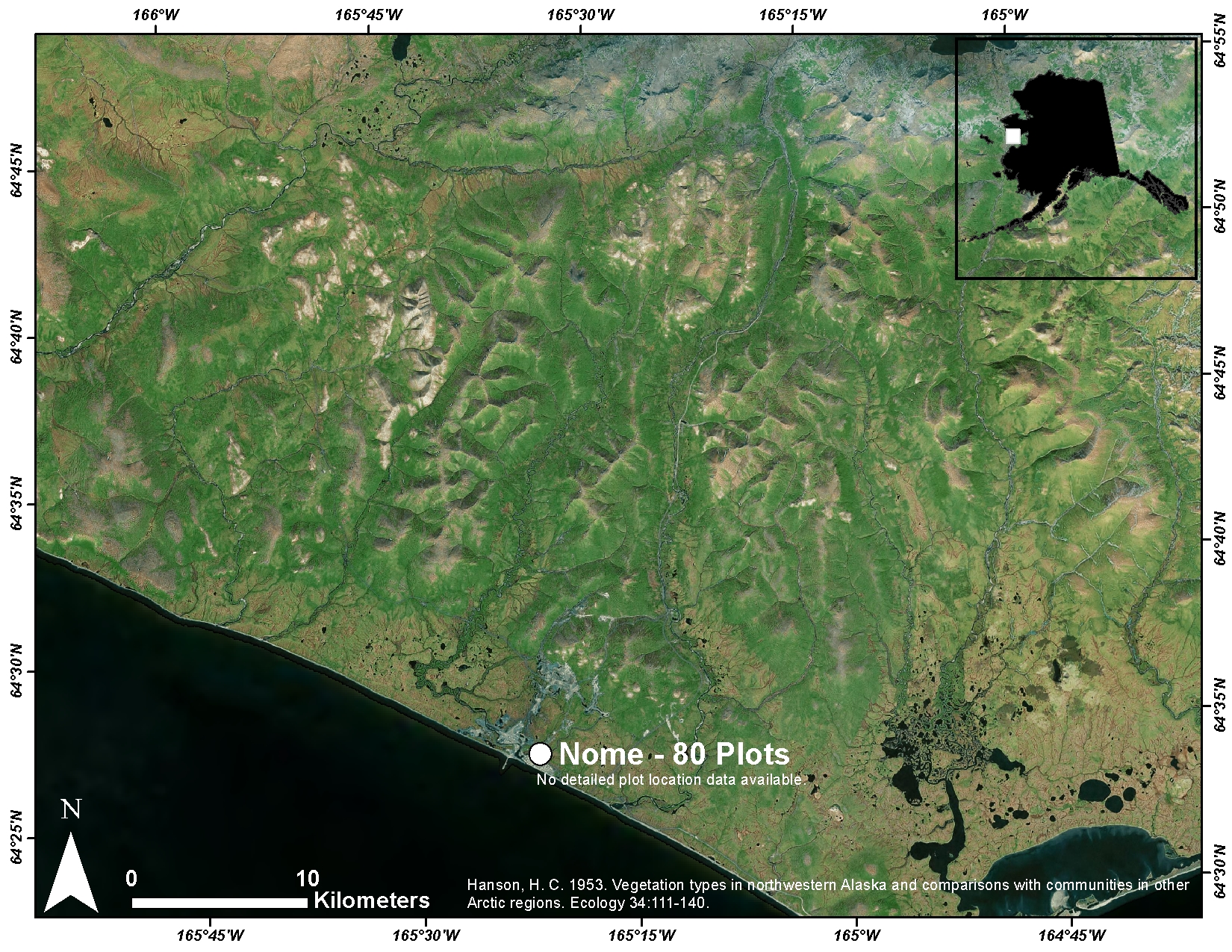
Figure 2. Presumed location of vegetation plots observed by Hanson in 1951 near Nome, Alaska. Verbal descriptions from Hanson (2013) indicate that all plots were located within roughly 13 miles of Nome.
Data Access
These data are available through the Oak Ridge National Laboratory (ORNL) Distributed Active Archive Center (DAAC).
Arctic Vegetation Plots at Nome, Alaska, 1951
Contact for Data Center Access Information:
- E-mail: uso@daac.ornl.gov
- Telephone: +1 (865) 241-3952
References
Braun-Blanquet, J. 1932. Plant sociology. 439 pp. McGraw-Hill, New York.
Hanson, H. C. 1953. Vegetation types in northwestern Alaska and comparisons with communities in other Arctic regions. Ecology 34:111-140.
Walker, D.A., Daniëls, F.J.A., Alsos, I., Bhatt, U.S., Breen, A.L., Buchhorn, M., Bültmann, H., Druckenmiller, L.A., Edwards, M.E., Ehrich, D., Epstein, H.E., Gould, W.A., Ims, R.A., Meltofte, H., Raynolds, M.K., Sibik, J., Talbot, S.S. and Webber, P.J. 2016. Circumpolar arctic vegetation: A hierarchic review and roadmap toward an internationally consistent approach to survey, archive and classify tundra plot data. Environmental Research Letters. 11:055005. doi: 10.1088/1748-9326/11/5/055005.
Walker, D. A.; A. L. Breen; L. A. Druckenmiller; L. W. Wirth; W. Fisher; M. K. Raynolds; J. Šibík; M. D. Walker; S. Hennekens; K. Boggs; T. Boucher; M. Buchhorn; H. Bültmann; D. J. Cooper; F. J.A Daniëls; S. J. Davidson; J. J. Ebersole; S. C. Elmendorf; H. E. Epstein; W. A. Gould; R. D. Hollister; C. M. Iversen; M.T. Jorgenson; A. Kade; M. T. Lee; W. H. MacKenzie; R. K. Peet; J. L. Peirce; U. Schickhoff; V. L. Sloan; S. S. Talbot; C. E. Tweedie; S. Villarreal; P. J. Webber; D. Zona. The Alaska Arctic Vegetation Archive. 2016b. Phytocoenologia. doi: http://dx.doi.org/10.1127/phyto/2016/0128
Walker, D.A. (Ed). Alaska Arctic Vegetation Archive Workshop, Boulder, Colorado, October 14-16, 2013. CAFF Proceedings Report #11. Akureyri, Iceland. ISBN: 978-9935-431-29-5.
Walker, D. A., A. L. Breen, M. K. Raynolds, and M. D. Walker, editors. 2013. Arctic Vegetation Archive Workshop, Krakow, Poland April 14-16, 2013. CAFF Proceedings Report #10. Akureyri, Iceland. ISBN: 978-9935-431-24-0.
Walker, D. A., and M. K. Raynolds. 2011. An International Arctic Vegetation Database: A foundation for panarctic biodiversity studies. CAFF Strategy Series Report nr. 5. Conservation of Arctic Flora and Fauna (CAFF), Akureyri, Iceland.