Documentation Revision Date: 2016-12-12
Data Set Version: V1
Summary
Unlike open water maps derived from satellite optical-infrared remote sensing, the fractional water record benefits from strong microwave brightness temperature sensitivity to surface water and relative insensitivity to potential data loss from cloud cover and atmosphere aerosol contamination, and conditions of low solar illumination which are prevalent in Arctic environments.
There are 469 data files in GeoTIFF (.tif) format for the pan-Arctic region and 469 files for the ABoVE study domain. Each file represents the average over a ten-day period. There are also two data quality files in GeoTIFF (.tif) format, one for each region, for a total of 940 files.
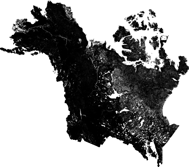
Figure 1. Land surface fractional open water for the extended ABoVE domain for Julian days 171-180 of 2002 depicted with a black to white gradient.
Citation
Du, J., J.S. Kimball, and J.D. Watts. 2016. ABoVE: Fractional Open Water Cover for Pan-Arctic and ABoVE-Domain Regions, 2002-2015. ORNL DAAC, Oak Ridge, Tennessee, USA. http://dx.doi.org/10.3334/ORNLDAAC/1362
Table of Contents
- Data Set Overview
- Data Characteristics
- Application and Derivation
- Quality Assessment
- Data Acquisition, Materials, and Methods
- Data Access
- References
Data Set Overview
This data set provides land surface fractional open water cover maps for two overlapping regions: the entire pan-Arctic region (latitude > 45 degrees) and the defined Arctic-Boreal Vulnerability Experiment (ABoVE) domain across Alaska and Canada. The data represent a fractional water average over a 10-day time step at 5-km spatial resolution for the period 2002-2015. Data represent the aerial portion of a grid cell covered by open water. The data were produced using high frequency (89 GHz) brightness temperatures from the Advanced Microwave Scanning Radiometer for EOS (AMSR-E) and the Advanced Microwave Scanning Radiometer 2 (AMSR2), with other ancillary inputs from AMSR-E/AMSR2 25-km products and the Moderate Resolution Imaging Spectroradiometer (MODIS). The resulting data record for fractional water is suitable for documenting open water patterns and inundation dynamics in boreal-Arctic ecosystems experiencing rapid climate change.
Unlike open water maps derived from satellite optical-infrared remote sensing, the fractional water record benefits from strong microwave brightness temperature sensitivity to surface water and relative insensitivity to potential data loss from cloud cover and atmosphere aerosol contamination, and low solar illumination.
Project: Arctic-Boreal Vulnerability Experiment (ABoVE)
The Arctic-Boreal Vulnerability Experiment (ABoVE) is a NASA Terrestrial Ecology Program field campaign based in Alaska and western Canada between 2016 and 2021. Climate change in the Arctic and Boreal region is unfolding faster than anywhere else on Earth. ABoVE seeks a better understanding of the vulnerability and resilience of ecosystems and society to this changing environment.
Related Publications:
Du, J., J.S. Kimball, L.A. Jones, and J.D. Watts. 2016. Implementation of satellite based fractional water cover indices in the pan-Arctic region using AMSR-E and MODIS. Remote Sensing of Environment, 184: 469-481. doi: 10.1016/j.rse.2016.07.029
Data Characteristics
Spatial Coverage:
(a) pan-Arctic region: Northern hemisphere above 45 degrees latitude
(b) ABoVE Domain: Core and extended ABoVE study regions
ABoVE Grid Cells: Ah0v0, Ah1v0, Ah2v0, Ah3v0, Ah0v1, Ah1v1, Ah2v1, Ah3v1, Ah1v2, Ah2v2, Ah3v2, Ah2v3, Ah3v3
Spatial Resolution: 5 km
Temporal Coverage (YYYYMMDD): 20020620 - 20111004 and 20120719 - 20151231
Temporal Resolution: 10 day
Study Area: (All latitude and longitude given in decimal degrees)
|
Site |
Westernmost Longitude |
Easternmost Longitude |
Northernmost Latitude |
Southernmost Latitude |
|
pan-Arctic |
-180.000 |
180.000 | 90.000 | 45.000 |
|
ABoVE domain |
-176.125 |
-66.752 | 81.609 | 39.383 |
GeoTIFF Spatial Data Properties
pan-Arctic
Spatial Representation Type: Raster
Data Type: 2-byte integer
Number of Bands: 1
Number Columns: 1957
Column Resolution: 5000 meter
Number Rows: 1957
Row Resolution: 5000 meter
Fill value: -999
Projection: EASE-GRID Version 2 (Brodzik et al., 2014)
Datum: WGS_1984
ABoVE domain
Spatial Representation Type: Raster
Data Type: 2-byte integer
Number of Bands: 1
Number Columns: 805
Column Resolution: 5000 meter
Number Rows: 713
Row Resolution: 5000 meter
Fill value: -999
Projection: Canada Albers projection
Datum: NAD83
Data File Information
There are 469 data files in GeoTIFF (.tif) format for the pan-Arctic region and 469 files for the ABoVE study domain. Each file represents the average over a ten-day period.
The fractional water cover data files are named by study domain and temporal coverage, such as:
domain_FW_YYYY_SSS_EEE.tif
where domain = either PanArctic or ABoVE
YYYY = year
SSS = day of the year at the start of the ten day period
EEE = day of the year at the end of the ten day period
Example file names:
- PanArctic_FW_2002_271_280.tif - contains fw data for the pan-Arctic domain for 2002, day of the year 271 to 280.
- ABoVE_FW_2002_271_280.tif - contains fw data for the ABoVE domain for 2002, day of the year 271 to 280.
The two additional data quality files (QA), one each for the ABoVE domain and pan-Arctic region, provide information regarding: (a) retrievable pixels within the study domain; (b) ocean areas excluded from the fractional water (fw) retrievals; (c) land-ocean boundary pixels subjected to larger fw retrieval errors; (d) non-retrievable pixels including those within large water bodies (i.e. water area > 312.5 km2), frozen conditions or with permanent ice/snow cover; and (e) areas outside of the product domain. Class definitions for the QA files are listed in Table 1.
ABoVE_FW_QA.tif and PanArctic_FW_QA.tif are quality flag files for the ABoVE domain and pan-Arctic, respectively. The QA data are in the same format as the corresponding Spatial Data except that data type is byte.
Table 1. Class definitions for QA files
| Cell Value | Definition |
| 0 | Retrievable land |
| 1 | Ocean |
| 2 | Ocean-land boundary |
| 3 | Non-retrievable land pixels |
| 255 | Land areas outside of retrieval domain |
Application and Derivation
This data set provides an improved resolution satellite environmental data record documenting open water patterns and inundation dynamics in boreal-Arctic ecosystems experiencing rapid climate change. Accurate estimation of open water dynamics has become a prerequisite for strengthening the current understanding of northern high latitude ecosystems and carbon cycle related feedbacks to climate change.
Quality Assessment
Three fine-scale static open water maps were used to evaluate this fw data set:
1) the 30-m Global Land 30-water 2010 (GLC30; Liao et al., 2014), derived from Landsat TM/ETM+ imagery and HJ-1 sensors collected over the 2010 base year;
2) the 300-m ENVISAT Advanced Synthetic Aperture Radar (ASAR) Global Water Bodies map (ASAR300; Kirches et al., 2014), derived from multi-temporal ASAR acquisitions in wide swath mode for years 2005 to 2010;
3) the 250-m MOD44W product (Carroll et al., 2009), derived from a compilation of the SRTM Water Body data set and the MODIS (MOD44C) Collection 5 (2000-2008) open water classification product.
The AMSR-E fw summer seasonal composites from 2003 to 2010 correspond favorably (R ≥ 0.86, p < 0.001) with the fine resolution static open water maps, as shown in Figure 2. The fw retrievals capture significant seasonal drought and flooding events inferred from river discharge records within the major Arctic basins (Du et al., 2016). They are found to be reliable for discriminating open water in moderately dense vegetation areas, but with greater uncertainty over barren land. The ability of the fw retrievals to detect surface water under vegetation decreases exponentially with increasing canopy optical thickness (Du et al., 2016). In addition, AMSR2 brightness temperature has been calibrated against AMSR-E, but the impacts of different sensor spatial resolutions and instrument calibration systems on fw retrievals cannot be completely removed. Possible retrieval biases may exist between the AMSR-E and AMSR2 retrievals.
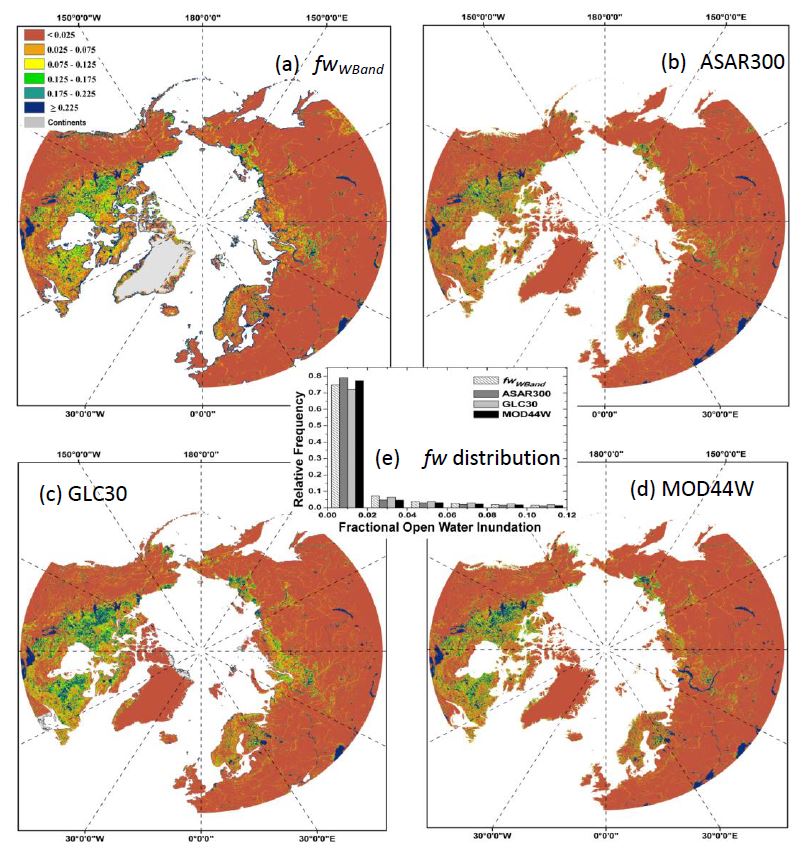
Figure 2. a) Mean fractional open water map generated at 5-km resolution from AMSR-E 89 GHz observations (fwWBand); the fwWBand results are presented for the 2006 reference year and mean summer conditions (June, July, August); reference fw maps generated from other finer resolution satellite data records include: (b) 300-m resolution ASAR300, (c) 30-m GLC30, and (d) 250-m MOD44W land cover maps. e) Histogram of fractional open water distributions of the fwWBand, ASAR300, GLC300, and MOD44W maps. From Du et al., 2016.
Data Acquisition, Materials, and Methods
The data set was generated using 89 GHz brightness temperature (Tb) retrievals from calibrated AMSR-E and AMSR2 sensor records under dynamic atmospheric and land surface conditions defined by three geospatial data sets (Du et al., 2016). The general workflow is depicted in Figure 3.
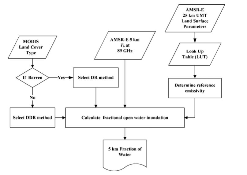
Figure 3. General data processing flowchart describing the methodology used to derive the 5-km resolution fractional open water inundation retrieval from AMSR-E/2 89 GHz Tb and the 25-km UMT Land Parameter data record. A difference ratio method was applied to classified barren land pixels and a double difference ratio method was used for vegetated pixels.
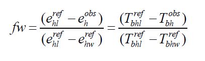
The AMSR2 multifrequency Tb retrievals were calibrated against similar Tb retrievals from AMSR-E using overlapping Tb observations from the Microwave Radiation Imager (MWRI) onboard the Chinese FY3B satellite using an empirical approach (Du et al., 2014). The ancillary data sets used for algorithm development include the University of Montana AMSR-E/2 global land parameter record (Jones and Kimball, 2012; Jones et al., 2010); a AMSR-E/2 frequency ratio data record defined as the V- and H-polarization difference ratio between 89 and 36 GHz channels; and a MODIS 1-km resolution global land cover classification (MOD12Q1) derived using the IGBP classification scheme (Friedl et al., 2006). Based on the above data sets, a look-up table was established to provide reference microwave emissivities for water and land endmembers under a range of atmosphere and land surface conditions. The fw retrievals were then obtained on a per pixel basis as described by Equations 1 and 2:
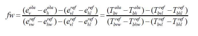
where:
Tbpobs represents the actual satellite Tb observation for p (either H or V) polarization,
Tbpwref denotes the Tb from the reference water endmember pixel, and
Tbplref is the Tb from the reference land endmember pixel.
The corresponding variable emissivity terms are expressed as ebpobs, epwref, and eplref respectively. For barren land conditions, fw is determined using a Difference Ratio of only H-polarization emissivities:
Data Access
These data are available through the Oak Ridge National Laboratory (ORNL) Distributed Active Archive Center (DAAC).
ABoVE: Fractional Open Water Cover for Pan-Arctic and ABoVE-Domain Regions, 2002-2015
Contact for Data Center Access Information:
- E-mail: uso@daac.ornl.gov
- Telephone: +1 (865) 241-3952
References
Brodzik, M.J., B. Billingsley, T. Haran, B. Raup, and M.H. Savoie. 2014. Correction: Brodzik, M.J. et al. EASE-Grid 2.0: Incermental but Significant Improvements for Earth-Gridded Data Sets. ISPRS Int. J. Geo-Inform. 3: 1154-1156.
Carroll, M., J. Townshend, C. Dimiceli, P. Noojipady, and R. Sohlberg. 2009. A New Global Raster Water Mask at 250 Meter Resolution. Int. J. Digital Earth 2: 291-308.
Du, J., J.S. Kimball, J. Shi, et al. 2014. Inter-calibration of satellite passive microwave land observations from AMSR-E and AMSR2 using overlapping FY3B-MWRI sensor measurements. Remote Sensing 6: 8594-8616.
Du, J., J.S. Kimball, L.A. Jones, and J.D. Watts. 2016. Implementation of satellite based fractional water cover indices in the pan-Arctic region using AMSR-E and MODIS. Remote Sens. Environ. 85: 32-338.
Friedl, M.A., D. Sulla-Menashe, B. Tan, A. Schneider, N. Ramankutty, A. Sibley, and X. Huang. 2006. MODIS Collection 5 global land cover: Algorithm refinements and characterization of new datasets. Remote Sens. Environ. 114: 168-182.
Jones, L.A., C.R. Ferguson, J.S. Kimball, K. Zhang, S.T.K. Chan, K.C. McDonald, E.G. Njoku, and E.F. Wood. 2010. Satellite microwave remote sensing of daily land surface temperature minima and maxima from AMSR-E. IEEE J. Sel. Top. Appl. Earth Obs. Remote Sens. 3: 111-123.
Jones, L.A., and J.S. Kimball. 2012. Daily Global Land Surface Parameters Derived from AMSR-E, Version 1, Boulder Colorado USA: National Snow and Ice Data Center. 2010. Digital media. http://dx.doi.org/10.5067/JIKQZ6WO5C5M.
Kirches, G., C. Brockmann, M. Boettcher, M. Peters, E. Bontemps et al. 2014. CCI-LC Product User Guide Version 2. Document Reference CCI-LC-PUG, 2014-19-02, 87.
Liao, A.P., L.J. Chen, J. Chen, C.Y. He, X. Cao, J. Chen, S. Peng, F.D. Sun, and P. Gong. 2014. High-resolution remote sensing mapping of global land water. Science China Earth Sci. 57: 2305-2316.