Get Data
Summary:
This data set consists of a 1:15 million scale forest cover map for the land area of the Former Soviet Union (FSU). Twenty-two land cover classes are distinguished, twenty of which are forest cover classes. The source data were created by map digitization from the Atlas of Forests of the USSR (Anon. 1973), which was likely based on forestry data from the 1940s, 1950s, and 1960s.
The data are provided in several formats, including binary raster data in Idrisi format, ASCIIGRID raster data in ASCII format (easily imported into ArcInfo), and a graphic map in JPEG format (see Figure 1). Please read all documentation before using these files.
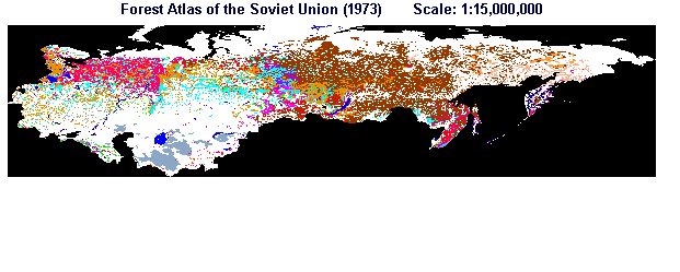
Figure 1. Forest cover map for the land area of the Former Soviet Union. State Committee on Forests (1973). Scale: 1:15,000,000
Data Citation:
Cite this data set as follows:
Stone, T. A., and P. Schlesinger. 2003. RLC Forest Cover of the Former Soviet Union, 1973. Data set. Available on-line [http://www.daac.ornl.gov] from Oak Ridge National Laboratory Distributed Active Archive Center, Oak Ridge, Tennessee, U.S.A. doi:10.3334/ORNLDAAC/692.
Table of Contents:
- 1 Data Set Overview
- 2 Data Characteristics
- 3 Applications and Derivation
- 4 Quality Assessment
- 5 Acquisition Materials and Methods
- 6 Data Description and Access
- 7 References
- 8 Glossary and Acronyms
- 9 Document Information
1. Data Set Overview:
Data Set Contents:
This data set consists of a 1:15 million scale forest cover map for the land area of the FSU. Twenty-two land cover classes are distinguished.
Related Data Sets:
See other Russian Land Cover data sets.
Title of Investigation:
Measuring Changes to Russian Forest Over the Last 25 Years
Investigator(s) Name and E-mail:
Name Stone, T.A. tstone@whrc.org Schlesinger, P. pschles@whrc.org
Technical Contact(s) Name, Telephone, and E-mail:
Name Phone Schlesinger, P. pschles@whrc.org (508)540-9900
Future Modifications and Plans:
Not available
2. Data Characteristics:
Study Area:
Spatial Coverage:
Min. X: 19.81647
Max. X: -190.0245
Min. Y: 35.16593
Max. Y: 75
In decimal degrees of latitude and longitude
Spatial Resolution:
Source data (scale 1:15 million)
Projection:
Geographic
Grid Description:
Cols: 1183
Rows: 277
Resolution: 0.14387301
Temporal Coverage:
Map based on forestry data from the 1940s, 1950s, and 1960s
Parameter or Variable:
Table for: A binary raster image depicting forest cover
Variable Description Units Instrument Range LAND COVER Forest land cover Unitless Atlas of Forests of the USSR (1973) Not applicable
LAND COVER footnote: Forest categories used on the map:
Category 0 : Off Map
Category 1 : Pine
Category 2 : Spruce
Category 3 : Fir
Category 4 : Spruce/Fir
Category 5 : Larch
Category 6 : Siberian Pine
Category 7 : Juniper/Woodland
Category 8 : Krumholz
Category 9 : Oak
Category 10 : Beech/Hornbeam
Category 11 : Subarctic Birch
Category 12 : Haloxylon
Category 13 : Birch
Category 14 : Aspen
Category 15 : Nonforest
Category 16 : Water
Category 17 : Sparse Pine
Category 18 : Sparse Spruce
Category 19 : Sparse Fir
Category 31 : Lime/Tilia
Category 33 : Other Hardwood
Category 39 : Sparse Trees/Stands of Larch
Table for: An ASCIIGRID version of the binary raster data.
Variable Description Units Instrument Range LAND COVER Forest land cover Unitless Atlas of Forests of the USSR (1973) Not applicable LAND COVER footnote: Forest categories used on the map are listed above.
Data Organization
Please read all documentation before using these files: http://daac.ornl.gov/daacdata/russian_land_cover/forest_map_1973/comp/fmap73_readme.txt and http://daac.ornl.gov/daacdata/russian_land_cover/forest_map_1973/comp/fmap73_projection.txt.
Granule Name or Description:
fmap73.img
Data Format:
The file is an Idrisi v. 2 image file, a binary raster image depicting forest cover (1973). Note: must be converted to an *rst file when using v. 3.2 of Idrisi. Use the Idrisi File Conversion (16/32) utility available in the file pulldown menu to convert to the new format. Also note that the Idrisi v. 2 image documentation file, fmap73.doc, MUST be present for the binary data to be read by Idrisi.
Sample Data Record:
Not applicable
Granule Name or Description:
fmap73.dat
Data Format:
The file is an ASCIIGRID version of the binary raster data (fmap73.img). This data file was created by converting the Idrisi binary file (fmap73.img) using Idrisi export utilities. Note: it was necessary to first convert the *.img file to a *rst file and the *doc file to an *rdc file to match the new file format and naming convention of raster data supported by Idrisi v. 3.2.
Sample Data Record:
Not applicable
3. Application and Derivation:
Typical Application of Data:
Regional-, national-, and sub-national-level forest and land use change assessments
Theory of Measurements:
Not available
Derivation Techniques and Algorithms:
Formulae:
Not available
Processing Steps:
The source data for the raster version of the 1973 Forests of the USSR (being distributed here) were acquired by map digitization from the Atlas of Forests of the USSR (1973). These data were projected from conic equidistant projection to geographic using PC ArcInfo using the PROJECT command.
Processing Changes:
Not applicable
Special Corrections/Adjustments:
Not applicable
Calculated Variables:
Not applicable
Graphs and Plots Used in Analysis:
Not applicable
4. Quality Assessment:
Data Usage Guidance:
These data are in modified geographic coordinates. Thus, Eastern Russia extends past 180 degrees longitude to accommodate a smaller computer screen and to facilitate easier modeling.
Errors and Limitations:
Error Sources:
Not applicable
Limitations of the Data:
Not applicable
Known Problems with the Data:
Not applicable
Quality Assessment Activities
Not available
Other Relevant Information about the Study:
Not available
5. Acquisition Materials and Methods:
Source or Platform Collection Environment:
Not available
Source or Platform Program Management:
Not available
Source or Platform Mission Objectives:
Coverage Information:
Not available
Attitude Characteristics:
Not available
Data Collection System:
Not available
Communication Links:
Not available
List of Sensors or Instruments:
Analysis
Ground Segment Information:
Data Acquisition and Processing:
Not available
Latitude Crossing Times:
Not available
Sensor or Instrument Descriptions
Key Variables:
Not available
Principles of Operation:
Not available
Sensor or Instrument Measurement Geometry:
Not available
Manufacturer of Sensor or Instrument:
Not available
Calibration:
Specifications:
Not applicable
Tolerance:
Not applicable
Frequency of Calibration:
Not applicable
Other Calibration Information:
Not applicable
Data Acquisition Methods:
Observations
Data Notes:
Not available
6. Data Description and Access:
Data Access:
This data set is available through the Oak Ridge National Laboratory (ORNL) Distributed Active Archive Center (DAAC).
Data Archive Center:
Contact for Data Center Access Information:
E-mail: uso@daac.ornl.gov
Telephone: +1 (865) 241-3952
FAX: +1 (865) 574-4665
Product Availability:
Data can be accessed electronically on the ORNL DAAC's anonymous HTTP site or from the DAAC's search and order system. Data files are also available by request from uso@daac.ornl.gov.
Reading the Media:
Not applicable
Software and Analyses Tools:
Idrisi
7. References:
Anon. 1973. Atlas of Forests for the Soviet Union, Main Geodetic and Cartographic Organization for the Ministries of the USSR, Moscow, 222 pp.
State Committee on Forests. 1973. A 1:15,000,000 scale forest cover map of FSU from 1973 Russian Forest Atlas. Soviet Ministry of Geodesy and Cartography.
8. Glossary and Acronyms:
Glossary:
Not available
Acronyms:
| Acronym | Definition |
| ASCII | American Standard Code for Information Interchange |
| JPEG | Joint Photographic Experts Group |
9. Document Information:
2003/11/26
Document Review Date:
2003/11/26
Document Curator:
webmaster@www.daac.ornl.gov