Get Data
Summary:
This data set of state and regional boundaries was derived from the 1:3 million scale administrative boundaries (ESRI 1998) for the land area of the Former Soviet Union (FSU). There are 162 administrative regions distinguished in this data set. The vector map of state and regional boundaries for the FSU is in ArcView shapefile format. A graphic map depicting the administrative boundaries is also included (Figure 1).
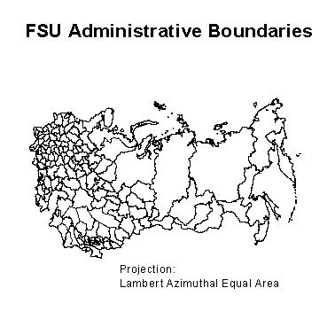
Figure 1. State and Regional Boundaries for the Former Soviet Union. Scale 1:3,000,000.
Data Citation:
Cite this data set as follows:
Stone, T. A., and P. Schlesinger. 2003. RLC State and Regional Boundaries for the Former Soviet Union. Data set. Available on-line [http://www.daac.ornl.gov] from Oak Ridge National Laboratory Distributed Active Archive Center, Oak Ridge, Tennessee, U.S.A. doi:10.3334/ORNLDAAC/699.
Table of Contents:
- 1 Data Set Overview
- 2 Data Characteristics
- 3 Applications and Derivation
- 4 Quality Assessment
- 5 Acquisition Materials and Methods
- 6 Data Description and Access
- 7 References
- 8 Glossary and Acronyms
- 9 Document Information
1. Data Set Overview:
Data Set Contents:
This data set is derived from 1:3 million scale administrative boundaries (ESRI 1998) for the land area of the FSU.
Related Data Sets:
See other Russian Land Cover data sets.
Title of Investigation:
Measuring Changes to Russian Forest Over the Last 25 Years
Investigator(s) Name and E-mail:
Name Stone, T.A. tstone@whrc.org Schlesinger, P. pschles@whrc.org
Technical Contact(s) Name, Telephone, and E-mail:
Variable Description Units Instrument Range ADMINISTRATIVE DIVISIONS Administrative regions spatially distinguished Unitless Analysis Not applicable
ADMINISTRATIVE DIVISIONS footnote: English
ADMINISTRATIVE DISTRICT
Abkhazia
Adygea
Ajaria
Aktyubinsk
Alma-Ata
Altay
Amur
Andizhan
Arkhangel'sk
Armenia
Ashkhabad
Astrakhan'
Baku
Bashkortostan
Belgorod
Bishkek
Brest
Bryansk
Bukhara
Buryatia
Chardzhou
Checheno-Ingushetia
Chelyabinsk
Cherkas'ka
Chernihivs'ka
Chernivets'ka
Chimkent
Chita
Chuvashia
Dagestan
Dnipropetrovs'ka
Donets'ka
Dushanbe
Dzhambul
Dzhezkazgan
Dzhizak
East Kazakhstan
Estonia
Fergana Gomel'
Gorno-Altay
Grodno
Gur'yev
Irkutsk
Issyk-Kul'
Ivano-Frankivs'ka
Ivanovo
Kabardino-Balkaria
Kaliningrad
Kalmykia
Kaluga
Kamchatka
Karachay-Cherkessia
Karaganda
Karakalpakstan
Karelia
Kashkadar'ya
Kemerovo
Khabarovsk
Khakassia
Kharkivs'ka
Khersons'ka
Khmel'nyts'ka
Khorezm
Khudzhand
Kirov
Kirovohrads'ka
Kokchetav
Komi
Kostroma
Krasnodar
Krasnovodsk
Krasnoyarsk
Krym
Kulyab
Kurgan
Kurgan Tyube
Kursk
Kustanay
Kyyivs'ka
Kzyl-Orda
Latvia
Lipetsk
Lithuania
Luhans'ka
L'vivs'ka
Magadan
Mangyshlak
Mari El
Mary
Minsk
Mogilev
Moldova
Mordvinia
Moscow
Murmansk
Mykolayivs'ka
Nakhichevan
Namangan
Naryn
Navoi
Nizhny Novgorod
North Kazakhstan
North Ossetia
Novgorod
Novosibirsk
Odes'ka
Omsk
Orel
Orenburg
Osh
Pavlodar
Penza
Perm'
Poltavs'ka
Primor'ye
Pskov
Rivnens'ka
Rostov
Ryazan'
Sakhalin
Samara
Samarkand
Saratov
Semipalatinsk
Smolensk
St. Petersburg
Stavropol'
Sums'ka
Surkhandar'ya
Sverdlovsk
Syrdar'ya
Talas
Taldy Kurgan
Tambov
Tashauz
Tashkent
Tatarstan
T'bilisi
Ternopil's'ka
Tomsk
Tselinograd
Tula
Turgay
Tuva
Tver'
Tyumen'
Udmurtia
Ul'yanovsk
Ural'sk
Vinnyts'ka
Vitebsk
Vladimir
Volgograd
Vologda
Volyns'ka
Voronezh
Yakutia
Yaroslavl'
Zakarpats'ka
Zaporiz'ka
Zhytomyrs'kaADMINISTRATIVE DIVISIONS footnote: Russian
АДМИНИСТРАТИВНЫЕ ЕДИНИЦЫ Абхазия
Аджария
Адыгея
Актюбинская область
Алма-Атинская область
Алтайский край
Амурская область
Андижанская область
Армения
Архангельская область
Астраханская область
Ашхабадская область
Бакинская область
Башкортостан
Белгородская область
Бишкекский район
Брестская область
Брянская область
Бурятия
Бухарская область
Винницкая область
Витебская область
Владимирская область
Волгоградская область
Вологодская область
Волынская область
Воронежская область
Восточно-Казахстанская область
Гомельская область
Горно-Алтайская АО
Гродненская область
Гурьевская область
Дагестан
Джамбульская область
Джезказганская область
Джизакская область
Днепропетровская область
Донецкая область
Душанбинский район
Житомирская область
Закарпатская область
Запорожская область
Ивановская область
Ивано-Франковская область
Иркутская область
Иссык-Кульская область
Кабардино-Балкария
Калининградская область
Калмыкия
Калужская область
Камчатская область
Карагандинская область
Каракалпакия
Карачаево-Черкесская АО
Карелия
Кашкардарьинская область
Кемеровская область
Кзыл-Ординская область
Киевская область
Кировоградская область
Кировская область
Кокчетавская область
КомиКостромская область
Красноводская область
Краснодарский Край
Красноярский Край
Крымская область
Кулябская область
Курганская область
Курган-Тюбинская область
Курская область
Кустанайская область
Латвия
Ленинградская область
Липетская область
Литва
Луганская область
Львовская область
Магаданская область
Мангышлакская область
Мари Эл
Марыйская область
Минская область
Могилевская область
Молдова
Мордовия
Московская область
Мурманская область
Навоийская область
Наманганская область
Нарынская область
Нахичевань
Нижегородская область
Николаевская область
Новгородская область
Новосибирская область
Одесская область
Омская область
Оренбургская область
Орловская область
Ошская область
Павлодарская область
Пензенская область
Пермская область
Полтавская область
Приморский край
Псковская область
Ровненская область
Ростовская область
Рязанская область
Самаркандская область
Самарская область
Саратовская область
Сахалинская областьСаха-Якутия
Свердловская область
Северная Осетия
Северо-Казахстанская область
Семипалатинская область
Смоленская область
Ставропольский край
Сумская область
Сурхандарьинская область
Сырдарьинская область
Таласский район
Талды-Курганская область
Тамбовская область
Татарстан
Ташаузская область
Ташкентская область
Тбилисская область
Тверская область
Тернопольская область
Томская область
Тува
Тульская область
Тургайская область
Тюменская область
Удмуртия
Ульяновская область
Уральская область
Ферганская область
Хабаровский Край
Хакассия
Харьковская область
Херсонская область
Хмельницкая область
Хорезмская область
Худжандская область
Целиноградская область
Чарджоуская область
Челябинская область
Черкасская область
Черниговская область
Черновицкая область
Чечено-Ингушетия
Чимкентская область
Читинская область
Чувашия
Эстония
Ярославльская область
Future Modifications and Plans:
Variable Description Units Instrument Range ADMINISTRATIVE DIVISIONS Administrative regions spatially distinguished Unitless Analysis Not applicable
ADMINISTRATIVE DIVISIONS footnote: See English and Russian Administrative Districts above.
2. Data Characteristics:
Study Area:
Spatial Coverage:
Min. X: -4737113
Max. X: 3474887
Min. Y: -1595781
Max. Y: 2952219
In meters from 104.5 degrees E, 56.5 degrees N
Spatial Resolution:
1:3 million
Projection:
Lambert Azimuthal Equal Area and Geographic (decimal degrees)
Grid Description:
Temporal Coverage:
Not applicable
Parameter or Variable:
Data Organization:
Please read all companion documentation before using these files: http://daac.ornl.gov/daacdata/russian_land_cover/admin_boundaries/comp/fsuadm_readme.txt and http://daac.ornl.gov/daacdata/russian_land_cover/admin_boundaries/comp/fsuadm_projection.txt.
Granule Name or Description:
fsuadmg.tar.gz
Data Format:
Vector map of state and regional boundaries for the FSU in ArcView shapefile format (compressed). Contains five files: fsuadmg.shp, fsuadmg.shx, fsuadmg.dbf, fsuadmg.sbx, and fsuadmg.sbn. This shapefile is in a geographic (lat/lon) projection (some would say it is unprojected).
Sample Data Record:
Not applicable
Granule Name or Description:
fsuadmla.tar.gz
Data Format:
Vector map of state and regional boundaries for the FSU in ArcView shapefile format (compressed). Contains five files: fsuadmla.shp, fsuadmla.shx, fsuadmla.dbf, fsuadmla.sbx, and fsuadmla.sbn. This shapefile is in a Lambert Azimuthal Equal Area projection.
Sample Data Record:
Not applicable
3. Application and Derivation:
Typical Application of Data:
Regional-, national-, and sub-national-level forest and land use change assessments.
Theory of Measurements:
Not available
Derivation Techniques and Algorithms:
Formulae:
Not applicable
Processing Steps:
The vector data in this data set were subset from the ADMIN.SHP file on the ArcWorld Supplemental CDROM (ESRI 1998) using ArcView v. 3.0a. Data in the file FSUADMLA.SHP were reprojected from the original Geographic projection (using FSUADMG.SHP) to Lambert Azimuthal Equal Area projection using ArcInfo for NT v.7.2.1 using the PROJECT command.
Processing Changes:
Projection: Lambert Azimuthal Equal Area
Datum : none
Ellipsoid : Sphere
Radius of sphere: 6370997.0000
Longitude of Central Meridian : 104.5
Latitude of True Scale: 0.0
False Easting: 0.0
False Northing: 0.0Special Corrections/Adjustments:
Not applicable
Calculated Variables:
Not applicable
Graphs and Plots Used in Analysis:
Not applicable
4. Quality Assessment:
Data Usage Guidance:
Errors and Limitations:
Not available
Error Sources:
Not available
Limitations of the Data:
Not available
Known Problems with the Data:
Not available
Quality Assessment Activities:
Not available
Other Relevant Information about the Study:
Not available
5. Acquisition Materials and Methods:
Source or Platform Collection Environment:
The source data were subset from the ADMIN shapefile theme on the ArcWorld Supplemental CD-ROM available from ESRI in ArcView 3.0a software format.
Source or Platform Program Management:
Not available
Source or Platform Mission Objectives:
Coverage Information:
Not available
Attitude Characteristics:
Not available
Data Collection System:
Not available
Communication Links:
Not available
List of Sensors or Instruments:
Analysis
Ground Segment Information:
Data Acquisition and Processing:
Not available
Latitude Crossing Times:
Not available
Sensor or Instrument Descriptions
Key Variables:
Not available
Principles of Operation:
Not available
Sensor or Instrument Measurement Geometry:
Not available
Manufacturer of Sensor or Instrument:
Not available
Calibration:
Specifications:
Not applicable
Tolerance:
Not applicable
Frequency of Calibration:
Not applicable
Other Calibration Information:
Not applicable
Data Acquisition Methods:
The source data were subset from the ADMIN shapefile theme on the ArcWorld Supplemental CDROM available from ESRI in ArcView 3.0a software format.
Observations
Data Notes:
Not applicable
6. Data Description and Access:
Data Access:
This data set is available from the Oak Ridge National Laboratory (ORNL) Distributed Active Archive Center (DAAC).
Data Archive Center:
Contact for Data Center Access Information:
E-mail: uso@daac.ornl.gov
Telephone: +1 (865) 241-3952
FAX: +1 (865) 574-4665
Product Availability:
Data can be obtained electronically on the ORNL DAAC's anonymous HTTP site or from the DAAC's search and order system. Data files are also available by request from uso@daac.ornl.gov.
Reading the Media:
Not available
Software and Analyses Tools:
Not available
7. References:
The published reference for the source data is:
ESRI. 1998. ArcWorld Supplemental CDROM.
8. Glossary and Acronyms:
Glossary
Acronyms
Acronym Definition
ASCII American Standard Code for Information Interchange
ESRI Environmental Systems Research Institute
GIF Graphics Interchange Format9. Document Information:
2003/11/26
Document Review Date:
2003/11/26
Document Curator:
webmaster@www.daac.ornl.gov
Document URL:
http://daac.ornl.gov