Get Data
Summary:
Canopy measurements in an undisturbed eastern Amazon forest (Cauxi, Para, Brazil. See Figure 1) were derived from a one-time event in 2000 using a hand-held laser range finder, and diameter at breast height (DBH) was determined manually. Parameters reported include: Crown Width, Crown Depth, Tree Height, and DBH. There is one comma-delimited ASCII data file with this data set.
In addition, these manually derived measurements were compared to the IKONOS satellite data of crown dimensions that were acquired on 2 November 2000, from an orbital altitude of 680 km. The data from a 600 x 600 m block of undisturbed forest, including the 50 ha area surveyed in the field, were analyzed in a combined image processing and geographic information system environment.
DATA QUALITY STATEMENT: The Data Center has determined that there are questions about the quality of the data reported in this data set. The data set has missing or incomplete data, metadata, or other documentation that diminishes the usability of the products.
KNOWN PROBLEMS: Only the general location for this study was identified -- Cauaxi, Para, Brazil. The tree measurement data are of limited use because coordinates for the study site, coordinates of the beginning and end of the transects, and coordinates of the measured trees were not provided. Also, the area that the IKONOS image captured was not provided and the IKONOS image is not available due to restricted distribution.
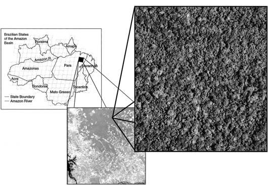
Figure 1. The study area was located in the state of Para, Brazil in the eastern Amazon basin. Landsat 7 image shows location of study site relative to heavy deforestation in the region of Maraba and Paragominas. Panchromatic IKONOS satellite image of study is shown at ca 0.8 m spatial resolution
Data Citation:
Cite this data set as follows:
Asner, G., M. Palace, M. Keller, M. Pereira, J. Silva, and J. Zweede. 2012. LBA-ECO TG-07 Tree Geometry in an Undisturbed Forest in Cauaxi, Para, Brazil. Data set. Available on-line [http://daac.ornl.gov] from Oak Ridge National Laboratory Distributed Active Archive Center, Oak Ridge, Tennessee, U.S.A. http://dx.doi.org/10.3334/ORNLDAAC/1063
Implementation of the LBA Data and Publication Policy by Data Users:
The LBA Data and Publication Policy [http://daac.ornl.gov/LBA/lba_data_policy.html] is in effect for a period of five (5) years from the date of archiving and should be followed by data users who have obtained LBA data sets from the ORNL DAAC. Users who download LBA data in the five years after data have been archived must contact the investigators who collected the data, per provisions 6 and 7 in the Policy.
This data set was archived in February of 2012. Users who download the data between February 2012 and January 2017 must comply with the LBA Data and Publication Policy.
Data users should use the Investigator contact information in this document to communicate with the data provider. Alternatively, the LBA website [http://lba.inpa.gov.br/lba/] in Brazil will have current contact information.
Data users should use the Data Set Citation and other applicable references provided in this document to acknowledge use of the data.
Table of Contents:
- 1 Data Set Overview
- 2 Data Characteristics
- 3 Applications and Derivation
- 4 Quality Assessment
- 5 Acquisition Materials and Methods
- 6 Data Access
- 7 References
1. Data Set Overview:
Project: LBA (Large-Scale Biosphere-Atmosphere Experiment in the Amazon)
Activity: LBA-ECO
LBA Science Component: Carbon Dynamics
Team ID: TG-07 (Keller / de Mello)
The investigator is Keller, Michael . You may contact Palace, Michael William ; Asner, Gregory P. (greg@globalecology.stanford.edu), and Keller, Michael.
LBA Data Set Inventory ID: TG07_DBH_Cauaxi
Canopy height and crown width in an undisturbed eastern Amazon forest (Cauaxi, Para, Brazil) were derived using a hand-held laser range finder. Trees were selected for crown geometry measurements using a stratified sampling scheme based on manual measurements of diameter at breast height (DBH=1.3 m) as the selection criteria. Crown location (understory, dominant, and superdominant) were recorded for all trees.
2. Data Characteristics:
Canopy structure data are provided as a comma-delimited ASCII file: cauxi_dbh_canopy.csv and include the following data columns:
| Column | Column Heading | Units | Description |
|---|---|---|---|
| 1 | Record_ID | Record ID number | |
| 2 | Tree_ID | Tree number in field | |
| 3 | DBH | centimeters | Diameter at breast height (cm) |
| 4 | rnd_num | Random number to determine if height is measured | |
| 5 | ht_toc | meters | Height to top of canopy (m) |
| 6 | ht_boc | meters | Height to bottom of canopy (m) |
| 7 | crown_width | meters | Crown width at greatest diameter (m) |
| 8 | canopy_class | Canopy class (U = understory, D=Dominant, S=SuperDominant) | |
| 9 | notes | Notes | |
| missing values for canopy width are represented as -999; placeholders for missing values for other fields are not included. | |||
Example data records:
| Record_ID,Tree_ID,DBH,rnd_num,ht_toc,ht_boc,crown_width,canopy_class,notes 1,247,39,9,,,,, 2,248,26,7,,,,, 3,249,76,5,,,,, 4,250,20,2,,,,, 5,251,28,3,,,, 6,252,29,8,,,, 7,253,55,2,,,, 8,254,31,9,,,, 9,255,30,0,26.29,20.27,8.7,D 10,256,33,7,,,, 11,257,27,7,,,, 12,258,25,1,22,18.13,7.63,U 13,259,34,8,,,, ... |
Site boundaries: (All latitude and longitude given in degrees and fractions)
| Site (Region) | Westernmost Longitude | Easternmost Longitude | Northernmost Latitude | Southernmost Latitude | Geodetic Datum |
|---|---|---|---|---|---|
| Para Eastern (Belem) - Fazenda Cauaxi (Para Eastern (Belem)) | -48.29060 | -48.29060 | -3.73130 | -3.73130 | World Geodetic System, 1984 (WGS-84) |
Time period:
- The data set covers the
period 2000/06/10 to 2000/06/22.
- IKONOS in November 2000.
Platform/Sensor/Parameters measured include:
- FIELD INVESTIGATION / STEEL MEASURING TAPE / BIOMASS
- FIELD INVESTIGATION / LASER RANGE FINDER / CANOPY CHARACTERISTICS
3. Data Application and Derivation:
This project assessed the value of the field laser and IKONOS satellite data for measuring tree crown dimensions in a lowland tropical forest of the eastern Amazon, Brazil. A detailed field study of tree crown height, diameter, and depth using a handheld laser range finder and stratified sampling criteria based on the tree stem diameter at breast height (DBH) was carried out. Differences in crown shape between different tree size classes were also quantified.
The field-based measurements of crown diameter and area were compared to estimates derived manually from panchromatic 0.8 m spatial resolution IKONOS satellite imagery. Median crown diameter derived from satellite observations was 78 percent greater than that derived from field-based laser measurements. The statistical distribution of crown diameters from IKONOS was biased toward larger trees, probably due to merging of smaller tree crowns, underestimation of understory trees, and overestimation of individual crown dimensions. The median crown area derived from IKONOS was 65 percent higher than the value modeled from field-based measurements. Investigators concluded that manual interpretation of IKONOS satellite data did not accurately estimate distributions of tree crown dimensions in a tall tropical forest of eastern Amazonia.
4. Quality Assessment:
Measurement data quality was good. Discussion of sampling and measurement comparability, representativeness, and accuracy are discussed in Asner et al. (2002).
KNOWN PROBLEMS: Only the general location for this study was identified -- Cauaxi, Para, Brazil. The tree measurement data are of limited use because coordinates for the study site, coordinates of the beginning and end of the transects, and coordinates of the measured trees were not provided. Also, the area that the IKONOS image captured was not provided and the IKONOS image is not available due to restricted distribution.
5. Data Acquisition Materials and Methods:
A forest site of ca 50 ha was selected for field and satellite measurements (Fig. 1). The most common upper canopy species found at the site were Manilkara huberii, Manilkara paraensis, Protium pernevatum, Dinizia excelsa, Piptadenia suaveolens, Licania spp., Astronium lecointei, Eschweilera odorata, and Parkia spp. Stand basal area was ca 57 m2/ha for trees greater than 10 cm DBH.
Line transects of 500 m length were spaced at 50 m intervals crossing the study plot (N = 20). Fourteen of these transects were randomly selected for surveys of DBH, tree height, and crown dimensions. DBH measurements were collected for 2,171 individuals encountered with DBH > 20 cm (measured 1.3 m above ground or above buttresses) within 10 m to either side of each transect. For 300 selected trees, investigators collected additional crown dimension measurements including top-of-crown height, bottom-of crown height, and crown width along the estimated longest axis. Crown depth was estimated as the difference in tree height from the top to bottom of crown. These measurements were collected using a handheld laser range finder (Impulse-200LR, Laser Technology Inc., Englewood, Colorado), which measures distance and calculates heights via an angular measurement simultaneously taken from a clinometer integrated into the instrument.
6. Data Access:
This data is available through the Oak Ridge National Laboratory (ORNL) Distributed Active Archive Center (DAAC).
Data Archive Center:
Contact for Data Center Access Information:
E-mail: uso@daac.ornl.gov
Telephone: +1 (865) 241-3952
7. References:
Asner, G., Palace, M., Keller, M., Pereira, M., Silva, J., and Zweede, J. (2002), Estimating Canopy Structure in an Amazon Forest from Laser Rangefinder and IKONOS Satellite Observations, Biotropica 34(4): 483-492.