Summary:
This data set provides active fire detection images and associated summary information derived from Landsat 7 Enhanced Thematic Mapper Plus (ETM+) images for various locations in Brazilian Amazonia during 2001-2003. There are two image types: (1) GeoTiff images (masks) of active fire pixels, and (2) GeoTiff images (masks) of clustered active fire pixels where a distinct cluster identification number has been assigned to each individual group of contiguous active fire pixels. There are 122 GeoTiff format files of each type of fire mask; a total of 244 images. The spatial resolution of the fire mask images is 30 meters. ETM+ images were selected based on data quality, availability, as well as on the occurrence of vegetation fires.
In addition to the two image types, there are also two types of fire pixel summary information provided in text files: (1) one file of active fire pixel summary information derived from the active fire pixel images, and (2) 122 files of clustered active fire pixel information derived from individual clustered fire pixel masks, each of which correspond to a clustered image.
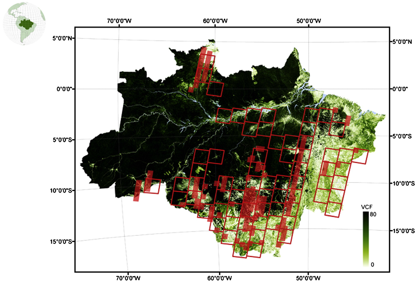
Fig. 1. Locations of Landsat ETM+ (red boxes) scenes used to produce the fire masks, over percent tree cover data (Hansen et al., 2002). Shaded red areas are ASTER scenes from a related study. From Schroeder et al. (2008).
Data Citation:
Cite this data set as follows:
Schroeder, W., E. Prins, L. Giglio, I. Csiszar, C. Schmidt, J. Morisette, and D. Morton. 2012. LBA-ECO LC-35 Landsat ETM+ Derived Active Fire Masks, Brazilian Amazon: 2001-2003. Data set. Available on-line [http:/daac.ornl.gov] from Oak Ridge National Laboratory Distributed Active Archive Center, Oak Ridge, Tennessee, U.S.A. http://dx.doi.org/10.3334/ORNLDAAC/1071
Implementation of the LBA Data and Publication Policy by Data Users:
The LBA Data and Publication Policy [http://daac.ornl.gov/LBA/lba_data_policy.html] is in effect for a period of five (5) years from the date of archiving and should be followed by data users who have obtained LBA data sets from the ORNL DAAC. Users who download LBA data in the five years after data have been archived must contact the investigators who collected the data, per provisions 6 and 7 in the Policy.
This data set was archived in April of 2012. Users who download the data between April 2012 and March 2017 must comply with the LBA Data and Publication Policy.
Data users should use the Investigator contact information in this document to communicate with the data provider. Alternatively, the LBA website [http://lba.inpa.gov.br/lba/] in Brazil will have current contact information.
Data users should use the Data Set Citation and other applicable references provided in this document to acknowledge use of the data.
Table of Contents:
- 1 Data Set Overview
- 2 Data Characteristics
- 3 Applications and Derivation
- 4 Quality Assessment
- 5 Acquisition Materials and Methods
- 6 Data Access
- 7 References
1. Data Set Overview:
Project: LBA (Large-Scale Biosphere-Atmosphere Experiment in the Amazon)
Activity: LBA-ECO
LBA Science Component: Land Use and Land Cover
Team ID: LC-35 (Csiszar / Longo / Setzer)
The investigators were Csiszar, Ivan Andras; Longo, Karla Maria; Brunner, Jason; Freitas, Saulo Ribeiro de; Morisette, Jeffrey Thomas; Prins, Elaine; Schmidt, Christopher C.; Schroeder, Wilfrid and Setzer, Alberto W. You may contact Schroeder, W. (schroeder@hermes.geog.umd.edu).
LBA Data Set Inventory ID: LC35_Landsat7_Fire_Masks
This data set provides active fire detection images and associated summary information derived from Landsat 7 Enhanced Thematic Mapper Plus (ETM+) images for various locations in Brazilian Amazonia during 2001-2003. There are two image types: (1) GeoTiff images (masks) of active fire pixels, and (2) GeoTiff images (masks) of clustered active fire pixels where a distinct cluster identification number has been assigned to each individual group of contiguous active fire pixels. There are 122 GeoTiff format files of each type of fire mask; a total of 244 images. The spatial resolution of the fire mask images is 30 meters. ETM+ images were selected based on data quality and availability, as well as on the occurrence of vegetation fires. In addition to the two image types, there are also two types of fire pixel summary information provided in text files: (1) one file of active fire pixel summary information derived from the active fire pixel images, and (2) 122 files of clustered active fire pixel information derived from individual clustered fire pixel masks, each of which correspond to a clustered image. These files contain the latitude, longitude, and cluster identification number of each clustered active fire pixels in the corresponding image.
Related Data Sets
- LBA-ECO LC-23 ASTER and MODIS Fire Data Comparison for Brazil: 2003-2004
- LBA-ECO LC-23 Characterization of Vegetation Fire Dynamics for Brazil: 2001-2003
- LBA-ECO LC-23 Vegetation Fire Data, Roraima, Brazil: 2003
2. Data Characteristics:
There are 122 GeoTiff format files for each of the fire mask products. File names indicate the year/month/day each image was acquired. The spatial extents of some images will overlap when a site was revisited on different dates. Note that the time of revisit of Landsat7 ETM+ is 16 days; however, the image selection contains only a limited number of locations imaged 16 days apart. There are 122 ASCII files that each correspond to one of the clustered images.
Image file characteristics:
- Resolution: 30 meters
- Projection: Universal Transverse Mercator (UTM). Images are in UTM Zones 19S, 20S, 20N, 21S, 22S, and 23S. The specific zone is given in the GeoTiff file.
- Datum: South American 1969
File naming convention
The files names are coded as follows:
L7_PPPRRR_YYYYMMDD_fire_T*.
L7 = Landsat7 data
PPP = Landsat7 path number
RRR = Landsat7 row number
YYYY = acquisition year
MM= acquisition month
DD = acquisition day
T* = type (mask, clusters, ASCII file (txt))
Examples: L7_232068_20020906_fire_mask.tif; L7_232068_20020906_fire_clusters.tif; L7_232068_20020906_fire.csv
Data files are described as follows:
1) Active Fire Masks: GeoTiff files composed of two values: 0 - no fire activity; 1- active fire. Data type is byte (8 bits). 122 files provided.
2) Clustered Fire Masks: GeoTiff files where pixels without fire activity have been assigned the value ‘0’. Pixels showing fire activity have been assigned a distinct cluster identification number to each group of contiguous pixels. These images are unsigned integer (16 bits). 122 files provided.
3) Active fire pixel detection summary information: This data file lists the total number of active fire pixels identified in each Landsat 7 ETM+ image.
Active_fire_pixel_summary.csv
| Heading | Units/format | Description |
|---|---|---|
| Path | Landsat7 path number | |
| Row | Landsat7 row number | |
| Year | yyyy | acquisition year |
| Month | mm | acquisition month |
| Day | dd | acquisition day |
| Hour | hh | acquisition hour (UTC) |
| Min | mm | acquisition minute (UTC) |
| Active_fire_pixels | number of active fire pixels detected for that image |
Example data records:
|
Path,Row,Year,Month,Day,Hour,Min,Active_fire_pixels 1,67,2002,10,6,14,21,204 220,65,2002,8,17,12,54,2305 221,65,2001,8,5,13,1,2416 221,65,2003,5,23,13,1,419 ... 232,67,2001,9,19,14,9,245 232,67,2002,9,6,14,9,855 232,68,2001,9,19,14,10,156 232,68,2002,9,6,14,9,126 |
4) Clustered active fire pixel information: These files contain the fire detection information derived from each of the clustered fire masks. Files include three columns describing latitude, longitude, and cluster identification number of each active fire pixel in the corresponding image. There are 122 comma-separated ASCII files that each correspond to one of the clustered images. File names follow the convention listed above (e.g., L7_232068_20020906_fire.csv).
| Heading | Units/format | Description |
|---|---|---|
| latitude | Decimal degrees | Latitude of each active fire pixel |
| longitude | Decimal degrees | Longitude of each active fire pixel |
| cluster_id | Cluster identification number of each active fire pixel |
Example data records:
|
latitude,longitude,cluster_id -9.40551, -66.0613, 1 -9.40849, -66.0654, 2 -9.40872, -66.0657, 2 -9.40876, -66.0654, 2 ... -10.6771, -67.7522, 66 -10.6818, -67.7465, 67 -10.6952, -67.7443, 68 -10.9243, -66.1725, 69 |
Site boundaries: (All latitude and longitude given in decimal degrees)
| Site (Region) | Westernmost Longitude | Easternmost Longitude | Northernmost Latitude | Southernmost Latitude | Geodetic Datum |
|---|---|---|---|---|---|
| Brazilian Amazonia (Brazilian Amazonia) | -68 | - 43 | 5 | -18 | World Geodetic System, 1984 (WGS-84) |
Time period:
- The data set covers the period 2001/01/22 to 2003/05/23.
- Temporal Resolution: No better than 16 days
Platform/Sensor/Parameters measured include:
- LANDSAT-7 / ETM+ (ENHANCED THEMATIC MAPPER PLUS) / LAND MANAGEMENT
3. Data Application and Derivation:
This product can be used to identify areas of active fires at 30-m nominal resolution. Active fire pixels are classified as such using a contextual approach based on top of atmosphere reflectance values derived from ETM+ bands 4 and 7. The classification method is described in detail in the work of Schroeder et al. (2008). The Landsat 7 Enhanced Thematic Mapper Plus (ETM+) data served as “ground truth” data to validate the coarser resolution products. See Schroeder et al. (2008).
4. Quality Assessment:
Visual quality assessment of the product was performed for each individual image. Commission errors could not be found. Omission errors may occur in areas of ambiguous fire activity (e.g., smoldering fires). See Schroeder et al. (2008).
5. Data Acquisition Materials and Methods:
The data set is composed of active fire masks derived from Landsat ETM+ images at 30-m nominal resolution. Products were generated from bands 4 and 7 using a contextual fire detection scheme with details given in Schroeder et al. (2008). In this study 122 Landsat ETM+ scenes were available for analysis through the National Institute for Space Research (INPE, Brazil) and the Global Land Cover Facility (GLCF; URL: http://glcf.umiacs.umd.edu/index.shtml). The scenes cover the period from 2000–2003.
Sensors used include:
- ETM+ (ENHANCED THEMATIC MAPPER PLUS)
6. Data Access:
This data is available through the Oak Ridge National Laboratory (ORNL) Distributed Active Archive Center (DAAC).
Data Archive Center:
Contact for Data Center Access Information:
E-mail: uso@daac.ornl.gov
Telephone: +1 (865) 241-3952
7. References:
Schroeder, W., Prins, E., Giglio, L., Csiszar, I., Schmidt, C., Morisette, J., and Morton, D. (2008). Validation of GOES and MODIS active fire detection products using ASTER and ETM+ data. Remote Sensing of Environment, 112, 2711-2726.