Get Data
Summary:
This data set contains forest cover information for 2001 for all of South America. The data were collected by the MODIS sensor onboard the TERRA platform and released by the MODIS team as an image showing percent canopy cover. This information was then reclassified so that all pixels with a percent canopy cover greater than 40% (40% after the 1973 UNESCO standard) were classified as forest (a value of 1), and all other pixels were classified as non-forest (a value of 2). Water features were given a value of 3. This data has a pixel resolution of 500 meters and is unprojected with the WGS-1984 datum (Hansen et al. 2006). There is one GeoTIFF data file for this data set.
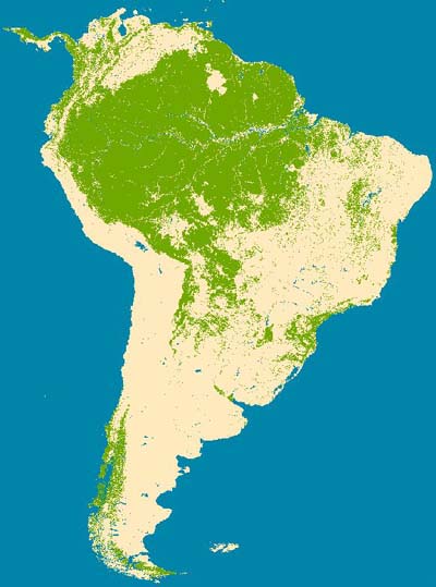
Figure 1. Forest cover at 500 meter resolution of South America in 2001 derived from MODIS imagery.
Data Citation:
Cite this data set as follows:
Walker, R.T. and Jiaguo Qi. 2011. LBA-ECO LC-24 Forest Cover Map from MODIS, 500-m, South America: 2001. Data set. Available on-line [http://daac.ornl.gov] from Oak Ridge National Laboratory Distributed Active Archive Center, Oak Ridge, Tennessee, U.S.A. doi:10.3334/ORNLDAAC/1056
Implementation of the LBA Data and Publication Policy by Data Users:
The LBA Data and Publication Policy [http://daac.ornl.gov/LBA/lba_data_policy.html] is in effect for a period of five (5) years from the date of archiving and should be followed by data users who have obtained LBA data sets from the ORNL DAAC. Users who download LBA data in the five years after data have been archived must contact the investigators who collected the data, per provisions 6 and 7 in the Policy.
This data set was archived in December of 2011. Users who download the data between December 2011 and November 2016 must comply with the LBA Data and Publication Policy.
Data users should use the Investigator contact information in this document to communicate with the data provider. Alternatively, the LBA Web Site [http://lba.inpa.gov.br/lba/] in Brazil will have current contact information.
Data users should use the Data Set Citation and other applicable references provided in this document to acknowledge use of the data.
Table of Contents:
- 1 Data Set Overview
- 2 Data Characteristics
- 3 Applications and Derivation
- 4 Quality Assessment
- 5 Acquisition Materials and Methods
- 6 Data Access
- 7 References
1. Data Set Overview:
Project: LBA (Large-Scale Biosphere-Atmosphere Experiment in the Amazon)
Activity: LBA-ECO
LBA Science Component: Human Dimensions
Team ID: LC-24 (Walker / Reis)
The investigators were Walker, Robert T. and Jiaguo Qi.
LBA Data Set Inventory ID: LC24_MODIS_Forest_Cover_500-m
This data set contains forest cover information for 2001 for all of South America. The data were collected by the MODIS sensor onboard the TERRA platform and released by the MODIS team as an image showing percent canopy cover. This information was then reclassified so that all pixels with a percent canopy cover greater than 40% (40% after the 1973 UNESCO standard) were classified as forest (a value of 1), and all other pixels were classified as non-forest (a value of 2). Water features were given a value of 3. This data has a pixel resolution of 500 meters and is unprojected with the WGS-1984 datum. There is one GeoTIFF data file for this data set.
Related data sets:
- LBA-ECO LC-01 Topographic data from Four ISAs in Northern Ecuador (Topographic data from the same study areas)
- LBA-ECO LC-01 Hydrography, Morphology and Edaphology of the Northern Ecuadorian Amazon (Hydrographic, morphologic and edaphologic features in the Oriente region of northern Ecuador)
- LBA-ECO LC-01 LULC Classifications for the Ecuador Intensive Study Areas: 1986-1999
2. Data Characteristics:
There is one file with this data set: sa_forest2001.zip. When extrapolated, the zip file contains sa_forest2001.tif which is a map image, and sa_forest2001.tfw which contains information regarding the map such as location and scale.
- Spatial resolution is 0.004496603 degrees (500 m).
- The data set has been derived from MODIS VCF (Hansen et al. 2006).
- Data are unprojected with the WGS-1984 datum.
Site boundaries: (All latitude and longitude given in decimal degrees)
| Site (Region) | Westernmost Longitude | Easternmost Longitude | Northernmost Latitude | Southernmost Latitude | Geodetic Datum |
|---|---|---|---|---|---|
| South America (South America) | -86.38424 | -34.2236455 | 13.6921573 | -56.4548511 | World Geodetic System, 1984 (WGS-84) |
Time period:
- The data set covers the period: 2001/01/01 to 2001/12/31
- Temporal Resolution: annual
Platform/Sensor/Parameters measured include:
- TERRA (MORNING EQUATORIAL CROSSING TIME SATELLITE (EOS AM-1)) / MODIS (MODERATE-RESOLUTION IMAGING SPECTRORADIOMETER) / VEGETATION COVER
3. Data Application and Derivation:
The data were used for comparative land cover studies in the Amazon. The data were derived by reclassifying a MODIS image of percent forest cover into forest, non-forest and water classes.
4. Quality Assessment:
Accuracy and uncertainty was not reported for the original product from which the data was derived.
5. Data Acquisition Materials and Methods:
Original MODIS data downloaded from Global Land Cover Facility (GLCF); http://glcf.umiacs.umd.edu/data/treecover/
The data were collected by the MODIS sensor onboard the TERRA platform and released by the MODIS team as an image showing percent canopy cover. This information was then reclassified so that all pixels with a fractional canopy cover greater than 0.40 (40% after the 1973 UNESCO standard) were classified as forest (a value of 1), and all other pixels were classified as non-forest (a value of 2). Water features were given a value of 3. This data has a pixel resolution of 500 meters and is unprojected with the WGS-1984 datum.
6. Data Access:
This data is available through the Oak Ridge National Laboratory (ORNL) Distributed Active Archive Center (DAAC).
Data Archive Center:
Contact for Data Center Access Information:
E-mail: uso@daac.ornl.gov
Telephone: +1 (865) 241-3952
7. References:
Hansen, M., R. DeFries, J.R. Townshend, M. Carroll, C. Dimiceli, and R. Sohlberg (2006), Vegetation Continuous Fields MOD44B, 2001 Percent Tree Cover, Collection 4, University of Maryland, College Park, Maryland, 2001 [ http://www.glcf.umd.edu/data/vcf/ ].
Related Publications
- Simmons, C., E.Y. Arima, S.P. Aldrich, and M.M. Caldas. 2007. Amazon Land Wars in the South of Para. Annals of the Association of American Geographers. 97(3).
- Aldrich, S., R. Walker, E. Arima, M. Caldas, J. Browder, and S. Perz. 2006. Land-Cover and Land-Use Change in the Brazilian Amazon: Smallholders, Ranchers, and Frontier Stratification. Economic Geography 82(3):265-288.