Get Data
Summary:
This data set contains two files with vegetation data for five Amazonian sites: Altamira, Bragantina, Tome-Acu, and Ponta de Pedras, all in the state of Para, and Yapu, Colombia. One file describes vegetation composition and structure (basal area, biomass, species composition) with different land use histories for all five study sites; the second file describes more specific information about individual plant characteristics (family/species names, DBH, stem and total plant height) within each plot.
Data Citation:
Cite this data set as follows:
Brondizio, E.S., M. Batistella, and E.F. Moran. 2009. LBA-ECO LC-09 Vegetation Composition and Structure in the Brazilian Amazon: 1992-1995. Data set. Available on-line [http://daac.ornl.gov] from Oak Ridge National Laboratory Distributed Active Archive Center, Oak Ridge, Tennessee, U.S.A. doi:10.3334/ORNLDAAC/939
Implementation of the LBA Data and Publication Policy by Data Users:
The LBA Data and Publication Policy [http://daac.ornl.gov/LBA/lba_data_policy.html] is in effect for a period of five (5) years from the date of archiving and should be followed by data users who have obtained LBA data sets from the ORNL DAAC. Users who download LBA data in the five years after data have been archived must contact the investigators who collected the data, per provisions 6 and 7 in the Policy.
This data set was archived in August of 2009. Users who download the data between August 2009 and July 2014 must comply with the LBA Data and Publication Policy.
Data users should use the Investigator contact information in this document to communicate with the data provider. Alternatively, the LBA Web Site [http://lbaeco-archive.ornl.gov/] in Brazil will have current contact information.
Data users should use the Data Set Citation and other applicable references provided in this document to acknowledge use of the data.
Table of Contents:
- 1 Data Set Overview
- 2 Data Characteristics
- 3 Applications and Derivation
- 4 Quality Assessment
- 5 Acquisition Materials and Methods
- 6 Data Access
- 7 References
1. Data Set Overview:
Project: LBA (Large-Scale Biosphere-Atmosphere Experiment in the Amazon)
Activity: LBA-ECO
LBA Science Component: Land Use and Land Cover
Team ID: LC-09 (Moran / Batistella)
The investigators were Moran, Emilio Federico; Batistella, Mateus; Adams, Ryan Thomas; Boucek, Bruce William; Brondizio, Eduardo S.; D'Antona, Alvaro; Demming, Kristin Rooke; Fiorini, Stefano; Futemma, Celia Regina Tomiko; Hedin, Lars; Hetrick, Scott S.; Jensen, Ryan R.; Lu, Dengsheng; Ludewigs, Thomas; Mausel, Paul; McGroddy, Megan; Menzies, John Iral; Navarro, Doris Graziela; Ponzoni, Flavio Jorge; Randolph, J.C.; Schmid, Hans Peter E.; Siqueira, Andrea Dalledone; Toniolo, Maria Angelica; Valeriano, Dalton De Morisson; Valladares, Gustavo Souza; VanWey, Leah and Yu, Genong . You may contact Brondizio, Dr Eduardo S. (ebrondiz@indiana.edu)
LBA Data Set Inventory ID: LC09_Vegetation_Composition
This data set contains two files describing vegetation for five Amazonian sites: Altamira, Bragantina, Tome-Acu, and Ponta de Pedras, all in the state of Para, and Yapu, Colombia. One file describes vegetation composition and structure (basal area, biomass, species composition) with different land use histories for all five study sites; the second file describes more specific information about individual plant characteristics (family/species names, DBH, stem and total plant height) within each plot.
-
For additional information, please see the following web sites:
- ACT, Indiana University ( http://www.indiana.edu/~act/ )
- Instituto Nacional de Meteorologia ( http://www.inmet.gov.br/ )
Related Data Set(s):
- LBA-ECO LC-09 Soil Composition and Structure in the Brazilian Amazon: 1992-1995 (Soil data from 4 of the same 5 Amazonian study sites)
- LBA-ECO LC-09 Daily Precipitation for Altamira and Santarem, Para, Brazil: 1961-1998 (Precipitation data from 3 of the 5 Amazonian study sites)
2. Data Characteristics:
File 1: LC09_Vegetation_Composition_Structure.csv. Missing data values are represented as -9999. Data are in a comma-separated ASCII format.
| Column Number | Column Heading | Units/Format | Variable Description |
|---|---|---|---|
| 1 | Sample_year | YYYY | Sampling year (1992, 1993, 1994, 1995) |
| 2 | Latitude | UTM | X coordinates of center of site or site border - UTM, Brazil sites are generally Zone 22S, WGS84, Yapu site is Zone 19S, |
| 3 | Longitude | UTM | Y coordinates of center of site or site border - UTM, Brazil sites are generally Zone 22S, WGS84, Yapu site is Zone 19S |
| 4 | Location | Sampling location name ( Altamira , Bragantina, Ponta de Pedras, Tome-Acu, Yapu) (sites of Acai (Euterpe oleracea) agroforestry are not included for the Ponta de Pedras region; agroforestry sites not included for Tome-Acu) | |
| 5 | Sample_ID | Sample ID: site code + year of inventory, (e.g. A001-92, B001-92, P001-92, T001-02, YA008-95) (soil sampling was also carried out at each site, from 0 to 1 meter at 20 cm intervals) | |
| 6 | LC_type | Land cover type sampled | |
| 7 | LC_age | year | Land cover age (years) |
| 8 | LU_type | Land use type reported (years of use) | |
| 9 | LULC_hist | Land use/land cover history with dates where available | |
| 10 | Man_mec_ag | Agriculture methods (Manual, Mechanized, Mechanized/Manual) | |
| 11 | Num_burn | Number of burnings | |
| 12 | Fert_use | Fertilizer use (no, yes, no/yes) | |
| 13 | Lrg_plot_area | m2 | Large plot area |
| 14 | Med_plot_area | m2 | Medium plot area |
| 15 | Sm_plot_area | m2 | Small plot area |
| 16 | Veg_ba_und | m2/ha | Vegetation basal area (understory) |
| 17 | Veg_ba_ovr | m2/ha | Vegetation basal area (overstory) |
| 18 | Veg_ba_tot | m2/ha | Vegetation basal area (total) |
| 19 | Veg_biom_und | t/ha | Vegetation biomass (understory) |
| 20 | Veg_biom_ovr | t/ha | Vegetation biomass (overstory) |
| 21 | Veg_biom_tot | t/ha | Vegetation biomass (total) |
| 22 | Num_ind_und | n/ha | Number of individual plants (understory) per hectare |
| 23 | Num_ind_ovr | n/ha | Number of individual plants (overstory) per hectare |
| 24 | Veg_ht_avg | m | Vegetation height (average) |
| 25 | Veg_ht_max | m | Vegetation height (maximum) |
| 26 | Num_fam_und | Species composition - number of families (understory) | |
| 27 | Num_fam_ovr | Species composition - number of families (overstory) | |
| 28 | Num_fam_tot | Species composition - number of families (total) | |
| 29 | Num_sp_und | Species composition - number of species (understory) | |
| 30 | Num_sp_ovr | Species composition - number of species (overstory) | |
| 31 | Num_sp_tot | Species composition - number of species (total) |
Example Data Records:
| Header records omitted Column Number,Column Heading,Units/Format,Variable Description 1995,-9999,347822,Yapu,YA005-95,SS,15,Swidden agriculture,Before 1979-forest or old growth; 1979-crop; 1980-fallow ,No data reported,-9999,No data reported,1500,50,-9999,7.3,12.2,19.5,-9999,-9999,-9999,-9999,-9999,11.8,13.6,-9999,-9999,-9999,-9999,-9999,-9999 1995,-9999,346460,Yapu,YA004-95,SS,20,Swidden agriculture,Before 1974-forest or old growth; 1974-crop; 1975-fallow ,No data reported,-9999,No data reported,1500,50,-9999,7.8,10.7,18.5,-9999,-9999,-9999,-9999,-9999,11.42,12.7,-9999,-9999,-9999,-9999,-9999,-9999 ... 1995,-9999,347910,Yapu,YA001-95,Upland forest,-9999,No use reported,No use reported,No data reported,-9999,No data reported,1500,50,-9999,6.4,34.1,40.5,-9999,-9999,-9999,-9999,-9999,16.5,20.9,-9999,-9999,-9999,-9999,-9999,-9999 1995,-9999,348417,Yapu,YA002-95,Sabana Alta,-9999,No use reported,No use reported,No data reported,-9999,No data reported,1500,50,-9999,4.59,15.24,19.75,-9999,-9999,-9999,-9999,-9999,13.3,15.5,-9999,-9999,-9999,-9999,-9999,-9999 1995,-9999,348417,Yapu,YA003-95,Savana Baixa,-9999,No use reported,No use reported,No data reported,-9999,No data reported,1500,50,-9999,0.72,-9999,0.72,-9999,-9999,-9999,-9999,-9999,1.12,2.8,-9999,-9999,-9999,-9999,-9999,-9999 |
File 2: LC09_VegetationSpecies_PlotData.csv. Missing data values are represented as -9999. Data are in a comma-separated ASCII format.
| Column Number | Column Heading | Units/format | Description |
|---|---|---|---|
| 1 | Sample_year | YYYY | Sampling year (1992, 1993, 1994, 1995) |
| 2 | Latitude | UTM | X coordinates of center of site or site border - UTM, Brazil sites are generally Zone 22S, WGS84, Yapu site is Zone 19S |
| 3 | Longitude | UTM | Y coordinates of center of site or site border - UTM, Brazil sites are generally Zone 22S, WGS84, Yapu site is Zone 19S |
| 4 | Location | Sampling location name ( Altamira, Bragantina, Ponta de Pedras, Tome-Acu, Yapu) (sites of Acai (Euterpe oleracea) agroforestry are not included for the Ponta de Pedras region; agroforestry sites not included for Tome-Acu) | |
| 5 | Site_num | Site number | |
| 6 | Plot_num | Plot number | |
| 7 | Subplot_num | Subplot number | /tr>|
| 8 | Plot_area | m2 | Plot area |
| 9 | SS_age | Age of secondary succession (years) | |
| 10 | SS_state | State of secondary succession | |
| 11 | Family | Plant family name | |
| 12 | Species | Plant species name | |
| 13 | Com_name | Plant common name. None, if not provided. | |
| 14 | Num_ind | Number of individuals | |
| 15 | Perc_cov | % | Percent of soil surface covered in vegetation |
| 16 | DBH | cm | Diameter at breast height in centimeters (cm) |
| 17 | Stem_ht | m | Stem height in meters (m) |
| 18 | Tot_ht | m | Total tree height in meters (m) |
| 19 | Broken_tree | yes | Yes, if measured plant was a broken tree. Otherwise, No. |
| 20 | Obs | Additional observations. None, if there are no observations. |
Example Data Records:
| Header records omitted
Sample_year,Latitude,Longitude,Location,Site_num,Plot_num,Subplot_num,Plot_area,SS_age,SS_state,Family,Species,Com_name,Num_ind,Perc_cov, DBH,Stem_ht,Tot_ht,Broken_tree,Obs 1992,9637017,344603,Altamira,1,1,0,2250,16,3,Cecropiaceae,Cecropia (folha fina),None,1,-9999, 27.12,10,18,No,None 1992,9637017,344603,Altamira,1,1,0,2250,16,3,Cecropiaceae,Cecropia (folha fina),None,1,-9999, 32.7,10,18,No,None 1992,9637017,344603,Altamira,1,1,0,2250,16,3,Lauraceae,Nectandra guianensis,None,1,-9999, 12.5,4,6,No,None ... 1995,19-0068933,351892,Yapu,8,10,0,100,3,1,Cecropiaceae,Cecropia sciadophylla,guarumo,6,-9999, -9999,-9999,-9999,No,None 1995,19-0068934,351893,Yapu,8,10,0,100,3,1,-9999,-9999,yabiri (samambaia),30,-9999, -9999,-9999,-9999,No,None 1995,19-0068935,351894,Yapu,8,10,0,100,3,1,Melastomataceae,Miconia sp. 2,tou,51,-9999, -9999,-9999,-9999,No,None |
Site boundaries: (All latitude and longitude given in degrees and fractions)
| Site (Region) | Westernmost Longitude | Easternmost Longitude | Northernmost Latitude | Southernmost Latitude | Geodetic Datum |
|---|---|---|---|---|---|
| Para Eastern (Belem) - Bragantina (Para Eastern (Belem)) | -53.80000 | -53.52000 | -2.50000 | -1.00000 | South-American Datum, 1969 (SAD-69) |
| Para Western (Santarem) - Altamira (Para Western (Santarem)) | -54.00000 | -51.00000 | -2.5.0000 | -4.00000 | South-American Datum, 1969 (SAD-69) |
| Para Eastern (Belem) - Tome Acu (Para Eastern (Belem)) | -48.18000 | -48.18000 | -2.40000 | -2.40000 | South-American Datum, 1969 (SAD-69) |
| Para Eastern (Belem) - Ponta de Pedras (Para Eastern (Belem)) | -48.86000 | -48.86000 | -1.36000 | -1.36000 | South-American Datum, 1969 (SAD-69) |
| Colombia - Yapu (Colombia) | -72.00000 | -69.00000 | -1.50000 | -2.50000 | South-American Datum, 1969 (SAD-69) |
Time period:
- The data set covers the period 1992/01/01 to 1995/12/31
- Temporal Resolution: each site was sampled once
Platform/Sensor/Parameters measured include:
- FIELD SURVEY/STEEL MEASURING TAPE/FOREST COMPOSITION/VEGETATION STRUCTURE
- FIELD SURVEY/HUMAN OBSERVER/LAND COVER
3. Data Application and Derivation:
In conjunction with other studies these data provide the basis to link patterns of regrowth and secondary succession to site characteristics such as soil classification and land use history as well as to remote sensing.
4. Quality Assessment:
Plant characteristics was carried out by experienced botanists in the field and doubtful identifications were checked at the herbarium of EMBRAPA in Belem, Para. Botanical samples were collected from half of all species identified to ensure accuracy of taxonomic identification.
5. Data Acquisition Materials and Methods:
The sampling strategy used was comparable across sites and regions. The same plot and subplot sizes were used at each site and region, allowing cross-comparison and integration at the level of plot, site, and region. See the companion file, LC09_Vegetation_Sampling_Scheme.pdf for more information. Plots (10 x 15m) and subplots (5 x 2m) were randomly distributed, but nested inside each other to account for the detailed inventory of trees (DBH>10cm), saplings (DBH 2-10cm), seedlings (DBH<2 cm), and herbaceous vegetation. In the plots, all the individual trees were identified, and measured for DBH, stem height (height of the first major branch), and total height. In the subplots, all individual saplings were identified and measured for diameter and total height, while all seedlings and herbaceous vegetation were identified and counted.
Above-ground dry biomass was derived from inventory data using allometric equations from the literature. Two different biomass equations were used to differentiate between trees and saplings. Brown et al.(1989) equation was used to estimate tree biomass (DBH>10cm). Another equation from Uhl et al. (1988) was used to estimate sapling biomass (DBH 2-10cm). Brown et al. (1989) equation, selected due to its focus on estimating mature forest biomass, was developed based on a large number of forest inventories from different areas of the tropics, focusing on adult trees and mature stands. Uhl et al. (1988) equation was developed from data collected from different stages of secondary succession sites in eastern Amazonia, derived mainly from sapling data. Uhl's generic species equation was selected due to its applicability to a wide range of species. One representative site of each vegetation type was selected for drawing a vegetation profile. Profile drawings were carried out in transects of 50-100 m. All individuals with DBH>2cm were identified, measured, and represented in the profile. Attention was paid to individual architecture, such as shape of trunk, branch distribution, canopy shape and intersection between different canopies. This vegetation profile was an important source of information about vegetation structure and stratification.
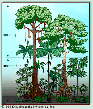
Typical drawing of a forest vegetation profile.
6. Data Access:
This data is available through the Oak Ridge National Laboratory (ORNL) Distributed Active Archive Center (DAAC).
Data Archive Center:
Contact for Data Center Access Information:
E-mail: uso@daac.ornl.gov
Telephone: +1 (865) 241-3952
7. References:
Brown, S., Gillespie, A.J.R., Lugo, A., 1989. Biomass estimation methods for tropical forests with applications to forest inventory data. For. Sci. 35 (4), 881-902.
Uhl, C., Buschbacher, R., Serrao, A.S., 1988. Abandoned pastures in eastern Amazonia. I. Patterns of plant succession. J. Ecol. 76, 663-681.doi:10.2307/2260566