Get Data
Summary:
This data set reports observations of fires in the vicinity of Maraba, Para, Brazil, from November 3-5th, 2001, and in Mato Grosso, Brazil, between Cuiaba and Alta Floresta, for July 12-15th, 2002.
These ground-based data were collected by visual inspection from roads primarily during daylight hours. Data include fire position and time, estimates of fire size, and type of vegetation burned. There is one comma-delimited ASCII file with this data set.
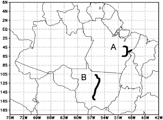
Figure 1. Regions where ground-based fire data were collected: the vicinity of Maraba, in the state of Para, visited from November 3-5, 2001 (region A); between Cuiaba and Alta Floresta, in the state of Mato Grosso, visited from July 12-15, 2002 (region B). Light black lines represent political boundaries. Dark black lines represent tracks driven.
Data Citation:
Cite this data set as follows:
M.F. Cardoso, G.C. Hurtt, B. Moore III, C.A. Nobre and H. Bain. 2012.LBA-ECO LC-08 Passive Ground-based Fire Data, Para and Mato Grosso, Brazil: 2001-2002. Data set. Available on-line [http://daac.ornl.gov] from Oak Ridge National Laboratory Distributed Active Archive Center, Oak Ridge, Tennessee, U.S.A. http://dx.doi.org/10.3334/ORNLDAAC/1095
Implementation of the LBA Data and Publication Policy by Data Users:
The LBA Data and Publication Policy [http://daac.ornl.gov/LBA/lba_data_policy.html] is in effect for a period of five (5) years from the date of archiving and should be followed by data users who have obtained LBA data sets from the ORNL DAAC. Users who download LBA data in the five years after data have been archived must contact the investigators who collected the data, per provisions 6 and 7 in the Policy.
This data set was archived in June of 2012. Users who download the data between June 2012 and May 2017 must comply with the LBA Data and Publication Policy.
Data users should use the Investigator contact information in this document to communicate with the data provider. Alternatively, the LBA website [http://lba.inpa.gov.br/lba/] in Brazil will have current contact information.
Data users should use the Data Set Citation and other applicable references provided in this document to acknowledge use of the data.
Table of Contents:
- 1 Data Set Overview
- 2 Data Characteristics
- 3 Applications and Derivation
- 4 Quality Assessment
- 5 Acquisition Materials and Methods
- 6 Data Access
- 7 References
1. Data Set Overview:
Project: LBA-ECO
Activity: Modeling the Biogeochemical System of the Terrestrial Amazon
LBA Science Component: Land Use and Land Cover
Team ID: LC-08 (Moore / Nobre)
The investigators were Moore, Berrien; Nobre, Carlos Afonso; Braswell, Bobby H.; Cardoso, Manoel Ferreira; Frolking, Steve; Hagen, Steve ; Hurtt, George Caleb; Moorcroft, Paul R.; Pacala, Steve; Palace, Michael William; Peterson, Bruce J.; Tian, Hanqin; Vorosmarty, Charles J.; Wildes, Pam and Xiao, Xiangming. You may contact Cardoso, Manoel (mcardoso@cptec.inpe.br).
LBA Data Set Inventory ID: LC08_Fire_Observations
This data set reports observations of fires in the vicinity of Maraba, Para, Brazil, from November 3-5th, 2001, and in Mato Grosso, Brazil, between Cuiaba and Alta Floresta, for July 12-15th, 2002.
These ground-based data were collected by visual inspection from roads primarily during daylight hours. Data include fire position and time, estimates of fire size, and type of vegetation burned.
2. Data Characteristics:
Data are provided in a single, comma-delimited ASCII file for position and time of fires, estimates of fire size, and type of vegetation burned the study site in Para, Brazil, November 3-5. 2001, and for the site in Mato Grosso, Brazil, July 12-July 15, 2002.
File name: LC08_Ground-Based_Fire_Data_2001-2002.csv
| Column | Variable | Variable Description |
|---|---|---|
| 1 | Fire_ID | Fire identification number |
| 2 | Date | Date (yyyymmdd) |
| 3 | State | State: Para (November 3-4, 2001) or Mato Grosso (July 12-15, 2002) |
| 4 | Time | Time is in GMT (hh:mm) |
| 5 | Obs_Lat | Observation position latitude (decimal degrees) |
| 6 | Obs_Lon | Observation position longitude (decimal degrees) |
| 7 | Event_Lat | Fire event position latitude (decimal degrees) |
| 8 | Event_Lon | Fire event position longitude (decimal degrees) |
| 9 | Size | Fire size class: Size is categorized as small (S, < 0.25 ha), medium (M, 0.25-1 ha), large (L, > 1ha), and unknown (U) |
| 10 | LC | Land cover class: LC is the land cover on which the fire was burning, categorized as pasture = 1, woody savanna = 2, forest = 3, cropland = 4, savanna/grassland = 5, coal production/sawmill = 6, and other = 0 |
Example Data Records:
| ID,Date,State,Time,Obs_Lat,Obs_Lon,Event_Lat,Event_Lon,Size,LC 1,20011103,Para,15:33,-5.335,-49.085,-5.287,-49.132,L,0 2,20011103,Para,15:35,-5.304,-49.072,-5.304,-49.072,S,0 3,20011103,Para,15:35,-5.304,-49.072,-5.336,-49.104,S,0 ... 22,20011104,Para,13:41,-5.300,-49.073,-5.300,-48.782,L,1 23,20011104,Para,14:40,-4,976,-49.076,-4.976,-48.826,U,1 24,20011104,Para,14:50,-4,873,-49.05,-4.873,-49.16,L,0 ... 79,20011105,Para,17:53,-5.529,-49.076,-5.484,-49.087,L,1 80,20011105,Para,18:07,-5.371,-49.078,-5.371,-49.087,L,1 81,20011105,Para,18:36,-5.354,-49.129,-5.354,-49.087,L,1 |
Site boundaries: (All latitude and longitude given in decimal degrees)
| Site (Region) | Westernmost Longitude | Easternmost Longitude | Northernmost Latitude | Southernmost Latitude | Geodetic Datum |
|---|---|---|---|---|---|
| South America including Amazonia (South America including Amazonia) | -56.5 | -55.1 | -9.7 | -15.7 | World Geodetic System, 1984 (WGS-84) |
Time period
- The data set covers the period 2002/07/12 to 2002/07/15
- Temporal Resolution: Continuous
Platform/Sensor/Parameters measured include:
- FIELD INVESTIGATION / HUMAN OBSERVER / FIRE OCCURRENCE
- FIELD INVESTIGATION / HUMAN OBSERVER / FIRE CHARACTERISTICS
3. Data Application and Derivation:
This data set is intended to be used in applications that will enhance the interpretation of satellite-based estimates of fires for environmental studies in Amazonia (Cardoso et. al., 2005).
4. Quality Assessment:
These ground-based fire observations are qualitative in nature.
5. Data Acquisition Materials and Methods:
Site description
We identified two regions in Brazil to collect ground-based data on fire activity. The first is located in the vicinity of Maraba in the state of Para. This region is primarily forest covered and is experiencing rapid deforestation for the formation of pastures and for wood and charcoal production. The second region is located between Cuiaba and Alta Floresta in the state of Mato Grosso. This region can be characterized as a transition zone between savannas and forests with a more diverse set of land-uses and a significant area of croplands (e.g. soy). Both regions are located in or near the Arc of Deforestation (INPE, 2000) and experience high fire activity. These regions were selected for study because of their high fire occurrence, different environments, and ease of access by roads. Specific locations were chosen based on satellite fire pixels maps from previous years and consulting with local researchers. Para was visited from November 3-5, 2001 and Mato Grosso was visited from July 12-15, 2002.
Observations
In each location, data on fire and non-fire occurrence were collected by visual inspection from roads primarily during daylight hours. All areas where we did not observe fires were considered as non-fires. Fire position and time were determined by direct measurement with a handheld Global Positioning System receiver (GARMIN GPS V) or estimated visually from measured positions. Data collected include fire position, time, size, and land-cover. Fire size was estimated in three categories: small (< 0.25 ha), medium (0.25 – 1 ha), and large (> 1 ha). Size combined the area actively burning and the area recently burned. In some cases, fire size could not be estimated because of lack of visibility of the affected area. Land cover included several traditional categories including savanna and grassland, woody savanna, forest, pasture, croplands, charcoal production and sawmills, and for fires that could be specifically classified (‘‘other’’). Field equipment included a car, road maps, a portable GPS receiver, pens, and paper. In total two people participated in Para and three in Mato Grosso.
In some locations, we drove out and back using the same road to enable the estimation of the rate of change in the fire state of the land surface with respect to time. On these repeated tracks, observations of fires could be classified as: fires that were observed only on the way out, fires that were observed only on the way back, and fires that were observed in both directions. Observations of points that were not burning (non-fires) were classified in a similar way: non-fires that were observed only on the way out, non-fires that were observed only on the way back, and non-fires that were observed in both directions.
Of those fires observed, 144 were observed once and 9 were observed twice; 47 (29%) were classified as small; 35 (22%) were medium; 57 (35%) were large; and 23 (14%) did not have their size estimated. There were 86 fires (53%) estimated to be at distances equal to or greater than 1 km from roads. The remaining were estimated to be closer than 1 km. There were 44 fires (27%) observed in forests. woody savannas and savannas or grasslands. There were 64 fires (40%) in pastures,croplands, and around charcoal productions or sawmills. There were 54 (33%) not specifically classified.
6. Data Access:
This data is available through the Oak Ridge National Laboratory (ORNL) Distributed Active Archive Center (DAAC).
Data Archive Center:
Contact for Data Center Access Information:
E-mail: uso@daac.ornl.gov
Telephone: +1 (865) 241-3952
7. References:
Cardoso MF, Hurtt GC, Moore B, Nobre CA, Bain H (2005) Field work and statistical analyses for enhanced interpretation of satellite fire data. Remote Sensing of Environment, 96, 212–227.
INPE. (2000). Monitoring the Brazilian Amazon forest by satellite: 1999–2000. Amazon Institutional Program, General Coordination of Earth Observation. Brazil’ National Institute of Space Research.