Get Data
Revision date: May 5, 2012
Summary:
This data set contains Landsat TM imagery for the years 1986, 1989, 1996, and 1999, that have been classified into four land use/land cover (LULC) classes: Forest, Non-Forest Vegetation, Urban/Barren, and Water; and a fifth class of Clouds/Shadows. The areas of interest were the four Intensive Study Areas (ISA) of the University of North Carolina's Carolina Population Center (CPC) Ecuador Projects: Eastern Intensive Study Area; Northern Intensive Study Area; Southern Intensive Study Area, and Southwestern Intensive Study Area. These areas are in the Northern Ecuadorian Amazon, in the area known as the northern Oriente of Ecuador. The resolution of the data is 30 meters. There are 12 image files (.tif) with this data set.
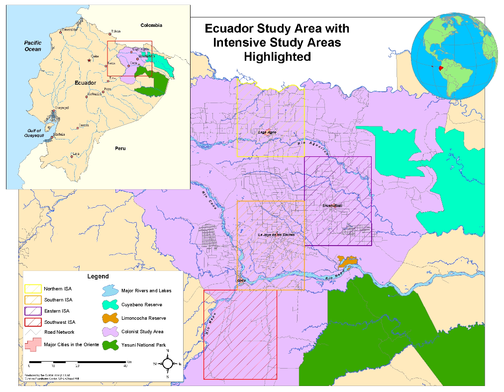
Figure 1. Map of Study Area with Intensive Study Areas Highlighted. Source: Carolina Population Center (CPC), University of North Carolina at Chapel Hill(http://www.cpc.unc.edu/projects/ecuador/maps.html).
Data Citation:
Cite this data set as follows:
Bilsborrow, R.E., S.J. Walsh, and B.G. Frizelle. LBA-ECO LC-01 Landsat TM Land Use/Land Cover, Northern Ecuadorian Amazon: 1986-1999. 2012. Data set. Available on-line [http://daac.ornl.gov] from Oak Ridge National Laboratory Distributed Active Archive Center, Oak Ridge, Tennessee, U.S.A. http://dx.doi.org/10.3334/ORNLDAAC/1084
Implementation of the LBA Data and Publication Policy by Data Users:
The LBA Data and Publication Policy [http://daac.ornl.gov/LBA/lba_data_policy.html] is in effect for a period of five (5) years from the date of archiving and should be followed by data users who have obtained LBA data sets from the ORNL DAAC. Users who download LBA data in the five years after data have been archived must contact the investigators who collected the data, per provisions 6 and 7 in the Policy.
This data set was archived in May of 2012. Users who download the data between May 2012 and April 2017 must comply with the LBA Data and Publication Policy.
Data users should use the Investigator contact information in this document to communicate with the data provider. Alternatively, the LBA website [http://lba.inpa.gov.br/lba/] in Brazil will have current contact information.
Data users should use the Data Set Citation and other applicable references provided in this document to acknowledge use of the data.
Table of Contents:
- 1 Data Set Overview
- 2 Data Characteristics
- 3 Applications and Derivation
- 4 Quality Assessment
- 5 Acquisition Materials and Methods
- 6 Data Access
- 7 References
1. Data Set Overview:
Project: LBA (Large-Scale Biosphere-Atmosphere Experiment in the Amazon)
Activity: LBA-ECO
LBA Science Component: Human Dimensions
Team ID: LC-01 (Bilsborrow / Walsh / Garcia)
The investigators were Bilsborrow, Richard E. and Walsh, Stephen J. You may contact Bilsborrow, Richard E. (richard_bilsborrow@unc.edu); Walsh, Stephen J. (swalsh@email.unc.edu) and Frizzelle, Brian (bgf@email.unc.edu).
LBA Data Set Inventory ID: LC01_LULC_Classes_Ecuador_ISA
This data set contains Landsat imagery that defines four general land use/land cover (LULC) classes as well as Clouds/Shadows: Forest, Non-Forest Vegetation, Urban/Barren, and Water. The classification was for the Intensive Study Areas (ISAs) of the CPC Ecuador Projects, in the northern Oriente of Ecuador. The resolution of the data is 30 meters.
Related data sets (data from studies conducted in same region):
- LBA-ECO LC-01 City, Community, and Road Maps, Northern Ecuadorian Amazon: 1990-2002
- LBA-ECO LC-01 Hydrography, Morphology, Edaphology Maps, Northern Ecuadorian Amazon
- LBA-ECO LC-01 National, Provincial, and Park Boundaries, Ecuador
- LBA-ECO LC-01 Northern Ecuadorian Amazon Household Surveys, Summary Results: 1999
- LBA-ECO LC-01 SRTM 90-Meter Digital Elevation Model, Northern Ecuadorian Amazon
- LBA-ECO LC-01 Topographic Data for Intensive Study Areas, Northern Ecuadorian Amazon
2. Data Characteristics:
There are 12 image files (.tif) with this data set. The file names reflect the years 1986-1999 and the four study areas:
eisa= Eastern Intensive Study Area; nisa= Northern Intensive Study Area; sisa= Southern Intensive Study Area, and swisa= Southwestern Intensive Study Area.
File names:
class86_eisa.tif
class96_eisa.tif
class99_eisa.tif
class86_nisa.tif
class89_nisa.tif
class96_nisa.tif
class99_nisa.tif
class86_sisa.tif
class96_sisa.tif
class99_sisa.tif
class96_swisa.tif
class99_swisa.tif
Spatial Resolution: 30 m
Projection: Universal Transverse Mercator, Zone 18S
Parameters/Variables: ObjectID: Internal feature number; sequential unique whole numbers defined and automatically
generated by ESRI software.
Value: LULC class: 0=No Data,
1=Forest,
2=Non-Forest Vegetation,
3=Urban/Barren,
4=Water,
5=Clouds/Shadows
Count: Number of pixels in the class
Site boundaries: (All latitude and longitude given in decimal degrees)
| Site (Region) | Westernmost Longitude | Easternmost Longitude | Northernmost Latitude | Southernmost Latitude | Geodetic Datum |
|---|---|---|---|---|---|
| Northern Ecuadorian Amazon- Eastern ISA (Ecuador) | -76.752607 | -76.50167 | -0.003319 | -0.33694 | World Geodetic System, 1984 (WGS-84) |
| Northern Ecuadorian Amazon- Northern ISA (Ecuador) | -77.001945 | -76.751846 | 0.288862 | -0.003319 | World Geodetic System, 1984 (WGS-84) |
| Northern Ecuadorian Amazon- Southern ISA (Ecuador) | -77.002551 | -76.75194 | -0.16972 | -0.50389 | World Geodetic System, 1984 (WGS-84) |
| Northern Ecuadorian Amazon- Southwestern ISA (Ecuador) | -77.127167 | -76.855167 | -0.503414 | -0.804885 | World Geodetic System, 1984 (WGS-84) |
Time period:
- The data set covers the period: 1986/08/23 to 1999/11/15
-
Temporal Resolution:
- 1986 (19860823): EISA, NISA, SISA
- 1989 (19890807): NISA
- 1996 (19961021): EISA, NISA, SISA, SWISA
- 1999 (19991115): EISA, NISA, SISA, SWISA
Platform/Sensor/Parameters measured include:
- LANDSAT (LAND REMOTE-SENSING SATELLITE) / ANALYSIS / LAND CLASSES
3. Data Application and Derivation:
Population-environment interaction research requires accurate LULC data for a variety of time periods. This data
was used to determine the spatial structure and pattern of land use in the ISAs.
4. Quality Assessment:
Data Usage Guidance: There are no use constraints. It is
important, however, that potential users be aware that the LULC classes
contained in this data set are general.
Attribute Accuracy Report: Attribution of the pixels is based
on a combination of the classification algorithm and informed
decision-making by the analysts. Accuracy of the classification has not
been determined.
Horizontal Positional Accuracy: Horizontal accuracy is within
0.5 pixels of the true location. Therefore, the accuracy is +/- 15
meters.
5. Data Acquisition Materials and Methods:
Site description:
The Intensive
Study Area (ISA) in northeastern Ecuador portion of
the Amazon Basin measures approximately 90,000 ha in size and is
spatially and functionally linked to the regional capital and largest
central place within the Oriente, Lago Agrio (Messina and Walsh, 2001).
The northeastern Ecuadorian Amazon is significant from social,
biophysical, and geographical bases, with complex terrain and LULC
variability. Settlers in the Napo and Sucumbios provinces, the two
dominant Cantons or States, settled on 50 ha plots, clearing primary
forest to grow subsistence crops, coffee, and for pasturage.
The
western Amazon region, bordering the Andes and lying at the headwaters
of the Amazon River basin, possesses several major centers of endemism,
including the Napo. The annual precipitation is high (2,800 mm/year),
so there is no distinct dry season. Despite the regions global
biodiversity and carbon sequestration significance, agricultural
settlement and concurrent deforestation threaten the region.
Study areas:
The four
intensive study areas in the northern Ecuadorian Amazon included the
Northern Intensive Study Area (NISA), which includes the area around
Lago Agrio; the Southern Intensive Study Area (SISA), which includes
the area around La Joya de los Sachas (between Coca and Shushufindi);
the Eastern Intensive Study Area (EISA), which includes the area around
Shushufindi; and the Southwestern Intensive Study Area (SWISA), which
includes the area around Coca. See Figure 1.
Landsat Images:
Landsat Satellite (Landsat TM) images were acquired from the Earth Resources Observation and Science (EROS) Center. A 255-cluster ISODATA unsupervised classification was performed on the Landsat TM images. Using Transformed Divergence and a minimum divergence of 1950, the 255 clusters were iteratively reduced to 30-40 spectrally separable clusters. The resultant 30-40 spectrally seperable clusters were entered into a maximum-likelihood supervised classification as training data.
The CLUMP and ELIMINATE processes in Imagine (image mapping and visualization software package with grid-based map analysis tools) were applied to the supervised classification output to reduce noise in the image. The Clumping algorithm in Imagine identifies the character of the neighbors around each pixel. For example, pixel 500x-500y is forest, 2 neighbors are forest, 4 are water, 1 is urban, and 1 is fallow. The Eliminate algorithm removes speckle pixels, those random urban pixels in the middle of a forest (Messina et al., 2000). Classes were assigned to the 30-40 cluster supervised output using ancillary data and expert knowledge of the field site. Clusters belonging to the same class were then recoded to that class number.
6. Data Access:
This data is available through the Oak Ridge National Laboratory (ORNL) Distributed Active Archive Center (DAAC).
Data Archive Center:
Contact for Data Center Access Information:
E-mail: uso@daac.ornl.gov
Telephone: +1 (865) 241-3952
7. References:
Messina, J.P. and S.J. Walsh. 2001. 2.5D Morphogenesis: Modeling Landuse and Landcover Dynamics in the Ecuadorian Amazon. Plant Ecology, 156 (1): 75-88.
Messina, J. P., Crews-Meyer, K. A. & Walsh, S. J. 2000. Scale dependent pattern metrics and panel data analysis as applied in a multiphase hybrid landcover classification scheme. Proc. 2000 ASPRS Conf.
Related Publications
- Pan, W.K.Y., Walsh, S.J., Bilsborrow, R.E., Frizzelle, B.G., Erlien, C.M., & Baquero, F. (2004) Farm-level models of spatial patterns of land use and land cover dynamics in the Ecuadorian Amazon. Agriculture, Ecosystems and Environment, 101, 117-134.