Get Data
Revision date: January 26, 2012
Summary:
This data set provides map images of hydrographic, morphologic, and edaphic features for the northern Amazon Basin in eastern Ecuador. The hydrographic data are available at two scales based on the 1:50,000 and 1:250,000-scale topographic source maps that were generated in 1990 and 1993, respectively. Morphological and edaphological data were digitized from a 1:500,000 map published in 1983. There are 3
compressed (*.zip) data files with this data set.
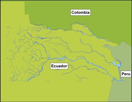
Figure 1. Hydrographic data digitized from 1:50,000 scale topographic map published in 1990.
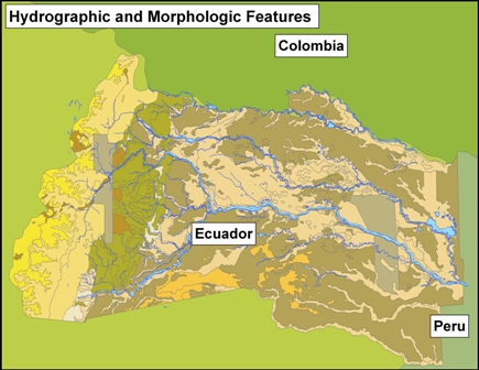
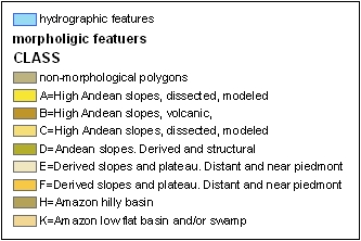
Figure 2. Morphological and edaphological data digitized from a 1:500,000 scale map produced in 1983.
Data Citation:
Cite this data set as follows:
Walsh, S.J., R.E. Bilsborrow and B.G. Frizzelle. 2012. LBA-ECO LC-01 Hydrography, Morphology, Edaphology Maps, Northern Ecuadorian Amazon. Data set. Available on-line [http://daac.ornl.gov] from Oak Ridge National Laboratory Distributed Active Archive Center, Oak Ridge, Tennessee, U.S.A. http://dx.doi.org/10.3334/ORNLDAAC/1059
Implementation of the LBA Data and Publication Policy by Data Users:
The LBA Data and Publication Policy [http://daac.ornl.gov/LBA/lba_data_policy.html] is in effect for a period of five (5) years from the date of archiving and should be followed by data users who have obtained LBA data sets from the ORNL DAAC. Users who download LBA data in the five years after data have been archived must contact the investigators who collected the data, per provisions 6 and 7 in the Policy.
This data set was archived in January of 2012. Users who download the data between January 2012 and December 2016 must comply with the LBA Data and Publication Policy.
Data users should use the investigator contact information in this document to communicate with the data provider. Alternatively, the LBA Web Site [http://lba.inpa.gov.br/lba/] in Brazil will have current contact information.
Data users should use the Data Set Citation and other applicable references provided in this document to acknowledge use of the data.
Table of Contents:
- 1 Data Set Overview
- 2 Data Characteristics
- 3 Applications and Derivation
- 4 Quality Assessment
- 5 Acquisition Materials and Methods
- 6 Data Access
- 7 References
1. Data Set Overview:
Project: LBA (Large-Scale Biosphere-Atmosphere Experiment in the Amazon)
Activity: LBA-ECO
LBA Science Component: Land Surface Hydrology
Team ID: LC-01 (Bilsborrow / Walsh / Garcia)
The investigators were Bilsborrow, Richard E. and Walsh, Stephen J. You may contact Walsh, Stephen J. (swalsh@email.unc.edu); Bilsborrow, Richard E. (richard_bilsborrow@unc.edu) and Frizzelle, Brian G. (bgf@email.unc.edu).
LBA Data Set Inventory ID: LC01_Hydrography_Edaphology_NEC
This data set includes hydrographic, morphologic and edaphologic features in the northern Ecuadorian Amazon. The hydrography is available at two scales based on 1:50,000 and 1:250,000-scale topographic maps.
Related Data Sets:
- LBA-ECO LC-01 Topographic Data for Intensive Study Areas, Northern Ecuadorian Amazon (Topographic data from the 4 intensive study areas located in the northern Ecuadorian Amazon region)
- LBA-ECO LC-01 City, Community, and Road Maps, Northern Ecuadorian Amazon: 1990-2002
- LBA-ECO LC-01 National, Provincial, and Park Boundaries, Ecuador
2. Data Characteristics:
There are three data files in this data set provided as compressed *.zip files. These are zipped ESRI ArcGIS shapefiles. When unzipped, each shapefile contains seven files (.dbf, .prj, .sbn, .sbx, .shp, .shp.xml, .shx.). Each shapefile contains polygon geometry with the following projection parameters:
- Projected Coordinate System: WGS_1984_UTM_Zone_18S
- Projection: Transverse_Mercator
- False_Easting: 500000.000000
- False_Northing: 10000000.000000
- Central_Meridian: -75.000000
- Scale_Factor: 0.999600
- Latitude_of_Origin: 0.000000
- Linear_Unit: Meter
- Geographic Coordinate System: GCS_WGS_1984
- Datum: D_WGS_1984
- Prime Meridian: Greenwich
- Angular Unit: Degree
hy_oriente.zip: morphologic and edaphologic features
Hydrographic 1:50,000 scale
hy_oriente_polygon.xxx: where file extension is .dbf, .prj, .sbn, .sbx, .shp, .shp, .xml, or .shx; hydrographic coverage at the 1:50,000 Scale.
Attributes
- FID: Internal feature number; sequential unique whole numbers that are automatically generated.
- Shape: Feature geometry.
- AREA: Area of feature in internal units squared
- PERIMETER: Perimeter of feature in internal units
- HY_ORIENTE: Internal feature number; sequential unique whole numbers that are automatically generated.
- HY_ORIEN_1: User-defined feature number; sequential unique whole numbers that are automatically generated.
- HYDRO: Hydrography type. 1=Feature is hydrographic
- TYPE: Type of hydrographic feature, 1=Not a hydrographic feature. 10=Stream/river, 20=Major river, 30=Lake, 99= Not a hydrographic feature
- DESCRIP: Description of the code listed in the ‘TYPE’ field
hy_profors.zip: hydrographic features
Hydrographic 1:250,000 scale:
hy_profors_polygon.xxx: where file extension is .dbf, .prj, .sbn, .sbx, .shp, .shp, .xml, or .shx; hydrographic coverage at the 1:250,000 scale.
Attributes
- FID: Internal feature number; sequential unique whole numbers that are automatically generated
- Shape: Feature geometry.
- AREA: Area of feature in internal units squared.
- PERIMETER: Perimeter of feature in internal units
- HY_PROFORS: Internal feature number; sequential unique whole numbers that are automatically generated.
- HYDRO: Hydrography type. 0=Non-hydro, 1=Hydrographic feature.
- TYPE: Type of hydrographic feature. 0=Not a hydrographic feature, 10=Stream/river, 20=Lake, 21=Seasonal lake, 30=Wetland, 40=Intermittent stream, 99= Not a hydrographic feature.
morfo.zip: morphologic and edaphologic features
Morphology
morfo_polygon.xxx: where file extension is .dbf, .prj, .sbn, .sbx, .shp, .shp, .xml, or .shx; morphologic and edaphologic features.
Attributes
- FID: Internal feature number; sequential unique whole numbers that are automatically generated.
- Shape: Feature geometry.
- AREA: Area of feature in internal units squared.
- PERIMETER: Perimeter of feature in internal units.
- MORPHO_ Internal feature number; Sequential unique whole numbers that are automatically generated.
- MORPHO_ID: User-defined feature number.
- CLASS: A=High Andean slopes, dissected, modeled; B=High Andean slopes, volcanic, modeled; C=High Andean slopes, dissected, modeled; D=Andean slopes. Derived and structural slopes; E=Derived slopes and plateau. Distant and near piedmont; F=Derived slopes and plateau. Distant and near piedmont; H=Amazon hilly basin; K=Amazon low flat basin and/or swamp.
- UNIT: Include Classes A through K with subclasses within each indicated by numbers. A detailed description of each unit class is included as a text file in the supporting documentation. Polygons which do not have attributes for CLASS or UNIT are non-morphological polygons (e.g. lakes and rivers).
Site boundaries: (All latitude and longitude given in decimal degrees)
| Site (Region) | Westernmost Longitude | Easternmost Longitude | Northernmost Latitude | Southernmost Latitude | Geodetic Datum |
|---|---|---|---|---|---|
| Northern Ecuadorian Amazon (Ecuador) | -78.000934 | -75.161179 | 0.590914 | -1.177936 | World Geodetic System, 1984 (WGS-84) |
Time period:
- The data set covers the period: 1983/01/01 to 1993/12/31
- Temporal Resolution: not applicable. Maps generated from data published in 1983, 1990, and 1993.
Platform/Sensor/Parameters measured include:
- TOPOGRAPHIC MAP / DIGITIZER / RIVERS/STREAMS
3. Data Application and Derivation:
This data set may be used to gain greater understanding of the northern Ecuadorian Amazon or to inform other analyses (e.g., examining areas of richer soils for differences in LULC and LULC changes) and for cartographic representation in larger-scale maps of the hydrographic network in the Oriente.
Derivation techniques:
All data were digitized from a variety of paper maps. Morphological and edaphological data were digitized from 1:500,000 paper map. Attribution occurred during digitization. 1:50,000-scale topographic maps were digitized.
The hydrographic features on the 1:250,000-scale PROFORS map were digitized. An RMSE of less than 0.01 was achieved in the digitization.
4. Quality Assessment:
Data usage guidance:
- For the morphological and edaphological data it should be noted that the polygons cover broad regions, and as such should not be used for fine-scale analyses.
- For the hydrographic data potential users should be wary of using this data for analyses at scales larger than the originals. Users should also keep in mind that these data do not represent all water bodies in the region.
Positional accuracy:
- 1:250,000 scale hydrographic data: The data set was digitized with less than a 0.01 RMSE. It is assumed that the topographic maps are compliant with the US National Map Accuracy Standards, giving the hydro features no more than a 125 m horizontal error.
- 1:50,000 scale hydrographic data: Horizontal accuracy is considered to be at least as accurate as what can be expected from NMAS standards on a 1:50,000-scale map (~25 m). Morphological and edaphological data: Horizontal accuracy is assumed to be within the NMAS standards for a map of this scale.
5. Data Acquisition Materials and Methods:
Site description
The northern Ecuadorian Amazon is significant from social, biophysical, and geographical bases,
with complex terrain and land-use variability. Settlers in the Napo and Sucumbios provinces, the two dominant Cantons or States, settled on 50
ha plots, clearing primary forest to grow subsistence crops, coffee, and for pasturage. The western Amazon region, bordering the Andes and lying at the headwaters of the Amazon River basin, possesses several major centers of endemism, including the Napo. Despite the regions global biodiversity and carbon sequestration significance, agricultural settlement and concurrent deforestation threaten the region.
A comprehensive description of the Oriente can be found in Messina and Walsh (2001).
Data acquisition
Hydrographic Data
- 1:50,000 scale topographic maps published in 1990. These maps were obtained from the Instituto Geografico Militar de Ecuador (IGM).
- 1:250,000 scale map entitled Mapa del Nororiente de Ecuador: Situacion Legal de las Tierras (scale=1:250,000) produced by Ecuadorian-German project PROFORS (Programa Forestal Sucumbios) and published by INEFAN - PROFORS in 1993 (INEFAN=(Instituto Ecuatoriano Forestal y de Areas Naturales y Vida Silvestre) provided by the Instituto Geografico Militar de Ecuador (IGM).
Morphological and Edaphological Data
- The morphological and edaphological data were digitized from a 1:500,000 scale map entitled Mapa Morfo Edafologico, produced in 1983 by PRONAREG, Ministerio de Agricultura y Ganaderia, Ecuador.
6. Data Access:
This data is available through the Oak Ridge National Laboratory (ORNL) Distributed Active Archive Center (DAAC).
Data Archive Center:
Contact for Data Center Access Information:
E-mail: uso@daac.ornl.gov
Telephone: +1 (865) 241-3952
7. References:
Messina, J.P. and S.J. Walsh. 2001. 2.5D Morphogenesis: Modeling Landuse and Landcover Dynamics in the Ecuadorian Amazon. Plant Ecology 156 (1): 75-88.
Related Publications
- Pan, W.K.Y., Walsh, S.J., Bilsborrow, R.E., Frizzelle, B.G., Erlien, C.M., & Baquero, F. (2004) Farm-level models of spatial patterns of land use and land cover dynamics in the Ecuadorian Amazon. Agriculture, Ecosystems and Environment, 101, 117-134.