Get Data
Summary:
This data set contains physical, hydrologic, political, demographic, and societal maps for the Ji-Parana River Basin, in the state of Rondonia, Brazil. These data were used as base information in subsequent investigations of land use/land cover, biogeochemistry, soils, and water balance processes (Ballester et al., 2003).
This data set includes a Digital Elevation Model (DEM), river networks and morphometric characteristics of the region (derived from the DEM), and a number of social and demographic vector sets (roads as of 2001, county borders, population change from 1970-2000, and settlement projects). The DEM is provided in GeoTIFF format. Other files are provided as shapefiles.
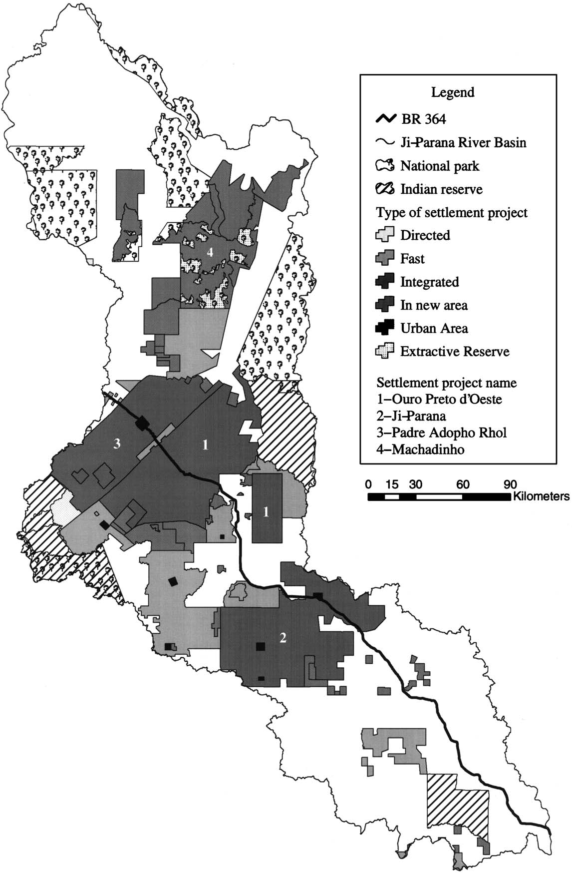
Figure 1. Settlement Projects, Indian reserves and national parks location in the Ji-Parana River Basin (Ballester et al., 2003).
Data Citation:
Cite this data set as follows:
Ballester, M.V.R. 2012. LBA-ECO CD-06 Physical, Political, and Hydrologic Maps, Ji-Parana River Basin, Brazil. Data set. Available on-line [http://daac.ornl.gov] from Oak Ridge National Laboratory Distributed Active Archive Center, Oak Ridge, Tennessee, U.S.A. http://dx.doi.org/10.3334/ORNLDAAC/1090
Implementation of the LBA Data and Publication Policy by Data Users:
The LBA Data and Publication Policy [http://daac.ornl.gov/LBA/lba_data_policy.html] is in effect for a period of five (5) years from the date of archiving and should be followed by data users who have obtained LBA data sets from the ORNL DAAC. Users who download LBA data in the five years after data have been archived must contact the investigators who collected the data, per provisions 6 and 7 in the Policy.
This data set was archived in June of 2012. Users who download the data between June 2012 and May 2017 must comply with the LBA Data and Publication Policy.
Data users should use the Investigator contact information in this document to communicate with the data provider. Alternatively, the LBA website [http://lba.inpa.gov.br/lba/] in Brazil will have current contact information.
Data users should use the Data Set Citation and other applicable references provided in this document to acknowledge use of the data.
Table of Contents:
- 1 Data Set Overview
- 2 Data Characteristics
- 3 Applications and Derivation
- 4 Quality Assessment
- 5 Acquisition Materials and Methods
- 6 Data Access
- 7 References
1. Data Set Overview:
Project: LBA (Large-Scale Biosphere-Atmosphere Experiment in the Amazon)
Activity: LBA-ECO
LBA Science Component: Land Surface Hydrology
Team ID: CD-06 (Richey / Victoria)
The investigators were Richey, Jeffrey E.; Victoria, Reynaldo Luiz; Souza, Reginaldo Felix; Aalto, Rolf Erhart; Abdo, Mara Silvia Aguiar; Alin, Simone Rebecca; Aufdenkampe, Anthony K.; Ballester, Maria Victoria Ramos; Barbosa, Roosevelt Passos; Bernardes, Marcelo Correa; Bezerra de Barros Lima, Roberta; Bolson, Marcos Alexandre; Bonelle, Nilton; Brito, David Silva; Cabianchi, Giovana Mendonca; Cogo, Michelle Cristine; Cunha, Hillandia Brandao; Silva, Luis Vilmar Souza da; Dalmagro, Higo Jose; Deus, Fabiano Alves de; Devol, Allan H.; Nascimento, Clive Reis do; Ellis, Erin Elizabeth; Ferro, Jaderson Coradi; Filho, Walter Jorge do Nascimento; Frickmann, Fernando Cruz; Guandique, Manuel Enrique Gamero; Gomes, Beatriz M.; Gomes, Viviane; Neto, Sergio Candido Gouveia; Hanada, Lais de Carvalho; Holtgrieve, Gordon William; Silva, Roberta Kelly Batalha; Krusche, Alex V.; Kurzatkowski, Dariusz; Lacerda, Francisco A. Siebra; Leite, Nei Kavaguichi; Logsdon, Miles Grant; Macedo, Gelson de; Marcondes, Renata; Marilheuza, Campos Paro; McGeoch, Lauren; Melo, Emanuele Gurgel de Freitas; Mendes, Francisco de Assis; Moreira, Marcelo Zacharias; Munhoz, Kelli Cristina Aparecida; Neu, Vania; Oliveira, Carolina Barisson Marques; Ometto, Jean Pierre H.B.; Pimentel, Tania Pena; Filho, Nicolau Priante; Rabelo, Claudenir Silva; Rasera, Maria de Fatima Fernandes Lamy; Remington, Sonya Marie; Rodda, Sarah; Ruiz Mateus, Neuza Maria; Salimon, Cleber Ibraim; Santiago, Alailson Venceslau; Santos, Arnoldo Marcilio dos; Silva, Cleoni Virginio da; Silva, Jonismar Souza; Silva, Simao Correa da; Sousa, Eliete dos Santos; Souzapetro, Petronio Lopes de; Toledo, Andre Marcondes Andrade; Tumang, Cristiane Azevedo; Umetsu, Cristiane Akemi; Victoria, Daniel de Castro and Xavier, Farley de Oliveira . You may contact Ballester, Maria Victoria Ramos (vicky@cena.usp.br).
LBA Data Set Inventory ID:
This dataset contains physical, hydrologic, political, demographic, and social map for the Ji-Parana River Basin, in the state of Rondonia, Brazil. These data were used as base information in subsequent investigations of land use/land cover, biogeochemistry, soils, and water balance processes (Ballester et al., 2003).
Related data sets:
- LBA-ECO CD-06 Biogeochemistry of Ji-Parana River and Tributaries, Brazil: 1999-2001 (Physical template data were used as base layers in Ji-Parana biogeochemistry analysis.)
- LBA-ECO CD-06 Ji-Parana River Basin Land Use and Land Cover Map, Brazil, 1999 (Physical template data were used as base layers in Ji-Parana land use/land cover analysis.)
- LBA-ECO CD-06 Land Use/Land Cover Time Series for Ji-Parana Basin, Brazil: 1986-2001 (Physical template data were used as base layers in Ji-Parana land use/land cover time-series analysis.)
- LBA-ECO CD-06 Soil Texture and Cation Content for Ji-Parana Basin Soils, Brazil, 1998 (Physical template data were used as base layers in Ji-Parana soils analysis.)
2. Data Characteristics:
There are seven data files provided with this dataset. The Digital Elevation Model data are in GeoTIFF format. There six compressed (*.zip) ESRI ArcGIS shapefiles. When unzipped, each shapefile contains seven files (.dbf, .prj, .sbn, .sbx, .shp, .xml, .shx).
The following GeoTIFF is provided with this dataset:
dem.tif a Digital Elevation Model of the Ji-Parana River Basin.
Image file characteristics:
- Resolution: 100 meters
- Projection: WGS_84_UTM_zone_20S
- Datum: D_WGS_1984
The six ESRI ArcGIS shapefiles provided with this dataset have the following projection parameters:
- Projection: WGS_1984_UTM_Zone_20S
- False_Easting: 500000.000000
- False_Northing: 10000000.000000
- Central_Meridian: -63.000000
- Scale_Factor: 0.999600
- Latitude_Of_Origin: 0.000000
- Geographic Coordinate System: GCS_WGS_1984
- Prime Meridian: Greenwich
- Angular Unit: Degree
- Linear Unit: Meters
File names and attributes of the ESRI ArcGIS *.zip files
1. county_limits.zip: limits of county borders in the Ji-Parana River Basin
- FID: Internal feature number; sequential unique whole numbers that are automatically generated
- Shape: Feature geometry
- AREA: Area of feature in internal units
- PERIMETER: Perimeter of feature in internal units
- MUNI_JIP: Record index
- MUNI_JIP_1: Municipality Identifier
- MUNICDV: Sub-Administrative zone
- NOMEMUNIC: Name of County
2. population.zip: population change per County from 1970 to 2000
- FID: Internal feature number; sequential unique whole numbers that are automatically generated
- Shape: Feature geometry
- AREA: Area of feature in internal units
- MUNICDV: Sub-Administrative zone
- Cnt_Municp: Undefined
- 1970: Population in 1970
- 1980: Population in 1980
- 1996: Population in 1996
- 2000: Population in 2000
3. river_network.zip: river network derived from 1:100,000 maps
- FID: Internal feature number; sequential unique whole numbers that are automatically generated
- Shape: Feature geometry
- LENGTH: Length of feature in internal units
- NOME: Name of river
4. urupa_river_network.zip: tributaries of the Urupa river
- FID: Internal feature number; sequential unique whole numbers that are automatically generated
- Shape: Feature geometry
- LENGTH: Length of feature in internal units
- NOME: Name of tributary
5. roads_2001.zip: 2001 road network in the Ji-Parana basin
- FID: Internal feature number; sequential unique whole numbers that are automatically generated
- Shape: Feature geometry
- LENGTH: Length of feature in internal units
- NOME: Highway number
- EST_01: Undefined
- EST_01_D: Undefined
- NOME_1:Highway number draft
- TIPO: Type of road, coded values
- TIPO_1: Type of road values for TIPO codes
6. settlement_projects.zip: official settlement projects developed by the Federal government
- FID: Internal feature number; sequential unique whole numbers that are automatically generated
- Shape: Feature geometry
- AREA: Area of feature in internal units
- PERIMETER: Perimeter of feature in internal units
- NOME: Name of Project
- ANO: Year project was established
Site boundaries: (All latitude and longitude given in decimal degrees)
| Site (Region) | Westernmost Longitude | Easternmost Longitude | Northernmost Latitude | Southernmost Latitude | Geodetic Datum |
|---|---|---|---|---|---|
| Rondonia - Rio Ji-Parana (Rondonia) | -63.41528 | -60.015 | -8.0333 | -12.92694 | World Geodetic System, 1984 (WGS-84) |
Time period:
- The data set covers the period 1970/01/01 to 2001/12/31
- Temporal Resolution: variable
Platform/Sensor/Parameters measured include:
- TOPOGRAPHIC MAP / DIGITIZER / LAND USE CLASSES
- AERIAL PHOTOGRAPH / DIGITIZER / TRANSPORTATION
- AERIAL PHOTOGRAPH / DIGITIZER / ADMINISTRATIVE DIVISIONS
- TOPOGRAPHIC MAP / DIGITIZER / RIVERS/STREAMS
3. Data Application and Derivation:
These data can be used to understand the biogeochemical processes that control river water chemistry, and the influences of land-use changes on these processes (Ballester et al., 2003).
4. Quality Assessment:
The 100-meters DEM and river network were derived from 1:100,000 maps from the Brazilian Institute of Geography and Statistics (IBGE, www.ibge.gov.br). The accuracy of the final DEM was evaluated by comparing a derived river network with the digitized maps. The calculated error was 0.84%.
5. Data Acquisition Materials and Methods:
Site description
In the State of Rondonia, Brazil, (Western Amazonia), the confluence of the Comemoracao and Pimenta Bueno Rivers results in the Ji-Parana River, which also receives water from the Rolim de Moura, Urupa, Jaru, Machadinho and Preto tributaries. The Ji-Parana River Basin drains an area of 75,000 km2, and is characterized by extensive development in the upper part, and slight alteration in the lower 400 km. Immigration and settlement projects since the 1970s have resulted in widespread deforestation. In 1986, of all the deforested areas in Rondonia, 59% were located in the Ji-Parana river Basin (Ballester et al., 2003).
The 100-meters DEM and river networks and morphometric characteristics of the region, and a number of social and demographic vector sets (roads as of 2001, county borders, population change from 1970-2000, and settlement projects) were derived from 1:100,000 maps from the Brazilian Institute of Geography and Statistics (IBGE, www.ibge.gov.br). The accuracy of the final DEM was evaluated by comparing a derived river network with the digitized maps.
6. Data Access:
This data is available through the Oak Ridge National Laboratory (ORNL) Distributed Active Archive Center (DAAC).
Data Archive Center:
Contact for Data Center Access Information:
E-mail: uso@daac.ornl.gov
Telephone: +1 (865) 241-3952
7. References:
Ballester, M.V.R., D.D. Victoria, A.V. Krusche, R. Coburn, R.L. Victoria, J.E. Richey, M.G. Logsdon, E. Mayorga, and E. Matricardi. 2003. A remote sensing/GIS-based physical template to understand the biogeochemistry of the Ji-Parana River Basin (Western Amazonia). Remote Sensing of Environment 87(4): 429-445.